
File:1960 Electoral Map.png

本预览的尺寸:800 × 430像素。 其他分辨率:320 × 172像素 | 640 × 344像素 | 1,182 × 635像素。
原始文件 (1,182 × 635像素,文件大小:179 KB,MIME类型:image/png)
| U.S. presidential election maps from the National Atlas of the United States |
| See also: SVG maps |
| 1789 · 1792 · 1796 · 1800 · 1804 · 1808 · 1812 · 1816 · 1820 · 1824 · 1828 · 1832 · 1836 · 1840 · 1844 · 1848 · 1852 · 1856 · 1860 · 1864 · 1868 · 1872 · 1876 · 1880 · 1884 · 1888 · 1892 · 1896 · 1900 · 1904 · 1908 · 1912 · 1916 · 1920 · 1924 · 1928 · 1932 · 1936 · 1940 · 1944 · 1948 · 1952 · 1956 · 1960 · 1964 · 1968 · 1972 · 1976 · 1980 · 1984 · 1988 · 1992 · 1996 · 2000 · 2004 |
摘要
| 描述 |
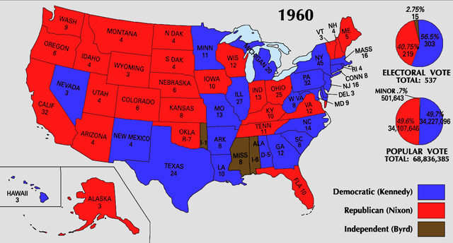
English: 1960 Electoral College Map |
| 来源 | https://nationalmap.gov/small_scale/printable/elections.html |
| 作者 | 美國地質調查局 |
许可协议
本地圖取自美國國家地圖集的某個版本。國家地圖集的絕大多數作品是美國聯邦政府的作品,因此屬於公有領域。
連結網址︰ NationalAtlas.gov | 1970年印刷版︰ 國會檔案館, Perry-Castañeda圖書館
|
文件历史
点击某个日期/时间查看对应时刻的文件。
| 日期/时间 | 缩略图 | 大小 | 用户 | 备注 | |
|---|---|---|---|---|---|
| 当前 | 2008年6月25日 (三) 22:16 | | 1,182 × 635(179 KB) | Tallicfan20 | |
| 2008年6月25日 (三) 21:44 |  | 1,182 × 635(179 KB) | Tallicfan20 | better coloring | |
| 2008年5月30日 (五) 06:36 |  | 1,182 × 635(164 KB) | Tallicfan20 | ||
| 2008年5月24日 (六) 17:31 |  | 1,182 × 635(165 KB) | Tallicfan20 | better coloring | |
| 2008年5月16日 (五) 17:38 |  | 1,182 × 635(109 KB) | Tallicfan20 | {{Information |Description=1960 Electoral College Map |Source=National Atlas |Date=5/16/2008 |Author=National Atlas |Permission=PD |other_versions= }} {{PD-USGov-Atlas}} |
文件用途
没有页面链接到本图像。
全域文件用途
以下其他wiki使用此文件:
- en.wikipedia.org上的用途
- hu.wikipedia.org上的用途
- sv.wikipedia.org上的用途
- uk.wikipedia.org上的用途