
File:2004 indian ocean earthquake details.png
此为最大尺寸。
2004_indian_ocean_earthquake_details.png (413 × 408像素,文件大小:26 KB,MIME类型:image/png)
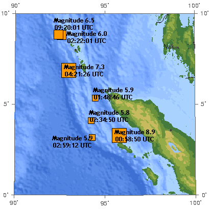
The 2004 Indian Ocean earthquake. There are 7 earthquakes on this map as of 17:00 UTC, December 26, 2004.
The original image was generated by the USGS and was found at https://earthquake.usgs.gov/recenteqsww/Maps/10/95_5.html -- Toytoy 17:40, Dec 26, 2004 (UTC).
The original image:
|
|
en:User:Toytoy's modification:
本文件采用知识共享署名-相同方式共享 1.0 通用许可协议授权。
- 您可以自由地:
- 共享 – 复制、发行并传播本作品
- 修改 – 改编作品
- 惟须遵守下列条件:
- 署名 – 您必须对作品进行署名,提供授权条款的链接,并说明是否对原始内容进行了更改。您可以用任何合理的方式来署名,但不得以任何方式表明许可人认可您或您的使用。
- 相同方式共享 – If you alter, transform, or build upon this work, you must distribute the resulting work under the same license as the original.
Note: many of the magnitudes and times of the earthquakes shown here have been revised since:
- 8.9 -> 9.0 (00:58:53) [1] archive copy at the Wayback Machine [2] archive copy at the Wayback Machine
- 7.3 -> 7.1 (04:21:29) [3] archive copy at the Wayback Machine
- 6.5 -> 6.6 (09:20:00) [4]
- 6.0 -> 5.8 [5] archive copy at the Wayback Machine
- 5.9 (02:59:12) -> 5.7 (02:59:14) [6] archive copy at the Wayback Machine
- 5.9 (01:48:46) -> 5.8 (01:48:49) [7] archive copy at the Wayback Machine
- 5.8 -> 5.7 (02:34:52) [8] archive copy at the Wayback Machine
Also, many more aftershocks have occurred. Therefore this image is out of date.
原始上传日志
| 日期/时间 | 大小 | 用户 | 备注 |
|---|---|---|---|
| 2004年12月31日, 02:45:36 | 413 × 408 (31787 bytes) | Amgine (留言 · 贡献) | The '''[[2004 Indian Ocean earthquake]]'''.There are 7 earthquakes on this map as of 17:00 UTC, December 26, 2004. |
文件历史
点击某个日期/时间查看对应时刻的文件。
| 日期/时间 | 缩略图 | 大小 | 用户 | 备注 | |
|---|---|---|---|---|---|
| 当前 | 2014年7月21日 (一) 09:31 | | 413 × 408(26 KB) | GifTagger | Bot: Converting file to superior PNG file. (Source: 2004_indian_ocean_earthquake_details.gif). This GIF was problematic due to non-greyscale color table. |
文件用途
以下2个页面使用本文件:
全域文件用途
以下其他wiki使用此文件:
- de.wikipedia.org上的用途
- en.wikipedia.org上的用途
- ga.wikipedia.org上的用途
- id.wikipedia.org上的用途
- ms.wikipedia.org上的用途
- nl.wikipedia.org上的用途
- no.wikipedia.org上的用途
- pl.wikipedia.org上的用途