
File:2010 Kaohsiung earthquake intensity USGS.jpg

本预览的尺寸:509 × 600像素。 其他分辨率:204 × 240像素 | 612 × 721像素。
原始文件 (612 × 721像素,文件大小:82 KB,MIME类型:image/jpeg)
| 描述 |
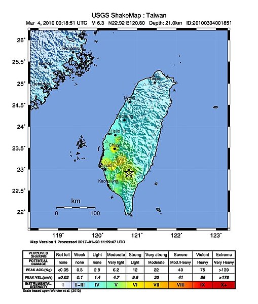
English: Shake map of the magnitude 6.4 earthquake of Taiwan on March 4, 2010. Epicenter marked at star. Sixth version of the map, realized by USGS on 3 MArch 2010 at 06:10:30 MST. |
|||
| 日期 | ||||
| 来源 | USGS | |||
| 作者 | USGS | |||
| 授权 (二次使用本文件) |
|
| 相机位置 | | 在以下服务上查看本图像和附近其他图像: OpenStreetMap |
|---|
文件历史
点击某个日期/时间查看对应时刻的文件。
| 日期/时间 | 缩略图 | 大小 | 用户 | 备注 | |
|---|---|---|---|---|---|
| 当前 | 2017年11月24日 (五) 05:05 | | 612 × 721(82 KB) | Alexchris | update |
| 2016年6月12日 (日) 14:05 |  | 612 × 715(74 KB) | Samchtt | update | |
| 2016年6月12日 (日) 14:03 |  | 612 × 715(74 KB) | Samchtt | update | |
| 2010年3月4日 (四) 05:03 |  | 612 × 715(75 KB) | A-lú-mih | {{Information |Description={{en|1=Shake map of the magnitude 6.4 earthquake of Taiwan on March 4, 2010. Epicenter marked at star. Sixth version of the map, realized by USGS on 3 MArch 2010 at 06:10:30 MST.}} |Source=[http:// |
文件用途
以下页面使用本文件:
全域文件用途
以下其他wiki使用此文件:
- en.wikipedia.org上的用途
- es.wikipedia.org上的用途
- fr.wikipedia.org上的用途
- id.wikipedia.org上的用途
- ja.wikipedia.org上的用途
- ms.wikipedia.org上的用途
- nl.wikipedia.org上的用途
- ru.wikipedia.org上的用途
- tl.wikipedia.org上的用途
- www.wikidata.org上的用途
- zh-min-nan.wikipedia.org上的用途