
File:Alaska climate regions USGS.gif
此为最大尺寸。
Alaska_climate_regions_USGS.gif (418 × 351像素,文件大小:17 KB,MIME类型:image/gif)
摘要
| 描述 |
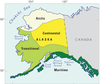
English: Schematic map showing a classification of modern-day climate zones in Alaska. This map is from a USGS website:Latest Wisconsin Deglaciation and Postglacial Vegetation Development in the Turnagain Arm Area, Upper Cook Inlet, South-Central Alaska |
| 日期 | 约2004年; last website update 2010 |
| 来源 | http://esp.cr.usgs.gov/research/alaska/turnarm.html |
| 作者 | Thomas A. Ager and Paul E. Carrara, USGS |
许可协议
此作品在美国属于公有领域,因为其是由美国政府的官员或雇员,基于其个人公务目的制作的作品,参考美国法典第17篇第1章第105条。
注意︰本模板仅适用于美国联邦政府的原创作品,不适用于任何美国州、属地、联邦个体、县、市或任何次级政府的作品。本模板也不适用于1978年以后由美国邮政署出版的邮票图案(参看美国版权局实践纲领第313.6(C)(1)条)。也不适用于部分美国硬币;参看美国铸币局使用条款。 |
 | |
| 本文件已被确认为免除已知的著作权法限制(包括所有相关权利)。 | ||
文件历史
点击某个日期/时间查看对应时刻的文件。
| 日期/时间 | 缩略图 | 大小 | 用户 | 备注 | |
|---|---|---|---|---|---|
| 当前 | 2012年7月28日 (六) 18:34 | | 418 × 351(17 KB) | Dankarl | edited out "fig 3" locator box to make figure useful for other applications |
| 2012年7月27日 (五) 15:05 |  | 418 × 351(17 KB) | Dankarl |
文件用途
以下页面使用本文件:
全域文件用途
以下其他wiki使用此文件: