
File:Ardf map.png
Ardf_map.png (600 × 550像素,文件大小:430 KB,MIME类型:image/png)
source/author
摘要
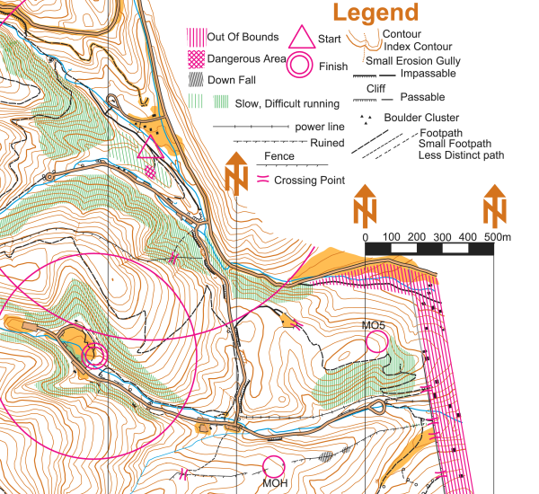
On this portion of an ARDF map, the start location is indicated by a triangle and the finish location is indicated by two concentric circles. The locations of two of the five transmitters are indicated on this version of the map with circles and the labels MOH and MO5 - on the versions of the map given to competitors, the locations of the transmitters are not indicated.
This map is a portion of the Cibola National Forest in the Sandia Mountains east of Albuquerque, New Mexico, USA. The map was used for the eighty meter competition of the Third IARU Region II ARDF Championship, August 5, 2005. This map is not created to International Orienteering Federation standards for orienteering maps.
The map was created in 2005 by Jerry Boyd of Albuquerque, New Mexico, with field checking by Gail Boyd, Taylor Boyd, Jack Stump, Scott Stevenson, and Jerry Boyd. Contact information for these individuals is available at the Albuquerque Transmitter Hunters archive copy at the Wayback Machine web site. This image of the map has been released under GFDL by its author, Jerry Boyd, and is used with permission.
A subsequent map of the same terrain has been created from scratch by professional mapmakers working on behalf of New Mexico Orienteers archive copy at the Wayback Machine. Work on that map began in 2005, after the completion of the 2005 IARU Region II ARDF Championship.
许可协议
| 本文件采用知识共享署名-相同方式共享 3.0 未本地化版本许可协议授权。 受免責聲明的約束。 | ||
| ||
| 本许可协议标签作为GFDL许可协议更新的组成部分被添加至本文件。 |

|
已授权您依据自由软件基金会发行的无固定段落及封面封底文字(Invariant Sections, Front-Cover Texts, and Back-Cover Texts)的GNU自由文件许可协议1.2版或任意后续版本的条款,复制、传播和/或修改本文件。该协议的副本请见“GNU Free Documentation License”。 受免責聲明的約束。 |
文件历史
点击某个日期/时间查看对应时刻的文件。
| 日期/时间 | 缩略图 | 大小 | 用户 | 备注 | |
|---|---|---|---|---|---|
| 当前 | 2006年3月12日 (日) 20:46 | | 600 × 550(430 KB) | Greudin | == Summary == On this portion of an ARDF map, the start location is indicated by a triangle and the finish location is indicated by two concentric circles. The locations of two of the five transmitters are indicated on |
文件用途
全域文件用途
以下其他wiki使用此文件:
- cs.wikipedia.org上的用途
- en.wikipedia.org上的用途
- en.wikibooks.org上的用途
- en.wikiversity.org上的用途
- en.wikivoyage.org上的用途
- fr.wikipedia.org上的用途
- pl.wikipedia.org上的用途
- sk.wikipedia.org上的用途
- zh-yue.wikipedia.org上的用途