
File:Greater austria.png

本预览的尺寸:703 × 600像素。 其他分辨率:281 × 240像素 | 563 × 480像素 | 900 × 768像素 | 1,200 × 1,024像素 | 1,500 × 1,280像素。
原始文件 (1,500 × 1,280像素,文件大小:45 KB,MIME类型:image/png)
摘要
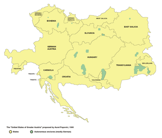
- English: map of the proposed United States of Greater Austria in 1906
- Serbian: мапа предложених Сједињених Држава Велике Аустрије (1906. године)
Source and licence

|
This map has been uploaded by Electionworld from en.wikipedia.org to enable the |
| 本作品已被作者PANONIAN释出到公有领域。这适用于全世界。 在一些国家这可能不合法;如果是这样的话,那么: |
self made map by user:PANONIAN
see de:Bild:Vereinigte Staaten von Groß-Österreich.png for german version. --Rdb 12:12, 2 April 2007 (UTC)
文件历史
点击某个日期/时间查看对应时刻的文件。
| 日期/时间 | 缩略图 | 大小 | 用户 | 备注 | |
|---|---|---|---|---|---|
| 当前 | 2006年12月23日 (六) 22:47 | | 1,500 × 1,280(45 KB) | Electionworld | {{ew|en|PANONIAN}} {{PD-user|PANONIAN}} map of the {{link|United States of Greater Austria}} (self made) |
文件用途
以下页面使用本文件:
全域文件用途
以下其他wiki使用此文件:
- be.wikipedia.org上的用途
- cy.wikipedia.org上的用途
- el.wikipedia.org上的用途
- en.wikipedia.org上的用途
- eu.wikipedia.org上的用途
- fi.wikipedia.org上的用途
- fr.wikipedia.org上的用途
- hu.wikipedia.org上的用途
- id.wikipedia.org上的用途
- it.wikipedia.org上的用途
- ja.wikipedia.org上的用途
- ko.wikipedia.org上的用途
- lmo.wikipedia.org上的用途
- pt.wikipedia.org上的用途
- ro.wikipedia.org上的用途
- ru.wikipedia.org上的用途
- sk.wikipedia.org上的用途
- uk.wikipedia.org上的用途
- vi.wikipedia.org上的用途