
File:Gula Mons 3D.jpg

本预览的尺寸:750 × 600像素。 其他分辨率:300 × 240像素 | 600 × 480像素 | 960 × 768像素 | 1,250 × 1,000像素。
原始文件 (1,250 × 1,000像素,文件大小:114 KB,MIME类型:image/jpeg)
摘要
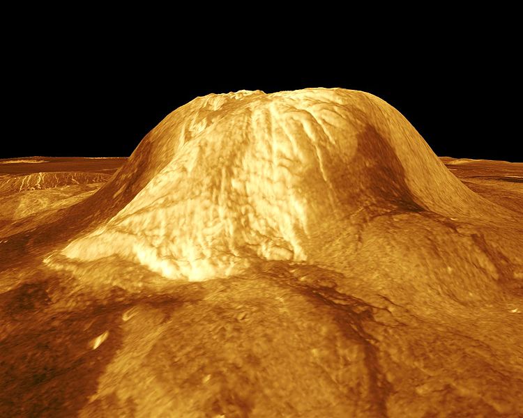
| 描述 | Gula Mons is displayed in this computer-simulated view of the surface of Venus. The viewpoint is located 110 kilometers (68 miles) southwest of Gula Mons at the same elevation as the summit, 3 kilometers (1.9 miles) above Eistla Regio. Lava flows extend for hundreds of kilometers across the fractured plains. The view is to the northeast with Gula Mons appearing at the center of the image. Gula Mons, a 3 kilometer (1.9 mile) high volcano, is located at approximately 22 degrees north latitude, 359 degrees east longitude in western Eistla Regio. Magellan synthetic aperture radar data is combined with radar altimetry to produce a three-dimensional map of the surface. Rays cast in a computer intersect the surface to create a three-dimensional perspective view. Simulated color and a digital elevation map developed by the U.S. Geological Survey are used to enhance small-scale structure. The simulated hues are based on color images recorded by the Soviet Venera 13 and 14 spacecraft. The image was produced by the JPL Multimission Image Processing Laboratory and is a single frame from a video released at the March 5, 1991, JPL news conference. |
| 来源 | http://photojournal.jpl.nasa.gov/catalog/PIA00234 |
| 作者 | JPL/NASA |
| 此标签不表示文件的著作权状态。任何文件在附有此标签的同時还需要一个有效的著作权标签。请参阅许可协议说明页面以了解更多信息。 其他语言:
|
许可协议
| 本文件完全由NASA创作,在美国属于公有领域。根据NASA的版权方针,NASA的材料除非另有声明否则不受版权保护。(参见Template:PD-USGov/zh、NASA版权方针页面或JPL图片使用方针。) | ||
 |
警告:
|
文件历史
点击某个日期/时间查看对应时刻的文件。
| 日期/时间 | 缩略图 | 大小 | 用户 | 备注 | |
|---|---|---|---|---|---|
| 当前 | 2007年11月25日 (日) 21:27 | | 1,250 × 1,000(114 KB) | Lotse | {{Information |Description=Gula Mons is displayed in this computer-simulated view of the surface of Venus. The viewpoint is located 110 kilometers (68 miles) southwest of Gula Mons at the same elevation as the summit, 3 kilometers (1.9 miles) above Eistla |
文件用途
以下页面使用本文件:
全域文件用途
以下其他wiki使用此文件:
- ar.wikipedia.org上的用途
- de.wikipedia.org上的用途
- en.wikipedia.org上的用途
- es.wikipedia.org上的用途
- fr.wikipedia.org上的用途
- it.wikipedia.org上的用途
- nl.wikipedia.org上的用途
- pt.wikipedia.org上的用途
- sk.wikipedia.org上的用途
- uk.wikipedia.org上的用途
- www.wikidata.org上的用途