
File:Hellas MOLA zoom 64 small.jpg

本预览的尺寸:672 × 600像素。 其他分辨率:269 × 240像素 | 538 × 480像素 | 860 × 768像素 | 1,147 × 1,024像素 | 2,294 × 2,048像素 | 5,600 × 5,000像素。
原始文件 (5,600 × 5,000像素,文件大小:10.03 MB,MIME类型:image/jpeg)
摘要
| 描述 |
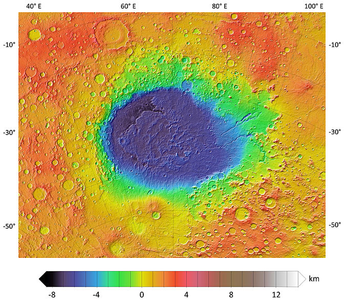
English: A colorized topographic map of the martian impact basin Hellas, together with its surroundings, from the Mars Orbiter Laser Altimeter (MOLA) instrument of the Mars Global Surveyor spacecraft. Hellas, the deepest basin on Mars, lies in the southern hemisphere, south of Syrtis Major Planum. |
| 日期 | |
| 来源 | JMARS |
| 作者 | NASA / JPL-Caltech / Arizona State University |
| 其他版本 |
|


许可协议
| 本文件完全由NASA创作,在美国属于公有领域。根据NASA的版权方针,NASA的材料除非另有声明否则不受版权保护。(参见Template:PD-USGov/zh、NASA版权方针页面或JPL图片使用方针。) | ||
 |
警告:
|
文件历史
点击某个日期/时间查看对应时刻的文件。
| 日期/时间 | 缩略图 | 大小 | 用户 | 备注 | |
|---|---|---|---|---|---|
| 当前 | 2013年12月1日 (日) 23:16 | | 5,600 × 5,000(10.03 MB) | WolfmanSF | User created page with UploadWizard |
文件用途
以下页面使用本文件:
全域文件用途
以下其他wiki使用此文件:
- ca.wikipedia.org上的用途
- eo.wikipedia.org上的用途
- es.wikipedia.org上的用途
- fi.wikipedia.org上的用途
- it.wikipedia.org上的用途
- nl.wikipedia.org上的用途
- pl.wikipedia.org上的用途
- pt.wikipedia.org上的用途
- sk.wikipedia.org上的用途