
File:India Uttar Pradesh location map.svg

此SVG文件的PNG预览的大小:615 × 600像素。 其他分辨率:246 × 240像素 | 492 × 480像素 | 788 × 768像素 | 1,050 × 1,024像素 | 2,100 × 2,048像素 | 1,006 × 981像素。
原始文件 (SVG文件,尺寸为1,006 × 981像素,文件大小:776 KB)
摘要
| 描述 |
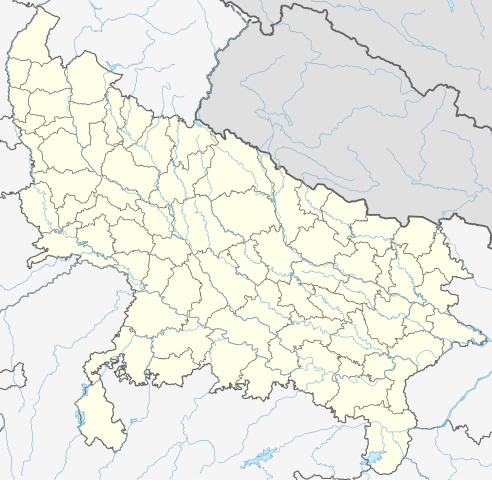
Quadratische Plattkarte, N-S-Streckung 112 %. Geographische Begrenzung der Karte:
Equirectangular projection, N/S stretching 112 %. Geographic limits of the map:
|
|
| 日期 | ||
| 来源 |
自己的作品, using
|
|
| 作者 | NordNordWest | |
| 授权 (二次使用本文件) |
本文件采用知识共享署名-相同方式共享 3.0 德国许可协议授权。
 本文件采用知识共享署名-相同方式共享 3.0 德国许可协议授权。
|


|
|
文件历史
点击某个日期/时间查看对应时刻的文件。
| 日期/时间 | 缩略图 | 大小 | 用户 | 备注 | |
|---|---|---|---|---|---|
| 当前 | 2023年5月1日 (一) 06:40 | | 1,006 × 981(776 KB) | C1MM | c borders |
| 2022年1月5日 (三) 04:44 |  | 1,066 × 927(777 KB) | C1MM | Corrected rivers and dist boundaries | |
| 2021年2月12日 (五) 22:54 |  | 909 × 886(262 KB) | C1MM | Added Chhattisgarh | |
| 2021年1月8日 (五) 00:41 |  | 909 × 886(261 KB) | C1MM | Added Amethi district | |
| 2020年4月22日 (三) 21:29 |  | 909 × 886(249 KB) | NordNordWest | Reverted to version as of 19:51, 9 October 2012 (UTC); no need to change colours | |
| 2020年4月22日 (三) 21:00 |  | 909 × 886(292 KB) | C1MM | Fixed rivers | |
| 2020年4月22日 (三) 20:51 |  | 909 × 886(290 KB) | C1MM | Fixed colors and made rivers along borders | |
| 2012年10月9日 (二) 19:51 |  | 909 × 886(249 KB) | NordNordWest | =={{int:filedesc}}== {{Information |Description= {{de|Positionskarte von Uttar Pradesh, Indien}} Quadratische Plattkarte, N-S-Streckung 112 %. Geographische Begrenzung der Karte: * N: 30.5° N * S: 23.8° N * W: 77.... |
文件用途
以下14个页面使用本文件:
全域文件用途
以下其他wiki使用此文件:
- ar.wikipedia.org上的用途
- as.wikipedia.org上的用途
- awa.wikipedia.org上的用途
- azb.wikipedia.org上的用途
- اتاوه
- کینتور
- علیپورا
- فولپور
- فولی (هیندوستان)
- ففنا (هیندوستان)
- فارندا
- سارسای ناوار
- ساروخیپورا
- ساراوان, جاونپور
- ساراسارا, یوتار پرادش
- ساراییا بور
- سارایبیرو
- مداوارا کالا
- سانخنی
- ماوجامپور
- ماسکانوا
- سانای, بوداون
- سامرر (هیندوستان)
- کالاند, ایندیا
- مارتین پوروا
- سامبالهرا
- کاکورا
- سالارپور, بوداون
- کایتورا, جاونپور
- ساییان, آقرا
- ساینتال, یوتار پرادش
- سایفای
- کاقارول
- سایدناقار
- ساهاجانپور
- هالاور
- سافدارقانج
- سادپور, یوتار پرادش
- روپایدیها
- رابارلی
- کادار چووک
查看本文件的更多全域用途。