
File:Jangmi 2008-09-27 0445Z.jpg

本预览的尺寸:473 × 599像素。 其他分辨率:189 × 240像素 | 379 × 480像素 | 606 × 768像素 | 808 × 1,024像素 | 1,617 × 2,048像素 | 6,000 × 7,600像素。
原始文件 (6,000 × 7,600像素,文件大小:4.93 MB,MIME类型:image/jpeg)
摘要
| 描述 |
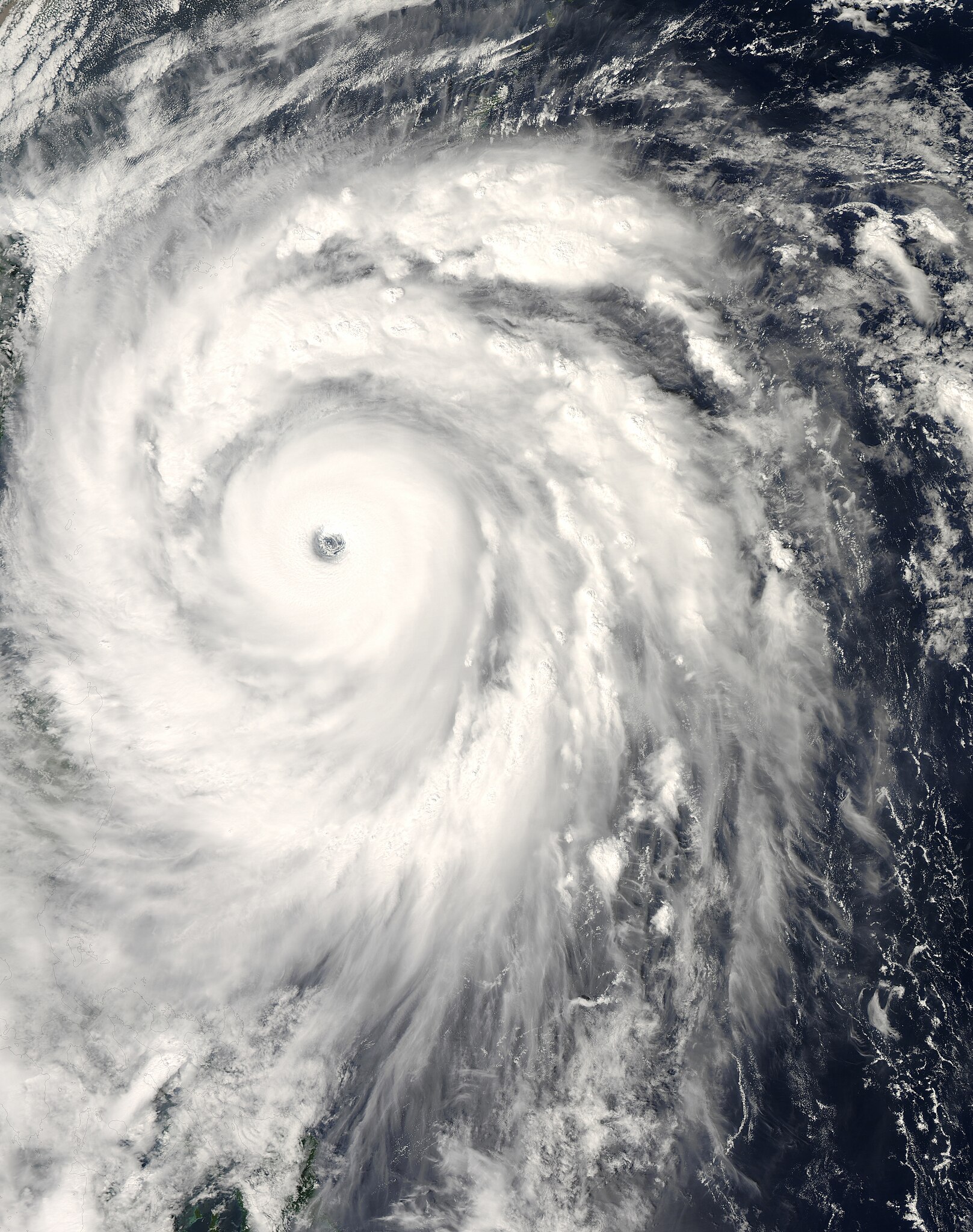
English: The title of “strongest storm of 2008” goes to Typhoon Jangmi, shown in this image from the Moderate Resolution Imaging Spectroradiometer (MODIS) on NASA’s Aqua satellite from September 27, 2008.
Seen from space, even a super typhoon seems more beautiful than dangerous. The 50-kilometer-wide eye of Jangmi is encircled by a smooth disk of clouds. Bands of clouds swirl gracefully into the low-pressure heart of the storm. The smooth cloud band north of the eye is studded with thunderstorms. On the ground, Jangmi was less lovely It was not only the strongest storm in any ocean basin in 2008 but the only storm to reach category 5 strength anywhere in the world that year. |
| 日期 | |
| 来源 | http://rapidfire.sci.gsfc.nasa.gov/cgi-bin/imagery/single.cgi?image=Jangmi.A2008271.0445.250m.jpg |
| 作者 | MODIS image captured by NASA’s Aqua satellite |
| 相机位置 | | 在以下服务上查看本图像和附近其他图像: OpenStreetMap |
|---|
许可协议
| 本文件完全由NASA创作,在美国属于公有领域。根据NASA的版权方针,NASA的材料除非另有声明否则不受版权保护。(参见Template:PD-USGov/zh、NASA版权方针页面或JPL图片使用方针。) | ||
 |
警告:
|
文件历史
点击某个日期/时间查看对应时刻的文件。
| 日期/时间 | 缩略图 | 大小 | 用户 | 备注 | |
|---|---|---|---|---|---|
| 当前 | 2018年5月30日 (三) 13:58 | | 6,000 × 7,600(4.93 MB) | Nino Marakot | Reverted to version as of 05:09, 9 January 2018 (UTC) |
| 2018年4月21日 (六) 23:03 |  | 1,723 × 2,089(1.06 MB) | Saxitoxin | Less gray | |
| 2018年4月21日 (六) 23:02 |  | 1,723 × 2,089(2.64 MB) | Saxitoxin | More storm centered | |
| 2018年1月9日 (二) 05:09 |  | 6,000 × 7,600(4.93 MB) | Nino Marakot | Reverted to version as of 22:20, 2 November 2008 (UTC) - It's gallery version. Please separate them (it would become 3rd party if stayed) | |
| 2017年11月24日 (五) 15:48 |  | 5,985 × 7,980(9.62 MB) | Meow | Rebuilt. | |
| 2008年11月2日 (日) 22:20 |  | 6,000 × 7,600(4.93 MB) | Cyclonebiskit | {{Information |Description={{en|1={{en|1=Satellite image of Typhoon Jangmi at 0445 UTC Sept. 27, 2008.}}This photo-like image was taken by the Aqua MODIS Satellite as Typhoon Jangmi (or Super Typhoon 19W according to the JTWC) moved closer to the island o |
文件用途
全域文件用途
以下其他wiki使用此文件:
- de.wikipedia.org上的用途
- en.wikipedia.org上的用途
- ja.wikipedia.org上的用途
- ko.wikipedia.org上的用途
- pt.wikipedia.org上的用途
- vi.wikipedia.org上的用途
- zh-yue.wikipedia.org上的用途