
File:Maja Valles Streamlined Island.jpg

本预览的尺寸:550 × 599像素。 其他分辨率:220 × 240像素 | 614 × 669像素。
原始文件 (614 × 669像素,文件大小:53 KB,MIME类型:image/jpeg)
摘要
| 描述 |
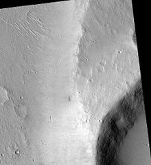
English: Maja Valles Streamlined Island, as seen by hirise. Location is 15.8 degrees north latitude and 301.9 degrees east longitude. Image was taken by the Mars Reconnaissance Orbiter's HiRISE. The HiRISE camera was built by Ball Aerospace and Technology orporation and is operated by the University of Arizona. Image courtesy NASA/JPL/University of Arizona. |
| 日期 | |
| 来源 | http://hirise.lpl.arizona.edu/PSP_002181_1960 |
| 作者 | Jim Secosky modified NASA image. |
许可协议
| 本文件完全由NASA创作,在美国属于公有领域。根据NASA的版权方针,NASA的材料除非另有声明否则不受版权保护。(参见Template:PD-USGov/zh、NASA版权方针页面或JPL图片使用方针。) | ||
 |
警告:
|
原始上传日志
原始描述頁面位於這裡。下列使用者名稱均來自en.wikipedia。
| 日期/时间 | 大小 | 用户 | 备注 |
|---|---|---|---|
| 2009-03-11 22:26 | 614×669× (53856 bytes) | Jimmarsmars | {{Information |Description=Maja Valles Streamlined Island, as seen by hirise. Location is 15.8 degrees north latitude and 301.9 degrees east longitude. |Source=http://hirise.lpl.arizona.edu/PSP_002181_1960 |Date=March 11, 2009 |Author=Jim Secosky modifie |
文件历史
点击某个日期/时间查看对应时刻的文件。
| 日期/时间 | 缩略图 | 大小 | 用户 | 备注 | |
|---|---|---|---|---|---|
| 当前 | 2014年11月27日 (四) 01:03 | | 614 × 669(53 KB) | Piramidion | Transferred from en.wikipedia |
文件用途
以下页面使用本文件:
全域文件用途
以下其他wiki使用此文件:
- cs.wikipedia.org上的用途
- en.wikipedia.org上的用途
- uk.wikipedia.org上的用途