
File:Majapahit Empire.svg

此SVG文件的PNG预览的大小:512 × 297像素。 其他分辨率:320 × 186像素 | 640 × 371像素 | 1,024 × 594像素 | 1,280 × 743像素 | 2,560 × 1,485像素。
原始文件 (SVG文件,尺寸为512 × 297像素,文件大小:524 KB)
摘要
| 描述 |
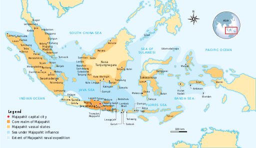
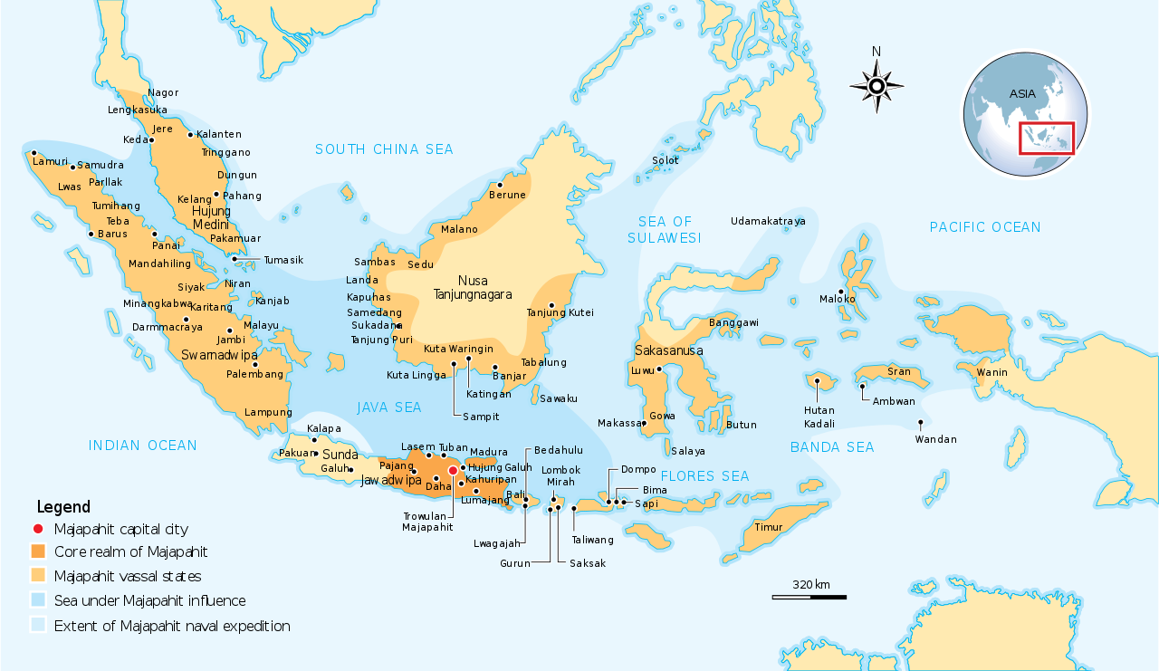
English: The Nusantara Archipelago during the height of Majapahit Empire in XIV century.
The red dot is Trowulan; Majapahit capital city. The dark orange area is core realm of Majapahit on eastern part of Java. The light orange area is vassal states of Majapahit mentioned in Nagarakretagama. The pale yellow is outer realm or independent states from Majapahit. The dark cyan is the sea area under influence or effective control of Majapahit. The light cyan is the extent of Majapahit naval expedition. |
||
| 日期 | |||
| 来源 | Own work by uploader, see #References for references used creating the map. | ||
| 作者 | Gunawan Kartapranata | ||
| 授权 (二次使用本文件) |
我,本作品著作权人,特此采用以下许可协议发表本作品: 本文件采用知识共享署名-相同方式共享 3.0 未本地化版本许可协议授权。
您可以选择您需要的许可协议。 |
||
| 其他版本 |
[] []
|


|
此SVG檔案包含可翻譯至您的語言的内嵌文字,可以使用任何可用SVG編輯器、文本編輯器或SVG翻譯工具來翻譯。詳情請見:關於翻譯SVG檔案。 |
References
Resources used to create the map:
- (2007年6月21日) 《 Majapahit》、Kompas Daily, Jakarta Indonesia
- Latif, Chalid; Irwin Lay , ed. (1997年) 《 Atlas Sejarah Indonesia dan Dunia (Historical Atlas of Indonesia and World)》、PT Pembina Peraga, Jakarta
- (indonesian) 《 IPS Terpadu (Sosiologi, Geografi, Ekonomi, Sejarah)》、PT Grafindo Media Pratama、第219頁 ISBN: 9789797583378.
文件历史
点击某个日期/时间查看对应时刻的文件。
| 日期/时间 | 缩略图 | 大小 | 用户 | 备注 | |
|---|---|---|---|---|---|
| 当前 | 2016年10月28日 (五) 13:07 | | 512 × 297(524 KB) | Gunkarta | Correction on Luwu location |
| 2009年11月5日 (四) 10:13 |  | 781 × 457(525 KB) | Gunkarta | Corrected the location of Malano in northeast coast of Borneo and Wanin/Onin in Papua (today Fak-fak). | |
| 2009年8月10日 (一) 15:43 |  | 781 × 457(525 KB) | Gunkarta | Crop the map again | |
| 2009年8月10日 (一) 15:37 |  | 781 × 463(529 KB) | Gunkarta | Crop the map | |
| 2009年8月10日 (一) 15:27 |  | 986 × 610(582 KB) | Gunkarta | {{Information |Description={{en|1=The Nusantara Archipelago during the height of Majapahit Empire in XIV century. 1. The red dot is Trowulan; Majapahit capital city 2. The dark orange area is core realm of Majapahit on eastern part of Java 3. The light o |
文件用途
以下页面使用本文件:
全域文件用途
以下其他wiki使用此文件:
- ar.wikipedia.org上的用途
- arz.wikipedia.org上的用途
- ast.wikipedia.org上的用途
- ba.wikipedia.org上的用途
- bcl.wikipedia.org上的用途
- bg.wikipedia.org上的用途
- bn.wikipedia.org上的用途
- ca.wikipedia.org上的用途
- cs.wikipedia.org上的用途
- de.wikipedia.org上的用途
- en.wikipedia.org上的用途
- eo.wikipedia.org上的用途
- eu.wikipedia.org上的用途
- fa.wikipedia.org上的用途
- fi.wikipedia.org上的用途
- fr.wikipedia.org上的用途
- gl.wikipedia.org上的用途
- he.wikipedia.org上的用途
- hi.wikipedia.org上的用途
- id.wikipedia.org上的用途
- id.wikisource.org上的用途
- id.wiktionary.org上的用途
- it.wikipedia.org上的用途
- ja.wikipedia.org上的用途
- km.wikipedia.org上的用途
- ko.wikipedia.org上的用途
- lt.wikipedia.org上的用途
- min.wikipedia.org上的用途
- ml.wikipedia.org上的用途
- mr.wikipedia.org上的用途
- ms.wikipedia.org上的用途
- mt.wikipedia.org上的用途
- ne.wikipedia.org上的用途
查看本文件的更多全域用途。