
File:Map of Taungoo Empire (1580).png

本预览的尺寸:508 × 599像素。 其他分辨率:203 × 240像素 | 407 × 480像素 | 950 × 1,121像素。
原始文件 (950 × 1,121像素,文件大小:1.5 MB,MIME类型:image/png)
.png?uselang=zh)
.png?uselang=zh)
.png?action=history&uselang=zh)
.png)
摘要
| 描述 |
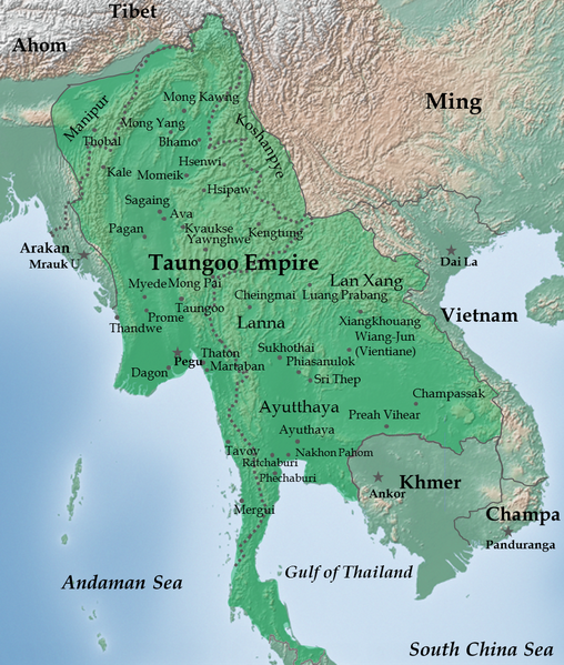
English: Taungoo Empire at its highest extent during the reign of King Bayinnaung (1551-1581) |
| 日期 | |
| 来源 | 自己的作品. Background map is taken from www.naturalearthdata.com (public domain: Terms of Use). |
| 作者 | Soewinhan |
References

Refer to the
- timemap from University of California, Berkeley archive copy at the Wayback Machine for the extent of Ayutthaya, Lang Xang and Lanna before Bayinnaung's conquest.
- Victor B. Lieberman (2003年) 《 Strange parallels: Southeast Asia in global context, c 800-1830, Volume 1》、pp. 152 ISBN: 0521804965. for the extent of Taungoo Empire as of 1580.
- File:Map of Toungoo Kingdom 1572.jpg and File:Map-of-southeast-asia 900 CE.png for geographic names.
- Baker, Chris. Phongpaichit, Pasuk. A History of Ayutthaya: Siam in the Early Modern World.
Notes
- The borders at that times were not demarcated. As stated in Berkeley timemap: The level of details present in some boundaries should not be interpreted as a result of a precise, detailed understanding of the borders of states during this period.
许可协议
我,本作品著作权人,特此采用以下许可协议发表本作品:
本文件采用知识共享署名-相同方式共享 3.0 未本地化版本许可协议授权。
- 您可以自由地:
- 共享 – 复制、发行并传播本作品
- 修改 – 改编作品
- 惟须遵守下列条件:
- 署名 – 您必须对作品进行署名,提供授权条款的链接,并说明是否对原始内容进行了更改。您可以用任何合理的方式来署名,但不得以任何方式表明许可人认可您或您的使用。
- 相同方式共享 – 如果您再混合、转换或者基于本作品进行创作,您必须以与原先许可协议相同或相兼容的许可协议分发您贡献的作品。
文件历史
点击某个日期/时间查看对应时刻的文件。
| 日期/时间 | 缩略图 | 大小 | 用户 | 备注 | |
|---|---|---|---|---|---|
| 当前 | 2023年7月14日 (五) 02:28 | | 950 × 1,121(1.5 MB) | Yourlocallordandsavior | Reverted to version as of 06:37, 14 February 2023 (UTC) |
| 2023年2月14日 (二) 06:42 |  | 950 × 1,121(1.66 MB) | Yourlocallordandsavior | Reverted to version as of 02:30, 12 February 2023 (UTC) | |
| 2023年2月14日 (二) 06:37 |  | 950 × 1,121(1.5 MB) | Yourlocallordandsavior | Reverted to version as of 07:39, 21 February 2013 (UTC) | |
| 2023年2月12日 (日) 02:30 |  | 950 × 1,121(1.66 MB) | Yourlocallordandsavior | Ayutthaya did not exert its influence down the peninsula in the 16th century. | |
| 2013年2月21日 (四) 07:39 |  | 950 × 1,121(1.5 MB) | Super Rad! | Cropped 1-px transparent border on left and blue border on bottom; reduced image size using PNGOUT | |
| 2011年12月22日 (四) 06:25 |  | 951 × 1,124(2.31 MB) | Soewinhan | ||
| 2011年12月20日 (二) 13:33 |  | 951 × 1,118(2.29 MB) | Soewinhan |
文件用途
全域文件用途
以下其他wiki使用此文件:
- ar.wikipedia.org上的用途
- azb.wikipedia.org上的用途
- ba.wikipedia.org上的用途
- bn.wikipedia.org上的用途
- ca.wikipedia.org上的用途
- cs.wikipedia.org上的用途
- en.wikipedia.org上的用途
- es.wikipedia.org上的用途
- eu.wikipedia.org上的用途
- id.wikipedia.org上的用途
- it.wikipedia.org上的用途
- ja.wikipedia.org上的用途
- km.wikipedia.org上的用途
- ko.wikipedia.org上的用途
- lt.wikipedia.org上的用途
- mni.wikipedia.org上的用途
- my.wikipedia.org上的用途
- no.wikipedia.org上的用途
- pa.wikipedia.org上的用途
- pl.wikipedia.org上的用途
- pt.wikipedia.org上的用途
查看本文件的更多全域用途。
.png)
.png)