
File:Basin of Mexico 1519 map-en.svg

此SVG文件的PNG预览的大小:449 × 599像素。 其他分辨率:180 × 240像素 | 360 × 480像素 | 576 × 768像素 | 768 × 1,024像素 | 1,536 × 2,048像素 | 1,412 × 1,883像素。
原始文件 (SVG文件,尺寸为1,412 × 1,883像素,文件大小:526 KB)
摘要
| 描述 |
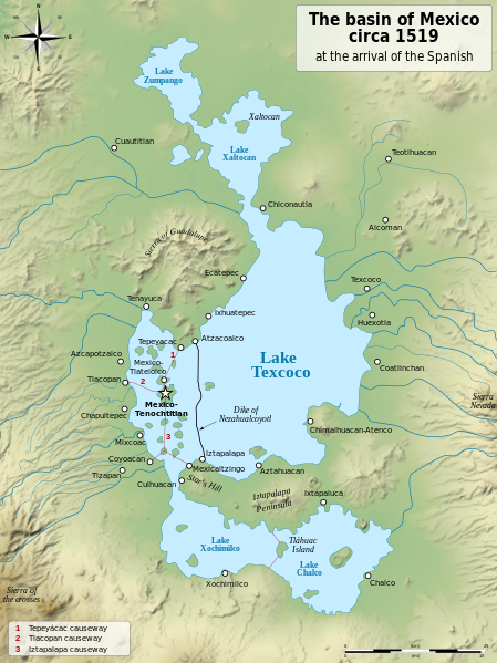
English: Map of the basin of Mexico circa 1519, at the arrival of the Spanish.
Español: Mapa de la cuenca de México acerca 1519, a la llegada de los españoles
Français : Carte du bassin de Mexico vers 1519, à l'arrivée des Espagnols. |
| 日期 | (UTC) |
| 来源 |
|
| 作者 |
|
| 其他版本 |
[]
|
| SVG开发 | 此SVG 文件使用了内嵌文本,可以使用任何文本编辑器轻松翻译。 |


| 相机位置 | | 在以下服务上查看本图像和附近其他图像: OpenStreetMap |
|---|
许可协议
我,本作品著作权人,特此采用以下许可协议发表本作品:
| 非营利著作权:本艺术作品是自由的,您可以依据自由艺术作品许可协议的条款传播和/或修改本艺术作品。您可以在Copyleft Attitude网站或其他网站找到该许可协议的样本。 |
This file is licensed under the Creative Commons Attribution-Share Alike 4.0 International, 3.0 Unported, 2.5 Generic, 2.0 Generic and 1.0 Generic license.
- 您可以自由地:
- 共享 – 复制、发行并传播本作品
- 修改 – 改编作品
- 惟须遵守下列条件:
- 署名 – 您必须对作品进行署名,提供授权条款的链接,并说明是否对原始内容进行了更改。您可以用任何合理的方式来署名,但不得以任何方式表明许可人认可您或您的使用。
- 相同方式共享 – 如果您再混合、转换或者基于本作品进行创作,您必须以与原先许可协议相同或相兼容的许可协议分发您贡献的作品。
您可以选择您需要的许可协议。
原始上传日志
This image is a derivative work of the following images:
- File:Lago_de_Texcoco-posclásico.png licensed with PD-self, PD-self/fr
- 2006-09-19T01:46:06Z Yavidaxiu 1412x1644 (344123 Bytes) {{Information |Description={{es|Mapa de la cuenca de México a la llegada de los españoles}} |Source=Trabajo propio |Date=18 de septiembre de 2006 |Author=Yavidaxiu |Permission={{PD-self}} |other_versions= }} [[Category:Map
- File:Valley_of_Mexico_c.1519-fr.svg licensed with Cc-by-sa-2.5,2.0,1.0, Cc-by-sa-3.0-migrated, GFDL
- 2007-09-11T14:00:14Z Historicair 731x849 (270643 Bytes)
- 2007-09-11T13:51:30Z Historicair 731x849 (272818 Bytes) {{Information |Description={{fr|Les environs de Tenochtitlan vers 1519}} {{en|Valley of Mexico circa 1519}} |Source=Own work |Date=11/09/2007 |Author=~~~~ |Permission={{self2|GFDL|cc-by-sa-2.5,2.0,1.0}} |other_versions= }} {{
Uploaded with derivativeFX
文件历史
点击某个日期/时间查看对应时刻的文件。
| 日期/时间 | 缩略图 | 大小 | 用户 | 备注 | |
|---|---|---|---|---|---|
| 当前 | 2021年1月28日 (四) 20:29 | | 1,412 × 1,883(526 KB) | Sémhur | Huexotla <=> Coatlinchán |
| 2013年7月17日 (三) 05:40 |  | 1,412 × 1,883(525 KB) | Citypeek | Enlargement of the legenda in the upper right corner. | |
| 2013年7月17日 (三) 05:33 |  | 1,412 × 1,883(533 KB) | Citypeek | Corrected two errors. Valid SVG now. | |
| 2010年2月8日 (一) 18:37 |  | 1,412 × 1,883(533 KB) | Sémhur | + relief and some improvements | |
| 2010年1月31日 (日) 09:45 |  | 1,412 × 1,645(99 KB) | Sémhur | == {{int:filedesc}} == {{Information |Description= {{en|Map of the basin of Mexico circa 1519, at the arrival of the Spanish.}} {{es|Mapa de la cuenca de México acerca 1519, a la llegada de los españoles}} {{fr|Carte du bassin de Mexico vers 1519, à l |
文件用途
没有页面链接到本图像。
全域文件用途
以下其他wiki使用此文件:
- azb.wikipedia.org上的用途
- ba.wikipedia.org上的用途
- br.wikipedia.org上的用途
- de.wikipedia.org上的用途
- en.wikipedia.org上的用途
- Aztecs
- Iztapalapa
- Lake Texcoco
- Valley of Mexico
- Aztec Empire
- Altiplano Cundiboyacense
- Tenayuca
- User:Kazkaskazkasako/Books/History
- User:Maunus/sandbox
- List of conflicts in Mexico
- Lake Zumpango
- Lake Tauca
- User:SomeGuyWhoRandomlyEdits/List of conflicts in Mexico
- Sierra de Guadalupe, Mexico
- Battle of Colhuacatonco
- en.wikibooks.org上的用途
- es.wikipedia.org上的用途
- fi.wikibooks.org上的用途
- hr.wikipedia.org上的用途
- hy.wikipedia.org上的用途
- id.wikipedia.org上的用途
- ja.wikipedia.org上的用途
- ka.wikipedia.org上的用途
- la.wikipedia.org上的用途
- nl.wikipedia.org上的用途
- nv.wikipedia.org上的用途
- pl.wikipedia.org上的用途
- rue.wikipedia.org上的用途
- ru.wikipedia.org上的用途
- sv.wikipedia.org上的用途
- ta.wikipedia.org上的用途
- tr.wikipedia.org上的用途
- vi.wikipedia.org上的用途