
File:Milpitas view2.JPG

原始文件 (2,104 × 1,580像素,文件大小:872 KB,MIME类型:image/jpeg)
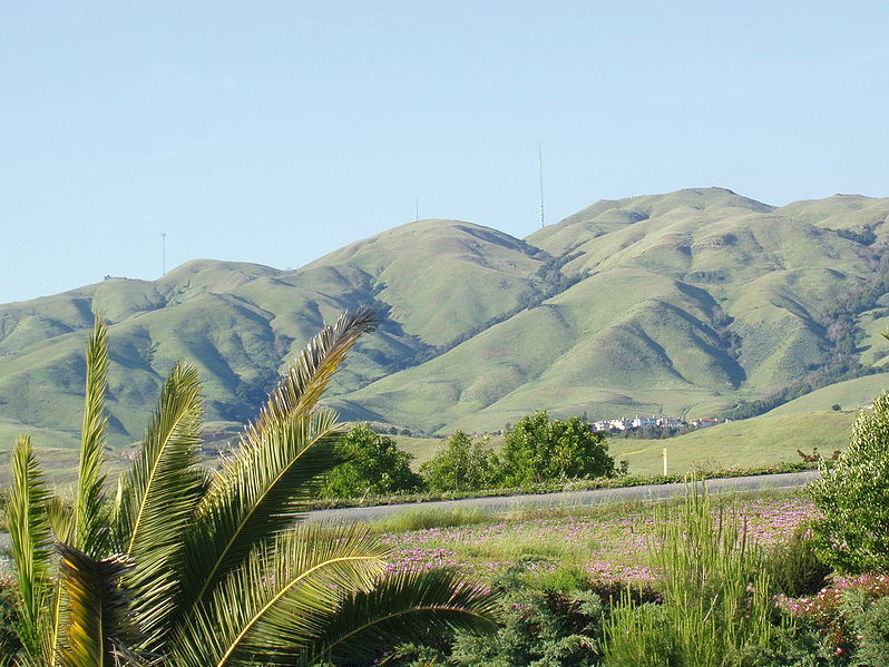
Looking east toward Monument Peak in Milpitas, California. The rightmost (tallest) antenna is Monument Peak, while the leftmost one (second highest, with three "forks" visible) is Mount Allison. The small antenna in the center was recently built. The gully to the far right of the mountainside is Calera Creek. Just to its left is Scott Creek. Most of the area can be accessed via hking trails in Ed R. Levin County Park.
Going right - south. Going left is north. Mount Allison is about a mile north of Monument Peak.
The actual point of Monument Peak is the point lying directly right (south) of the tallest antenna (FCC structure 1019291).
Notice Mount Allison's antenna - it has three "forks" on the top.
Can you see a few hiking trails leading up to Monument Peak?
The houses at the bottom of the mountains are the upper-class Calaveras Ridge Estates on Calaveras Ridge Road.
The hills are golden because of the dry summer season which dehydrates the grass on the hillsides. The hills are considered a high-risk fire hazard region.
| 本作品已被作者英语维基百科的Milpitas guy释出到公有领域。这适用于全世界。 在一些国家这可能不合法;如果是这样的话,那么: Milpitas guy无条件地授予任何人以任何目的使用本作品的权利,除非这些条件是法律规定所必需的。 |
.JPG)
文件历史
点击某个日期/时间查看对应时刻的文件。
| 日期/时间 | 缩略图 | 大小 | 用户 | 备注 | |
|---|---|---|---|---|---|
| 当前 | 2006年12月22日 (五) 15:33 | | 2,104 × 1,580(872 KB) | Nk | Looking east toward Monument Peak in Milpitas, California. The rightmost (tallest) antenna is Monument Peak, while the leftmost one (second highest, with three "forks" visible) is Mount Allison. The small antenna in the center was recently built. The gull |
文件用途
没有页面链接到本图像。
全域文件用途
以下其他wiki使用此文件:
- arz.wikipedia.org上的用途
- ceb.wikipedia.org上的用途
- de.wikipedia.org上的用途
- en.wikipedia.org上的用途
- eo.wikipedia.org上的用途
- es.wikipedia.org上的用途
- fr.wikipedia.org上的用途
- he.wikipedia.org上的用途
- ja.wikipedia.org上的用途
- lld.wikipedia.org上的用途
- pam.wikipedia.org上的用途
- uz.wikipedia.org上的用途
- www.wikidata.org上的用途