
File:Radar loop of Typhoon Haiyan (Yolanda) making landfall on Leyte Island.gif
本预览的尺寸:600 × 600像素。 其他分辨率:240 × 240像素 | 622 × 622像素。
原始文件 (622 × 622像素,文件大小:1.13 MB,MIME类型:image/gif、循环、19帧、9.5秒)
_making_landfall_on_Leyte_Island.gif?uselang=zh)
_making_landfall_on_Leyte_Island.gif?uselang=zh)
_making_landfall_on_Leyte_Island.gif?action=history&uselang=zh)
_making_landfall_on_Leyte_Island.gif)
摘要
| 描述 |
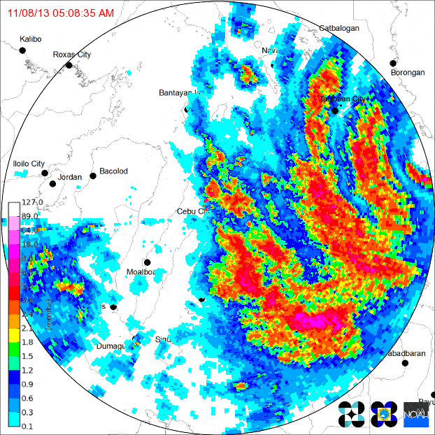
English: Loop of doppler radar imagery showing Typhoon Yolanda/Haiyan's second Philippine landfall, on the island of Leyte. The PAGASA Cebu City radar site began to transmit intermittently as the typhoon neared, eventually failing altogether (last frame).
|
| 日期 | |
| 来源 | http://www.pagasa.dost.gov.ph/ |
| 作者 | PAGASA |
许可协议
| 本作品位于菲律宾的公有领域,以及可能的其他司法管辖区,因为它是由以下机构的官员或雇员创作的作品菲律宾政府或其任何分部和机构,包括政府拥有和/或控制的公司,作为他的一部分定期规定的公务;因此,根据“第四部分第一章第171.11节”和“第四部分第四章第176节“第8293号共和国法和共和国法第10372号,经修订,除非另有说明。 但是,在某些情况下,在菲律宾或其他地方使用本作品可能受本法律或其他法律的约束。
|

|
文件历史
点击某个日期/时间查看对应时刻的文件。
| 日期/时间 | 缩略图 | 大小 | 用户 | 备注 | |
|---|---|---|---|---|---|
| 当前 | 2013年11月14日 (四) 10:40 | | 622 × 622(1.13 MB) | Chilledsunshine | compressed to acceptable size |
| 2013年11月14日 (四) 09:36 |  | 600 × 600(4.21 MB) | Chilledsunshine | User created page with UploadWizard |
文件用途
以下页面使用本文件:
全域文件用途
以下其他wiki使用此文件:
- de.wikipedia.org上的用途
- en.wikipedia.org上的用途
- ja.wikipedia.org上的用途
- tl.wikipedia.org上的用途
_making_landfall_on_Leyte_Island.gif)