
File:Relief map Pacific Electric Railway.jpg

本预览的尺寸:800 × 400像素。 其他分辨率:320 × 160像素 | 640 × 320像素 | 1,024 × 512像素 | 1,280 × 640像素 | 2,560 × 1,280像素 | 6,432 × 3,216像素。
原始文件 (6,432 × 3,216像素,文件大小:9.25 MB,MIME类型:image/jpeg)
摘要
| 描述 |
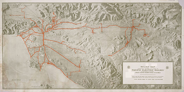
English: Relief map of territory served by lines of [the] Pacific Electric Railway in Southern California; largest electric railway system in the world
|
| 日期 | 约1920年 |
| 来源 | http://content.cdlib.org/ark:/13030/hb638nb72q/?layout=metadata |
| 作者 | Smith, O. A, Cartographer |
许可协议
此作品在美国属于公有领域,因为其是由美国政府的官员或雇员,基于其个人公务目的制作的作品,参考美国法典第17篇第1章第105条。
注意︰本模板仅适用于美国联邦政府的原创作品,不适用于任何美国州、属地、联邦个体、县、市或任何次级政府的作品。本模板也不适用于1978年以后由美国邮政署出版的邮票图案(参看美国版权局实践纲领第313.6(C)(1)条)。也不适用于部分美国硬币;参看美国铸币局使用条款。 |
 | |
| 本文件已被确认为免除已知的著作权法限制(包括所有相关权利)。 | ||
文件历史
点击某个日期/时间查看对应时刻的文件。
| 日期/时间 | 缩略图 | 大小 | 用户 | 备注 | |
|---|---|---|---|---|---|
| 当前 | 2014年9月3日 (三) 01:27 | | 6,432 × 3,216(9.25 MB) | Junkyardsparkle | Falling back to full/2 scale to unbreak thumbnail generation. |
| 2014年9月3日 (三) 01:08 |  | 12,864 × 6,432(18.79 MB) | Junkyardsparkle | Full resolution. | |
| 2014年8月27日 (三) 23:11 |  | 2,400 × 1,200(1.21 MB) | Junkyardsparkle | Higher resolution (names are legible at 1:1). | |
| 2007年6月24日 (日) 05:49 |  | 1,468 × 717(188 KB) | Nopira | from en:Image:Relief map Pacific Electric Railway.jpg http://ark.cdlib.org/ark:/13030/hb638nb72q/ Category:Los Angeles, California |
文件用途
全域文件用途
以下其他wiki使用此文件:
- en.wikipedia.org上的用途
- fr.wikipedia.org上的用途
- ja.wikipedia.org上的用途
- simple.wikipedia.org上的用途
- www.wikidata.org上的用途