
File:Rodrigues Island topographic map-fr.png
本预览的尺寸:637 × 600像素。 其他分辨率:255 × 240像素 | 510 × 480像素 | 816 × 768像素 | 1,088 × 1,024像素 | 1,700 × 1,600像素。
原始文件 (1,700 × 1,600像素,文件大小:874 KB,MIME类型:image/png)
摘要
| 相机位置 | | 在以下服务上查看本图像和附近其他图像: OpenStreetMap |
|---|
| 描述 |
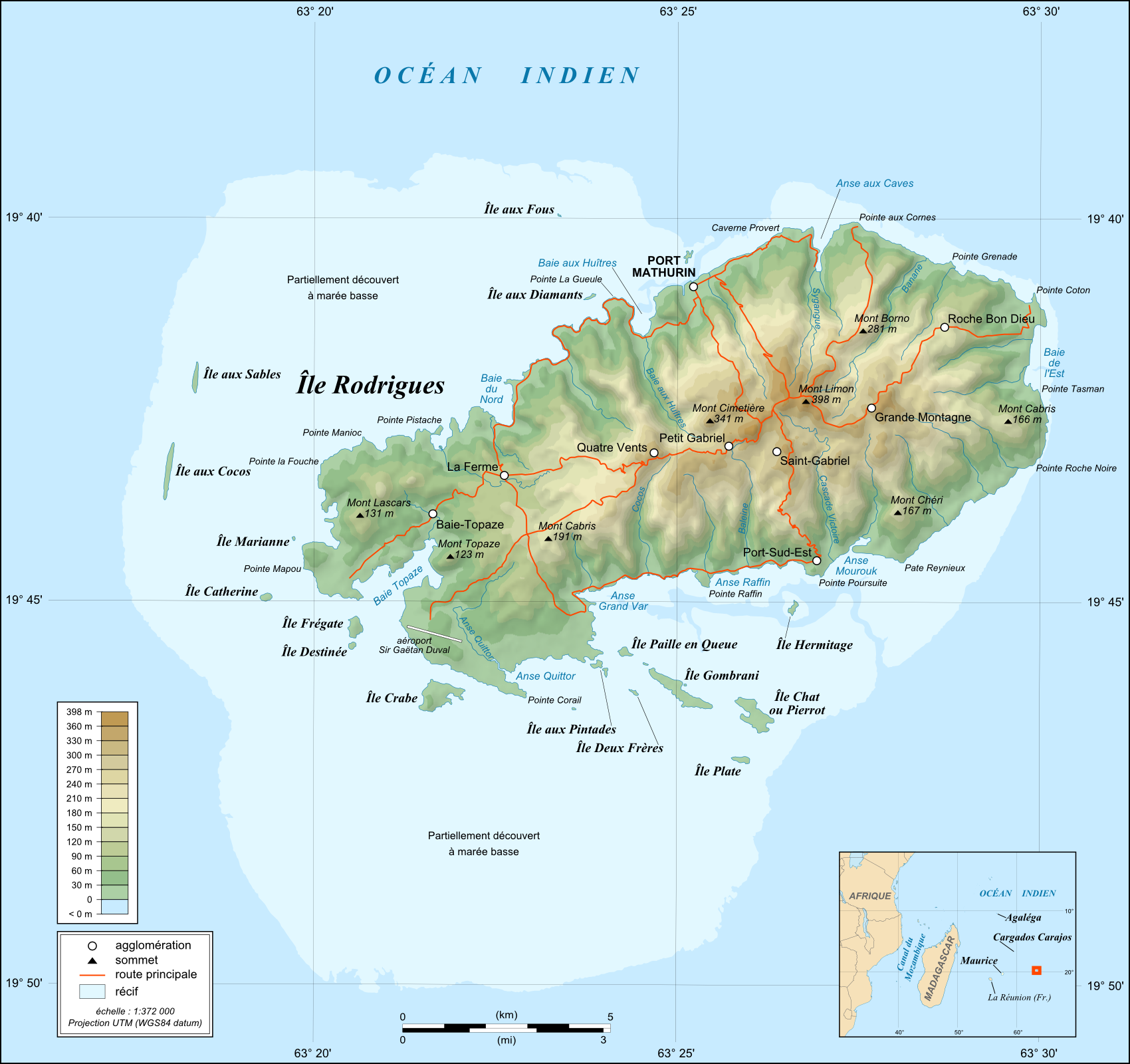
English: Topographic map in French of Rodrigues Island, Mauritius
Note : for translation purpose, use the SVG version Scale : 1:372,000 (accuracy : about 93 m) ; Printing size : 7.79 x 7.33 cm Français : Carte topographique en français de l'île de Rodrigues, Maurice
Échelle : 1:372 000 (précision : environ 93 m) ; Taille d'impression : 7,79 x 7,33 cm UTM projection, WGS84 datum
|
||
| 日期 | May 2008 (modified September 2008) | ||
| 来源 |
English: Own work (see complete description on Image:Rodrigues_Island_topographic_map-fr.svg).
Français : Création personnelle (voir description complète sur Image:Rodrigues_Island_topographic_map-fr.svg). |
||
| 作者 | Eric Gaba (Sting - fr:Sting) | ||
| 授权 (二次使用本文件) |
|
||
| 其他版本 |
[]
|


许可协议
我,本作品著作权人,特此采用以下许可协议发表本作品:

|
已授权您依据自由软件基金会发行的无固定段落及封面封底文字(Invariant Sections, Front-Cover Texts, and Back-Cover Texts)的GNU自由文件许可协议1.2版或任意后续版本的条款,复制、传播和/或修改本文件。该协议的副本请见“GNU Free Documentation License”。 |
This file is licensed under the Creative Commons Attribution-Share Alike 4.0 International, 3.0 Unported, 2.5 Generic, 2.0 Generic and 1.0 Generic license.
- 您可以自由地:
- 共享 – 复制、发行并传播本作品
- 修改 – 改编作品
- 惟须遵守下列条件:
- 署名 – 您必须对作品进行署名,提供授权条款的链接,并说明是否对原始内容进行了更改。您可以用任何合理的方式来署名,但不得以任何方式表明许可人认可您或您的使用。
- 相同方式共享 – 如果您再混合、转换或者基于本作品进行创作,您必须以与原先许可协议相同或相兼容的许可协议分发您贡献的作品。
您可以选择您需要的许可协议。
文件历史
点击某个日期/时间查看对应时刻的文件。
| 日期/时间 | 缩略图 | 大小 | 用户 | 备注 | |
|---|---|---|---|---|---|
| 当前 | 2010年7月19日 (一) 13:41 | | 1,700 × 1,600(874 KB) | Sting | Color profile |
| 2008年9月6日 (六) 02:43 |  | 1,700 × 1,600(814 KB) | Sting | Adding roads and other labels ; new standard colors | |
| 2008年5月14日 (三) 03:55 |  | 1,700 × 1,600(706 KB) | Sting | == Summary == {{Location|19|43|00|S|63|25|00|E|scale:200000}} <br/> {{Information |Description={{en|Topographic map in French of Rodrigues Island, Mauritius<br/>''Note :'' for translation purpose, use the [[:Ro |
文件用途
以下页面使用本文件:
全域文件用途
以下其他wiki使用此文件:
- de.wikipedia.org上的用途
- es.wikipedia.org上的用途
- fr.wikipedia.org上的用途
- gl.wikipedia.org上的用途
- mt.wikipedia.org上的用途
- no.wikipedia.org上的用途
- ro.wikipedia.org上的用途
- sr.wikipedia.org上的用途
- uk.wikipedia.org上的用途