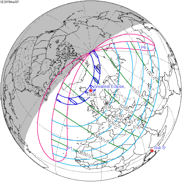
File:SE2015Mar20T.png

本预览的尺寸:599 × 600像素。 其他分辨率:240 × 240像素 | 479 × 480像素 | 728 × 729像素。
原始文件 (728 × 729像素,文件大小:27 KB,MIME类型:image/png)
文件历史
点击某个日期/时间查看对应时刻的文件。
| 日期/时间 | 缩略图 | 大小 | 用户 | 备注 | |
|---|---|---|---|---|---|
| 当前 | 2015年7月16日 (四) 18:22 |  | 728 × 729(27 KB) | Cmdrjameson | Compressed with pngout. Reduced by 62kB (70% decrease). |
| 2011年8月9日 (二) 08:40 |  | 728 × 729(89 KB) | OgreBot | (BOT): Reverting to most recent version; originally uploaded at en.wikipedia on 2009-12-08 20:37:41 by SockPuppetForTomruen | |
| 2011年8月9日 (二) 08:40 |  | 733 × 729(89 KB) | OgreBot | (BOT): Uploading old version of file from en.wikipedia; originally uploaded on 2009-11-22 07:43:35 by Tomruen | |
| 2011年3月13日 (日) 10:13 |  | 728 × 729(89 KB) | SamZane | {{Information |Description ={{en|1=Solar eclipse of march 20 2015 map.}} |Source =NASA |Author =NASA |Date = |Permission = |other_versions = }} Category:Solar eclipse map |
文件用途
以下19个页面使用本文件:
- 1907年1月14日日食
- 1925年1月24日日食
- 1943年2月4日日食
- 1961年2月15日日食
- 1979年2月26日日食
- 1997年3月9日日食
- 2011年6月1日日食
- 2015年3月20日日食
- 2015年9月13日日食
- 2016年3月9日日食
- 2016年9月1日日食
- 2017年2月26日日食
- 2017年8月21日日食
- 2018年2月15日日食
- 2018年8月11日日食
- 2033年3月30日日食
- Template:Solar Metonic series 2011 June 1
- Template:Solar Saros series 120
- Template:Solar eclipse set 2015-2018
全域文件用途
以下其他wiki使用此文件:
- ar.wikipedia.org上的用途
- كسوف الشمس 20 مارس 2015
- كسوف الشمس 1 يونيو 2011
- كسوف الشمس 1 سبتمبر 2016
- كسوف الشمس 26 فبراير 2017
- كسوف الشمس 25 أكتوبر 2022
- كسوف الشمس 12 أغسطس 2026
- كسوف الشمس 30 مارس 2033
- كسوف الشمس 5 يناير 2038
- كسوف الشمس 25 أكتوبر 2041
- كسوف الشمس 12 أغسطس 2045
- كسوف الشمس 31 مايو 2049
- كسوف الشمس 11 أبريل 2051
- كسوف الشمس 20 مارس 2034
- كسوف الشمس 20 مارس 2053
- كسوف الشمس 12 أغسطس 2064
- كسوف الشمس 5 يناير 2057
- كسوف الشمس 24 أكتوبر 2060
- كسوف الشمس 31 مايو 2068
- كسوف الشمس 21 أبريل 2069
- كسوف الشمس 6 يناير 2019
- كسوف الشمس 2 مايو 2087
- كسوف الشمس 1 يونيو 2087
- كسوف الشمس 19 مارس 2072
- كسوف الشمس 7 فبراير 2073
- كسوف الشمس 3 أغسطس 2073
- كسوف الشمس 27 يناير 2074
- كسوف الشمس 6 يناير 2076
- كسوف الشمس 24 أكتوبر 2079
- كسوف الشمس 21 مارس 2080
- كسوف الشمس 13 سبتمبر 2080
- كسوف الشمس 10 مارس 2081
- كسوف الشمس 13 أغسطس 2083
- كسوف الشمس 7 يناير 2084
- كسوف الشمس 3 يوليو 2084
- كسوف الشمس 27 ديسمبر 2084
- كسوف الشمس 22 يونيو 2085
- كسوف الشمس 16 ديسمبر 2085
- az.wikipedia.org上的用途
- be.wikipedia.org上的用途
- bg.wikipedia.org上的用途
- bn.wikipedia.org上的用途
- el.wikipedia.org上的用途
- en.wikipedia.org上的用途
查看本文件的更多全域用途。


