
File:The Blue Marble.jpg

本预览的尺寸:578 × 600像素。 其他分辨率:231 × 240像素 | 463 × 480像素 | 740 × 768像素 | 987 × 1,024像素 | 2,320 × 2,407像素。
原始文件 (2,320 × 2,407像素,文件大小:2.33 MB,MIME类型:image/jpeg)
Taken with a Hasselblad 500EL camera and 80mm Zeiss lens at stop setting f/2.8 on 70mm Ektachrome film of type SO-368
| 藍色彈珠
|
||
|---|---|---|
| 作者 |
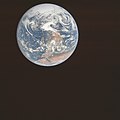
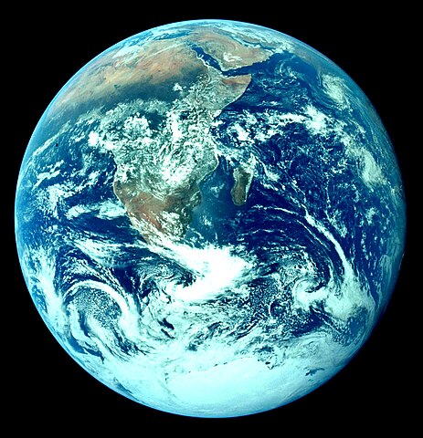
The photo was taken by the crew of Apollo 17 on their way to the Moon. Antarctica, Africa, the Arabian Peninsula, Madagascar, and part of Asia are visible.
|
.jpg) |
| 攝影師 | ||
| 标题 |
英语: The Blue Marble 《藍色彈珠》 |
|
| 所属实体 |
阿波罗17号 |
|
| 物体类型 |
相片 |
|
| 藝術類型 |
天文攝影 |
|
| 描述 |
A version of The Blue Marble. |
|
| 日期 | This image was originally uploaded to the English Wikipedia by Deglr6328 on 04:05, 8 Mar 2005. | |
| 来源 | The image is from [1] (NASA mission AS17, roll 148, frame 22727), specifically the 4400x4600 version available there. | |
| 其他版本 |
|
|


.jpg)
| 物体位置 | | 在以下服务上查看本图像和附近其他图像: OpenStreetMap |
|---|
Other versions
[]
Other versions:
-
 Raw photograph, AS17-148-22727, original orientation
 -
 Raw photograph, AS17-148-22727, north up
 -
 Rescanned and color-calibrated with mission color chart.
3,000×3,000 (5.6 MB) -
 With white background
2,790×2,776 (4.4 MB) -
 With transparent background
2,790×2,776 (14.64 MB) -
 Larger photoshopped JPEG version; possibly more useful for articles
4,463×4,163 (5.9 MB) -
 Color corrected
2,320×2,407 (2.33 MB) -
 Image redone with colors
2,400x2,400 (3.33 MB) -
 Reversed (allegedly original) orientation
3,000×3,002 (9.33 MB) -
 '"The Blue Marble" is a famous photograph of the Earth'
2,400x2,400 (2.98 MB)
.jpg)


.jpg)


Derivative works:
-
 earth
earth
600x600 (1.72 MB) -
 GPS atmospheric effects for the Earth
 -
 Universal gravitational mass for the Earth
 -
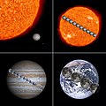 Order of magnitude for the Sun, Jupiter, Earth, and Moon
 -
 Earth size comparison for the Moon
 -
 Earth size comparison for the planet Venus
 -
 Earth and Moon to scale with annotations
 -
 Earth-Moon system to scale
 -
 Origin of life stages


许可协议
| 本文件完全由NASA创作,在美国属于公有领域。根据NASA的版权方针,NASA的材料除非另有声明否则不受版权保护。(参见Template:PD-USGov/zh、NASA版权方针页面或JPL图片使用方针。) | ||
 |
警告:
|
文件历史
点击某个日期/时间查看对应时刻的文件。
| 日期/时间 | 缩略图 | 大小 | 用户 | 备注 | |
|---|---|---|---|---|---|
| 当前 | 2023年10月28日 (六) 09:52 | | 2,320 × 2,407(2.33 MB) | Mykhal | original significat historical photo was corrected in place, while there are corrected derivatives as separate related photos - Reverted to version as of 22:13, 20 March 2005 (UTC) |
| 2011年12月7日 (三) 05:11 |  | 3,000 × 3,002(6.69 MB) | Ultimate Roadgeek | The old version seemed too cyan-heavy. | |
| 2005年3月20日 (日) 22:13 |  | 2,320 × 2,407(2.33 MB) | Dbenbenn | different color version of Image:The Earth seen from Apollo 17.jpg |
文件用途
以下18个页面使用本文件:
- 宇宙速度
- User:Bbbaina/TWA/Earth/2
- User:BrianCho/TWA/Earth/2
- User:FishaChang/TWA/Earth/2
- User:Geistory317/TWA/Earth/2
- User:ItsLiana/TWA/Earth/2
- User:ItsYifeiSun/TWA/Earth/2
- User:Jacklamf1d14/TWA/Earth/2
- User:Jade Luo/TWA/Earth/2
- User:Pash97143/TWA/Earth/2
- User:SilverElprup18/TWA/Earth/2
- User:SingBow/TWA/Earth/2
- User:WOLRDMINIMUM/TWA/Earth/2
- User:WangZitong1203/TWA/Earth/2
- User:WeCanChat/TWA/Earth
- User:Zhongshukaerka/TWA/Earth/2
- User:蘿蔔糕柯南/TWA/Earth/2
- User:食油猫饼的蟹鼠/TWA/Earth/2
全域文件用途
以下其他wiki使用此文件:
- ar.wikipedia.org上的用途
- avk.wikipedia.org上的用途
- ca.wikipedia.org上的用途
- Usuari:ESM/Bus/Terra/2
- Usuari:Unapersona/Bus/Terra/2
- Usuari:Fnac.fnac/Bus/Terra/2
- Usuari:Klasky/Bus/Terra/2
- Usuari:AFG/Bus/Terra/2
- Usuari:Biblioteca Pública Maria Barbal/Bus/Terra/2
- Usuari:Jordiemporda/Bus/Terra/2
- Usuari:Girka/Bus/Terra/2
- Usuari:UllDistret/Bus/Terra/2
- Usuari:Martakarta/Bus/Terra/2
- Usuari:Anskar/Bus/Terra/2
- Usuari:RamonLechado/Bus/Terra/2
- Usuari:JordiPE/Bus/Terra/2
- Usuari:Mikicat/Bus/Terra/2
- Usuari:Sorbete/Bus/Terra/2
- Usuari:Bloguer/Bus/Terra/2
- Usuari:Marianna Amill/Bus/Terra/2
- Usuari:Cristinariera/Bus/Terra/2
- Usuari:LaiaBT/Bus/Terra/2
- Usuari:O liva cm/Bus/Terra/2
- Usuari:Bpalleja/Bus/Terra/2
- Usuari:Paputx/Bus/Terra/2
- Usuari:Robert Jové/Bus/Terra/2
- Usuari:Rosamariavalles/Bus/Terra/2
- Usuari:Cgranadino/Bus/Terra/2
- Usuari:Geotu8/Bus/Terra/2
- Usuari:Carme.trabal/Bus/Terra/2
- Usuari:Fernandezmoj/Bus/Terra/2
- Usuari:Patrícia13tretze/Bus/Terra/2
- Usuari:Tonivmp/Bus/Terra/2
- Usuari:Bgavajsv/Bus/Terra/2
- Usuari:Tiputini/Bus/Terra/2
- Usuari:Josep.anton.fernandez/Bus/Terra/2
查看本文件的更多全域用途。