加拿大北部
座標:65°49′12″N 107°04′48″W / 65.82000°N 107.08000°W
| 此條目沒有列出任何參考或來源。 (2018年2月11日) |


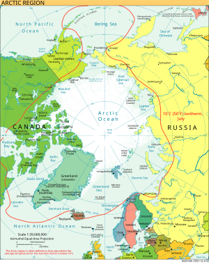
加拿大北部是在地理和政治上定義的加拿大北部地區,通常包括育空、西北地區和努納武特三個地區,都在北極圈附近,並包括北極點。由於加拿大人口集中在南部美加邊境附近,所以傳統上加拿大沒有南部的概念與加拿大北部相對應,因為加拿大北部的定義通常與加拿大北極地區重合。
領土[編輯]

從1925年開始,加拿大申明西經60°W到141°W的北極領土為其所有。
參見[編輯]
外部連結[編輯]
| 維基共享資源上的相關多媒體資源:加拿大北部 |
- Honderich, John. Arctic Imperative: Is Canada Losing the North? Toronto, Ont.: University of Toronto Press, 1987. xi, 258 p., ill. in b&w with charts, maps, and photos. ISBN 0-8020-5763-2
- Mowat, Farley. Canada North, in series, The Canadian Illustrated Library. Toronto: McClelland and Stewart, 1967. 127, [1] p., copiously ill. in b&w and col.
- Canada Year Book 1967 (PDF). Ottawa, Canada: Statistics Canada. 1967: 57–63 [6 March 2015]. (原始內容存檔 (PDF)於2016-10-13).
