
萊恩縣 (堪薩斯州)
(重新導向自雷恩縣 (堪薩斯州))
| 萊恩縣 Lane County | |
|---|---|
| 縣 | |
 萊恩縣法院 | |
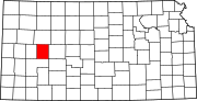
 萊恩縣於堪薩斯州中的位置 | |
 堪薩斯州於美國的位置 | |
| 坐標:38°28′00″N 100°28′01″W / 38.4667°N 100.467°W | |
| 國家 | |
| 州 | |
| 設立日期 | 1873年3月20日 |
| 語源 | 詹姆斯·亨利·萊恩 |
| 縣治 | 戴頓 |
| 最大城市 | 戴頓 |
| 面積 | |
| • 總計 | 718 平方英里(2,000 平方公里) |
| • 陸地 | 717 平方英里(2,000 平方公里) |
| • 水域 | 0.2 平方英里(0.5 平方公里) 0.03%% |
| 人口(2020年)[1] | |
| • 總計 | 1,574人 |
| • 估計(2021年)[2] | 1,565 ▼ |
| • 密度 | 2.2人/平方英里(0.8人/平方公里) |
| 時區 | 中部時區(UTC−6) |
| • 夏時制 | 中部時區(UTC−5) |
| 包含的國會選區 | 第一國會選區 |
| 網站 | lanecountyks.org |
萊恩縣(英語:Lane County,簡寫為LE)是位於美國堪薩斯州的縣。根據2020年人口普查顯示,該縣人口為1,574人[1],是該州人口第三少的縣。萊恩縣的縣治為戴頓[3],亦是該縣唯一的城市。萊恩縣得名於廢奴主義運動組織盜巢鷹的領導人詹姆斯·亨利·萊恩,此人後來成為了堪薩斯州首位聯邦參議員之一。[4]
人口[編輯]
| 歷史人口數 | |||
|---|---|---|---|
| 調查年 | 人口 | %± | |
| 1880年 | 604 | — | |
| 1890年 | 2,060 | 241.1% | |
| 1900年 | 1,563 | −24.1% | |
| 1910年 | 2,603 | 66.5% | |
| 1920年 | 2,848 | 9.4% | |
| 1930年 | 3,372 | 18.4% | |
| 1940年 | 2,821 | −16.3% | |
| 1950年 | 2,808 | −0.5% | |
| 1960年 | 3,060 | 9.0% | |
| 1970年 | 2,707 | −11.5% | |
| 1980年 | 2,472 | −8.7% | |
| 1990年 | 2,375 | −3.9% | |
| 2000年 | 2,155 | −9.3% | |
| 2010年 | 1,750 | −18.8% | |
| 2020年 | 1,574 | −10.1% | |
| 2021年估計 | 1,565 | [2] | −10.6% |
| 美國十年一次的人口普查[5] 1790-1960[6] 1900-1990[7] 1990-2000[8] 2010-2020[1] | |||

參考文獻[編輯]
- ^ 1.0 1.1 1.2 QuickFacts; Lane County, Kansas; Population, Census, 2020 & 2010. United States Census Bureau. [2021-08-17]. (原始內容存檔於2021-08-17).
- ^ 2.0 2.1 Annual Estimates of the Resident Population for Counties: April 1, 2020 to July 1, 2021. [2022-10-23]. (原始內容存檔於2022-03-24).
- ^ Find a County. National Association of Counties. [2011-06-07]. (原始內容存檔於2011-05-31).
- ^ Gannett, Henry. The Origin of Certain Place Names in the United States. Government Printing Office. 1905: 180.
- ^ U.S. Decennial Census. United States Census Bureau. [2014-07-26]. (原始內容存檔於2015-04-26).
- ^ Historical Census Browser. University of Virginia Library. [2014-07-26]. (原始內容存檔於2019-09-01).
- ^ Population of Counties by Decennial Census: 1900 to 1990. United States Census Bureau. [2014-07-26]. (原始內容存檔於2019-06-05).
- ^ Census 2000 PHC-T-4. Ranking Tables for Counties: 1990 and 2000 (PDF). United States Census Bureau. [2014-07-26]. (原始內容存檔 (PDF)於2010-03-27).
| |||||||||||||||||||||||||
| ||||||||||||||||||||||||||||||||||||||||

| ||||||||||||
| 這是一篇與堪薩斯州相關的小作品。你可以透過編輯或修訂擴充其內容。 |