
38度線
| 南北韓軍事分界線 | |
|---|---|
| 朝鮮半島 | |
 南北韓軍事分界線地圖,非軍事區以紅色標示,雙方軍事分界線(MDL)即為非軍事區中間的黑線,白色的點為北韓挖掘穿過軍事分界線的隧道。 | |
| 類型 | 軍事分界線 |
| 設施資訊 | |
| 控制者 | (1953年-1958年) |
| 公眾開放 | 除板門店外,外人無法穿越。 |
| 現狀 | 絕大部分線段被地雷區隔絕,有數條公鐵路線穿越。 |
| 歷史 | |
| 建於 | 1953年7月27日起 |
| 建造者 | |
| 使用時期 | 1953年7月27日 |
| 戰役 | 韓戰 |
| 駐軍狀態 | |
| 派駐部隊 | |
| 38度線 | |
| 諺文 | 삼팔선 |
|---|---|
| 漢字 | 三八線 |
| 文觀部式 | Sampalseon |
| 馬-賴式 | Samp'alsŏn |
38度線,是1945年盟軍託管朝鮮時期,蘇聯和美國在從日本手中接收朝鮮半島過程中,按土地面積大致相等原則,沿北緯38度線在地圖上劃定的一條受降分界線。值得注意的是,該線嚴格上並非停戰分界線,朝鮮民主主義人民共和國(北韓)和大韓民國(南韓)雙方的現有界線是根據1953年《朝鮮停戰協定》劃設的軍事分界線(又稱作停戰線)。
根據北韓停戰協議規定,兩韓之間以全長247公里(153英里)的實際控制區劃定界線;例如戰後由北韓實際控制的開城市就位於北緯38度以南。由此該線雖是大致依照北緯38度線劃定,但主要是根據雙方於1953年韓戰停戰時的實際控制線,而軍事分界線兩側即是南北韓非軍事區[1]。
由於兩韓均宣稱擁有朝鮮半島全境主權,因此這條軍事分界線並不被雙方視為「國界」。在黃海上,兩韓以事實上的「海上軍事劃界線」分隔,稱為北方界線,由聯合國軍於1953年劃定[2]。然而北方界線並未有在停戰協定中提及,因此不被北韓承認[3]。
歷史[編輯]

1896年5月,俄羅斯帝國皇帝尼古拉二世加冕。1896年6月,前日本內閣總理大臣山縣有朋和俄國外交大臣羅拔諾甫簽訂羅拔諾甫-山縣協議,會談中兩國曾按38線平分朝鮮半島,但大韓帝國仍作為大日本帝國的保護國。但是,1904年日俄戰爭後,日本獨吞朝鮮半島[4]。
1945年日本撤消朝鮮軍編制時,便是依照此線將38度線以北的朝鮮軍併入關東軍,38度線以南的朝鮮軍併入國內軍。
第二次世界大戰結束時,美國和蘇聯在朝鮮半島商定以北緯38度線作為接受日本投降的範圍界限,北部為蘇軍受降區,南部為美軍受降區。蘇美以北緯38度線劃界分別對日軍受降,與日軍45年內部編制劃分無關。1945年8月7日夜,蘇聯對日宣戰,8月15日昭和天皇宣布日本無條件投降,當時蘇軍正在東亞大陸上迅速擴大著占領區,而美軍此時尚分布於太平洋以西諸多島嶼上。美國認為有必要在東亞大陸上尋求一個支點,決定向蘇聯提出由美軍占領一半的朝鮮半島,鑑於蘇軍的推進速度,這個提議需儘快以蘇聯不易拒絕的方式提出,於是美軍上校迪安·里斯克以地圖為準選擇了北緯38度線簡單地將朝鮮半島分為土地面積大致相等的兩個受降區。美方提出以北緯38度線為分界線的理由,一是便於地圖上定位和查找,二是為避免因土地面積得失導致蘇方否決或反悔,有意給北方多留了些土地面積,所以38線以北實際擁有朝鮮半島約57%的土地面積、38線以南擁有約43%,蘇方立即接受,因為蘇聯同時也有意圖在日本本土尋求一個支點,即打算由蘇軍占領北海道,但這個意圖在雙方倉促決定38線劃分時沒來得及作為附帶條件,而是之後另外提出的,並被美國拒絕。兩周後的1945年9月8日、9日,美軍分別在釜山、仁川地區登陸,此前蘇軍先導部隊曾抵達京城(今首爾),鑑於雙方的協議,又退回38線以北。
38線的劃分是時間緊迫下的倉促決定,絲毫沒有考慮地理人文因素,軍事經濟利弊,沒有實地測量歷史借鑑。其實,即使美方最初以北緯37度或39度線劃分,也沒有太大差異,因為這僅是一條受降分界線,時效作用都有限,如美蘇並未以38線為界,禁止朝鮮半島上居民的往來,到了1948年也沒有以38線為界區分南北韓,而是分別只承認單一的一國。對蘇美來說,毫無理由要考察日俄戰爭或延續日軍的內部劃分標準,日俄戰爭戰爭說和關東軍國內軍說不過是試圖提升38線的地位和認可程度,以為某些論斷鋪墊。而半島直接利益者南北韓雙方歷來都沒有承認38線為自己主權邊緣。
然而兩大陣營隨即因理念不同,在之後北韓的政治路線上出現了糾紛。1948年,南部決定成立國會,以選舉來票選總統,在北方未參加和南方濟州四·三事件彈壓下,進而成立創建了大韓民國,留美的李承晚博士通過選舉成為大韓民國總統。流亡蘇聯的抗日游擊隊長金日成在蘇聯支持下,也自行於朝鮮半島北部蘇占區上宣布建立朝鮮民主主義人民共和國,金日成成為北韓內閣首相。南北韓先後成立國家,雙方均認為擁有朝鮮半島全境,並各自在蘇、美占領軍的支持下建立政權。
1949年初蘇聯撤軍,將北方主權交給朝鮮民主主義人民共和國,數月後美國撤軍,將南方主權交給大韓民國,雙方自1949年起頻繁發生小型武裝衝突,並逐漸封鎖了南北居民的自由往來,所以38度線成為南北韓兩國實際統治區的界線。
1950年6月25日,韓戰爆發,隨後朝鮮人民軍大舉南下。北韓宣稱當日南韓國軍於當日拂曉在38度線(按:北緯三十八度為南北韓的交界線)全線向北朝鮮發動了意外的進攻,在黃海道的海州西部地區、金川地區、江原道的鐵原地區,三路侵入北朝鮮一公里至二公里。[5][6][7]南韓則駁斥北韓說法,宣稱朝鮮人民軍先入侵[8][9][10],並在北韓大軍入侵後宣布了反擊海州的消息,南韓在海州的反擊戰有6月26日美聯社[11]、合眾社、路透社[12]、《泰晤士報》、《曼切斯特衛報》、《每日電訊報》、《每日先驅報》、《芝加哥論壇報》佐證[13][14],但此後南韓政府宣布反攻海州為假新聞並將其歸咎於一名誇大其詞的官員。[15][16] 而中國一直認為,南朝鮮軍隊先越過38度線,而北朝鮮是被進攻方[17]。美軍和聯合國軍分別於7月5日和7月7日開始武力介入韓戰,中國於10月19日在平壤被攻陷後,也加入了韓戰。事實上,當時38線並不受南北韓雙方重視,互有滲透及交火。
1953年韓戰結束後,停戰界線大致上仍沿38度線自東至西橫貫朝鮮半島;出於便於定位考慮,中文裡某些非正式場合習慣將其稱為「38度線」,正式場合則不然。
-
 朝鮮人民軍哨點
 -
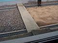 軍事分界線,右側為北韓領土,左側為南韓領土
 -
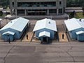 中立區建築物
 -
 會議室外的朝鮮人民軍衛兵
 -
 1997年的界線會談
 -
 雙方衛兵哨點相距僅5公尺
 -
 西方人在北韓一側會議室觀光


.jpg)
現況[編輯]
2007年5月17日,京義線鐵路和東海線鐵路試運行,這是56年來首次有列車跨越南北韓軍事分界線[18]。
2007年10月2日,南韓總統盧武鉉徒步走過軍事分界線,是首位走過軍事分界線的南韓國家元首,亦是第二位訪問北韓的南韓總統(2000年金大中乘搭飛機訪問北韓)。
2017年11月13日,有一名朝鮮人民軍士兵投奔南韓,追截士兵有越過分界線向其射擊,聯合國軍司令部認為違反了南北韓休戰協定。
2018年4月27日的南北韓領導人會談,朝鮮勞動黨委員長、中央軍事委員會委員長兼朝鮮國務委員會委員長金正恩在板門店徒步走過軍事分界線會見大韓民國總統文在寅,這是首位走過軍事分界線的北韓最高領導人,亦是首位訪問南韓的北韓最高領導人。途中有個小插曲,文在寅問:「現在你已經來到南方,我何時可以到北方去呢?」,於是金正恩一把拉著文在寅跨過軍事分界線以示善意,但一度造成在場媒體及安保人員的驚慌。青瓦台稍後證實,兩人牽手跨越軍事分界線、到達板門店北韓側合影的行程,「並非事先安排」。[19]
2019年6月30日的美朝首腦會談,美國總統唐納·川普在板門店徒步越過三八線進入朝鮮民主主義人民共和國國境並與金正恩合照留念[20]。


參考文獻[編輯]
- ^ The MDL was defined and established in the Korean Armistice Agreement (KAA), Article I, paragraphs 1–11. The KAA includes provisions regarding the MDL and DMZ; but those provisions do not extend into the Yellow Sea or the Sea of Japan. The subsequently devised Northern Boundary Line or NLL (頁面存檔備份,存於網際網路檔案館) was neither initially conceived as part of the MDL, nor have the DPRK and UNC agreed to any subsequent extension of the MDL beyond the agreed upon limits of 1953/7/27.
- ^ Ryoo, Moo Bong. (2009). "The Korean Armistice and the Islands," (頁面存檔備份,存於網際網路檔案館) p. 5. Strategy research project at the U.S. Army War College; excerpt, "Strategic Consequences of the Agreement. The agreement to retain the five islands under UNC control has shaped many aspects of the security environment of the Korean Peninsula. The most obvious and prominent consequence is the establishment of the Northern Limit Line (NLL). The NLL has served as a practical maritime borderline and an effective means to separate the forces and thus prevent military clashes between th two Koreas"; compare Kim, Kwang-Tae. "After Exchange of Fire, N. Korea Threatens More Strikes on South," (頁面存檔備份,存於網際網路檔案館) Time (US). November 23, 2010.
- ^ Pak, Hŭi-gwŏn. (2000). The Law of the Sea and Northeast Asia: a Challenge for Cooperation, p. 108,第108頁,載於Google圖書; excerpt, "Under the 1953 Armistice Agreement, the Military Demarcation Line was drawn across the Korean peninsula. Since no maritime demarcation line was specified in the Armistice Agreement, however, the United Nations Command drew the NLL...."
- ^ 韩国媒体上演“口水战”. 世界博覽雜誌. 2010-12-16 [2010-12-19]. (原始內容存檔於2011-10-12).
- ^ 李承晚伪军向北朝鲜发动全线进攻 朝鲜共和国警备队展开防御战 朝鲜中央通讯社斥责战贩杜勒斯在南朝鲜的活动. 人民日報. 1950-06-26 [2019-10-02]. (原始內容存檔於2020-02-14) (中文(簡體)).
- ^ 北韩内务部发表公布反指南韩军首先进攻谓一切严重后果应由南韩负完全责任. 華僑日報. 1950-06-26 [2019-10-02]. (原始內容存檔於2020-11-03) (中文(繁體)).
- ^ [蘇聯}J.馬利克. 联合国安全理事会正式记录 第五年 第四八六次会议 一九五〇年八月十一日 第二十八号 纽约成功湖. 聯合國正式出版物. 1950-11-27 (中文(繁體)).
- ^ 联合国安全理事会正式记录 第五年第十五号 第四七三次会议 一九五〇年六月二十五日 纽约成功湖. 聯合國文件中心. (原始內容存檔於2020-07-25) (中文(繁體)).
- ^ 聯合國北韓問題委員會. Cablegram dated 25 June 1950 from the United Nations commission on Korea to the secretary-general concerning aggression upon the Republic of Korea. 聯合國文件中心. 1950-06-25. (原始內容存檔於2020-04-22) (英語).
- ^ 南韩外长发表声明 指摘北韩侵略 保安军决以全力抵抗. 華僑日報. 1950-06-26. (原始內容存檔於2020-11-03) (中文(繁體)).
- ^ 漢城二十六日美聯社電. 南韩军队反攻进入北韩五里 俘获坦克车有俄人. 香港工商晚報. 1950-06-26. (原始內容存檔於2021-02-05) (中文(繁體)).
- ^ 路透社東京廿六日電. 南军猛烈反攻 传克开城海州. 華僑日報. 1950-06-27. (原始內容存檔於2020-11-03) (中文(繁體)).
- ^ Karunakar Gupta. How Did the Korean War Begin?. The China Quarterly. 1972,. No. 52 (Oct. - Dec., 1972): pp. 699-716 (18 pages) [2019-10-02]. (原始內容存檔於2020-04-17).
- ^ ......The South Korean story of a counter-attack in the Haeju region is substantiated in a large number of western reports, datelined Seoul,26 June, and referring to events of the previous evening or still in progress. Thus the New York Times of the following day carried a story with this dateline, reporting that "according to the South Korean Office of Public Information," southern troops pushing northwards had captured Haeju. The British Daily Herald quoted American military observers in Seoul as saying that the South Korean forces had penetrated five miles into the North and seized Haeju. Lieutenant-Colonel Malonoy, Acting Chief of Staff of the U.S. Military Advisory Group, was reported to have summed up the situation in the following terms: By nightfall (of 25 June) all southern territory west of the Imjin river had been lost to a depth of at least three miles inside the border except in the area of the Haeju counter-attack. Similar reports were carried in the New York Herald Tribune, the Manchester Guardian, and many other British and American newspapers. ......The various accounts from Seoul all require us to suppose that the South Korean army was in a fit state to launch a counter-attack in the Haeju region, from the Ongjin area, in the late afternoon or evening of 25 June, after the North Korean attack which had commenced against the Ongjin Peninsula earlier in the same day. Was this a feasible operation,and was it consonant with the military situation on the ground in the evening of the 25th? Certainly such an operation could have been mounted early on the 25th by the 17th Regiment of the R.O.K. Capital Infantry Division under Colonel Paik In Yup with a fair chance of success, but were his forces still capable of offensive action by the time that the "counter-offensive" was supposedly launched? ......Moreover, early in the morning of the 26th, the South Korean Office of Public Information announced that Southern forces had indeed captured the North Korean town of Haeju. The announcement stated that the attack had occurred that same morning, but an American military status report as of nightfall on the 25th notes that all Southern territory west of the Imjin River had been lost to a depth of at least three miles inside the the attack had occurred that same morning. ---"How Did the Korean War Begin?", Karunakar Gupta
- ^ Blum, William Blum. Killing Hope: U.S. Military and C.I.A. Interventions since World War II. United States: Common Courage Press. 1995: 500 pp. ISBN 1-56751-253-4.
- ^ ......Moreover, early in the morning of the 26th, the South Korean Office of Public Information announced that Southern forces had indeed captured the North Korean town of Haeju. The announcement stated that the attack had occurred that same morning, but an American military status report as of nightfall on the 25th notes that all Southern territory west of the Imjin River had been lost to a depth of at least three miles inside the the attack had occurred that same morning.
......Subsequently, the South Korean government denied that its capture of Haeju had actually taken place, blaming the original announcement, apparently, on an exaggerating military officer. One historian has ascribed the allegedly incorrect announcement to "an error due to poor communications, plus an attempt to stiffen South Korean resistance by claiming a victory".
「Killing Hope」,William Blum - ^ 纪念朝鲜人民军建军十周年. 人民日報. 1958-02-08 [2012-06-22]. (原始內容存檔於2015-07-22).
- ^ 详讯:韩朝铁路中断56年后进行首次试运行. 新華網. 2007-05-17 [2007-05-18]. (原始內容存檔於2011-12-21).
- ^ Storm.mg. 「那我什麼時候可以到北韓?」「我現在帶你來吧!」在板門店展現靈活權變風采的金正恩-風傳媒. www.storm.mg. 2018-04-27 [2022-03-24]. (原始內容存檔於2019-05-13) (中文(臺灣)).
- ^ 美대통령 처음으로 북한 땅 밟다…남북미 정상 사상 첫 3자 회동. 韓聯社. 2019-06-30 [2019-06-30]. (原始內容存檔於2018-09-08) (韓語).
參見[編輯]
- 板門店
- 韓戰
- 北方界線
- 朝鮮半島和平條約
- JSA安全地帶-2000年南韓電影
- 南北韓非軍事區
- 共同警備區
- 南北韓高峰會
- 一七線
- 50度線
- 德國國內邊界
- 柏林圍牆
- 臺灣海峽中線
- 本初子午線
- 電視劇愛的迫降(韓語:사랑의불시착)