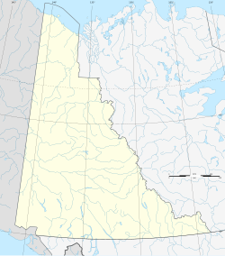
柏瓦什蘭丁
| 柏瓦什蘭丁 Burwash Landing | |
|---|---|
| 村莊 | |
 | |
| 坐標:61°21′22″N 138°59′24″W / 61.3561°N 138.99°W | |
| 國家 | 加拿大 |
| 地區 | |
| 人口(2006年) | |
| • 總計 | 73人 |
| 時區 | PST(UTC-8) |
| • 夏時制 | PDT(UTC-7) |
柏瓦什蘭丁(英語:Burwash Landing),加拿大育空領地的一個社區,位於庫魯阿尼湖南岸。該地總人口73人(2006年),大部分為原住民族。該地是庫魯阿尼族的行政中心。附近有柏瓦什機場。
地理[編輯]
柏瓦什蘭丁附近海拔807米。
氣候[編輯]
柏瓦什蘭丁有一個典型的亞寒帶濕潤性氣候(柯本氣候分類法為Dfc),接近亞寒帶季風氣候(柯本氣候分類法為Dwc)。2014年1月24日,柏瓦什蘭丁記錄了16.5 °C(61.7 °F)的高溫,這是育空地區1月的最高氣溫記錄[1]。此前的記錄是2013年1月13日在白馬市記錄的10.9 °C(51.6 °F)[2][3]。極端最高氣溫是31.7 °C(89.1 °F),在1969年6月14日紀錄,而極端最低氣溫是−55.0 °C(−67.0 °F),在2005年1月12日和1968年2月2日錄得。
| 柏瓦什機場(1981-2010年平均數據,1966年至今極端數據) | |||||||||||||
|---|---|---|---|---|---|---|---|---|---|---|---|---|---|
| 月份 | 1月 | 2月 | 3月 | 4月 | 5月 | 6月 | 7月 | 8月 | 9月 | 10月 | 11月 | 12月 | 全年 |
| 歷史最高濕熱指數 | 7.1 | 11.1 | 10.5 | 18.7 | 28.6 | 31.1 | 34.3 | 31.2 | 24.6 | 21.0 | 10.0 | 11.6 | 34.3 |
| 歷史最高溫 °C(°F) | 16.5 (61.7) |
12.0 (53.6) |
10.5 (50.9) |
20.3 (68.5) |
29.7 (85.5) |
31.7 (89.1) |
28.9 (84.0) |
30.5 (86.9) |
25.5 (77.9) |
21.0 (69.8) |
10.6 (51.1) |
13.5 (56.3) |
31.7 (89.1) |
| 平均高溫 °C(°F) | −14.3 (6.3) |
−8.8 (16.2) |
−2.3 (27.9) |
5.8 (42.4) |
12.7 (54.9) |
18.0 (64.4) |
19.6 (67.3) |
17.5 (63.5) |
11.3 (52.3) |
2.0 (35.6) |
−8.8 (16.2) |
−11.6 (11.1) |
3.4 (38.1) |
| 日均氣溫 °C(°F) | −20.5 (−4.9) |
−16.4 (2.5) |
−10.8 (12.6) |
−1.2 (29.8) |
5.7 (42.3) |
11.1 (52.0) |
13.1 (55.6) |
10.9 (51.6) |
5.1 (41.2) |
−3.4 (25.9) |
−14.6 (5.7) |
−17.8 (0.0) |
−3.2 (26.2) |
| 平均低溫 °C(°F) | −26.7 (−16.1) |
−23.8 (−10.8) |
−19.2 (−2.6) |
−8.2 (17.2) |
−1.4 (29.5) |
4.1 (39.4) |
6.4 (43.5) |
4.2 (39.6) |
−1.1 (30.0) |
−8.6 (16.5) |
−20.3 (−4.5) |
−24.0 (−11.2) |
−9.9 (14.2) |
| 歷史最低溫 °C(°F) | −55.0 (−67.0) |
−55.0 (−67.0) |
−48.9 (−56.0) |
−35.1 (−31.2) |
−13.0 (8.6) |
−5.5 (22.1) |
−3.3 (26.1) |
−8.5 (16.7) |
−22.3 (−8.1) |
−35.4 (−31.7) |
−44.7 (−48.5) |
−51.2 (−60.2) |
−55.0 (−67.0) |
| 歷史最低風寒指數 | −63.9 | −59.9 | −51.9 | −38.0 | −15.6 | −6.6 | −4.6 | −10.5 | −27.6 | −44.0 | −53.0 | −61.0 | −63.9 |
| 平均降水量 mm(英寸) | 8.4 (0.33) |
7.3 (0.29) |
6.9 (0.27) |
6.8 (0.27) |
24.1 (0.95) |
49.2 (1.94) |
67.9 (2.67) |
41.8 (1.65) |
25.2 (0.99) |
16.1 (0.63) |
10.8 (0.43) |
10.2 (0.40) |
274.7 (10.81) |
| 平均降雨量 mm(英寸) | 0.2 (0.01) |
0.1 (0.00) |
0.0 (0.0) |
0.8 (0.03) |
16.0 (0.63) |
47.9 (1.89) |
67.9 (2.67) |
41.0 (1.61) |
20.0 (0.79) |
2.0 (0.08) |
0.2 (0.01) |
0.0 (0.0) |
196.2 (7.72) |
| 平均降雪量 cm(英寸) | 12.0 (4.7) |
10.4 (4.1) |
9.9 (3.9) |
7.4 (2.9) |
8.8 (3.5) |
1.2 (0.5) |
0.0 (0.0) |
0.8 (0.3) |
5.9 (2.3) |
18.6 (7.3) |
15.8 (6.2) |
15.0 (5.9) |
105.5 (41.5) |
| 平均降水天數(≥ 0.2 mm) | 7.6 | 6.8 | 5.5 | 3.6 | 8.3 | 10.9 | 14.4 | 11.0 | 9.4 | 9.7 | 9.8 | 7.5 | 104.4 |
| 平均降雨天數(≥ 0.2 mm) | 0.1 | 0.2 | 0.0 | 0.5 | 6.6 | 10.9 | 14.4 | 10.8 | 7.7 | 1.7 | 0.2 | 0.1 | 53.2 |
| 平均降雪天數(≥ 0.2 cm) | 7.9 | 6.8 | 5.6 | 3.4 | 3.0 | 0.4 | 0.0 | 0.2 | 2.4 | 8.6 | 9.9 | 7.7 | 55.9 |
| 平均相對濕度(%) | 74.5 | 68.7 | 57.7 | 47.2 | 42.5 | 45.1 | 50.6 | 51.5 | 54.5 | 66.0 | 77.0 | 76.3 | 59.3 |
| 資料來源:1981-2010 Environment Canada[4] | |||||||||||||
人口統計[編輯]
根據2011年加拿大人口普查的數據,柏瓦什蘭丁共有人口95人,和2006年相比,人口增長了30.1%[5]。
| 年份 | 人口 | ±% |
|---|---|---|
| 1981 | 73 | — |
| 1986 | 64 | −12.3% |
| 1991 | 77 | +20.3% |
| 1996 | 58 | −24.7% |
| 2001 | 68 | +17.2% |
| 2006 | 73 | +7.4% |
| 2011 | 95 | +30.1% |
| 2016 | 72 | −24.2% |
| 2021 | — | |
| 來源:加拿大統計局 [6][7][8][9][10][5][11] | ||
參考文獻[編輯]
- ^ Historical Data for Burwash Landing Airport. Environment Canada. [2021-09-09]. Climate. (原始內容存檔於2022-01-19).
- ^ Current Weather Summaries for YT. Environment Canada. [2014-01-25]. Climate. (原始內容存檔於2022-08-03).
- ^ Historical Data for Burwash Landing Airport. Environment Canada. [2016-01-25]. Climate. (原始內容存檔於2022-01-19).
- ^ Burwash A (CSV (2874 KB)). Canadian Climate Normals 1981–2010. Environment Canada. [2014-02-20]. Climate ID: 2100182.[永久失效連結]
- ^ 5.0 5.1 Population and dwelling counts, for Canada, provinces and territories, and census subdivisions (municipalities), 2011 and 2006 censuses (Yukon). Statistics Canada. July 25, 2021 [January 30, 2022]. (原始內容存檔於2022-02-01).
- ^ 1986 Census: Population - Census Divisions and Census Subdivisions (PDF). Statistics Canada. September 1987 [January 30, 2022]. (原始內容存檔 (PDF)於2020-05-08).
- ^ 91 Census: Census Divisions and Census Subdivisions - Population and Dwelling Counts (PDF). Statistics Canada. April 1992 [January 30, 2022]. (原始內容存檔 (PDF)於2020-05-08).
- ^ 96 Census: A National Overview - Population and Dwelling Counts (PDF). Statistics Canada. April 1997 [January 30, 2022]. (原始內容存檔 (PDF)於2021-11-28).
- ^ Population and Dwelling Counts, for Canada, Provinces and Territories, and Census Subdivisions (Municipalities), 2001 and 1996 Censuses - 100% Data (Yukon Territory). Statistics Canada. August 15, 2012 [January 30, 2022]. (原始內容存檔於2022-02-01).
- ^ Population and dwelling counts, for Canada, provinces and territories, and census subdivisions (municipalities), 2006 and 2001 censuses - 100% data (Yukon Territory). Statistics Canada. August 20, 2021 [January 30, 2022]. (原始內容存檔於2022-01-22).
- ^ Population and dwelling counts, for Canada, provinces and territories, and census subdivisions (municipalities), 2016 and 2011 censuses – 100% data (Yukon). Statistics Canada. February 8, 2017 [January 30, 2022]. (原始內容存檔於2017-02-11).
外部連結[編輯]
| 維基共享資源上的相關多媒體資源:柏瓦什蘭丁 |
- Burwash Landing and Destruction Bay at the Government of Yukon
- tourist info
- Kluane First Nation(頁面存檔備份,存於網際網路檔案館)
| ||||||||||||||||||||||||||||||||||||||||||

