
File:Birkenau múzeum - panoramio (cropped).jpg

原始文件 (2,048 × 1,357像素,文件大小:875 KB,MIME类型:image/jpeg)
摘要
| 描述 |
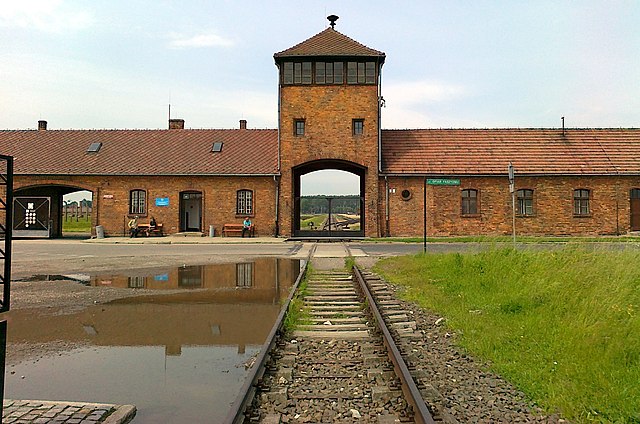
The gatehouse of Auschwitz II, also known as Auschwitz II-Birkenau, a Nazi German extermination camp in occupied Poland during the Holocaust. The building is preserved by the Auschwitz-Birkenau museum. This image shows the tracks from outside the camp leading through the gate to the third unloading ramp and the gas chambers. The first ramp was built in 1940 next to Auschwitz I, the main camp. The second ramp, the "Alte Judenrampe", was built in the Oświęcim freight station between Auschwitz I and Auschwitz II, and was used to receive mass transports of Jews and others until May 1944, when the third ramp was completed: "The third ramp was built from 1943 inside the Birkenau camp, and went into operation in May 1944 in connection with the anticipated arrival of transports of Hungarian Jews. The railroad spur along this ramp ran as far as gas chambers and crematoria II and III. Aside from the 430 thousand Hungarian Jews, 67 thousand Jews from the Łódź ghetto and some of the transports from the ghetto in Terezin and from Slovakia were unloaded at this ramp. From this point on, mass selections of Jews took place inside the camp, before the eyes of thousands of prisoners. Transports of Poles from Warsaw during the Uprising there, sent to Auschwitz by way of the transit camp in Pruszków, were also unloaded here" (Auschwitz-Birkenaum museum). |
||
| 日期 | 摄于2011年6月1日 | ||
| 来源 | https://web.archive.org/web/20161023024548/http://www.panoramio.com/photo/53636819 | ||
| 作者 | pzk net | ||
| 授权 (二次使用本文件) |
本文件采用知识共享署名 3.0 未本地化版本许可协议授权。 署名: pzk net
|
||
| 其他版本 | |||
| Tags (from Panoramio photo page) | Brzezinka, Birkenau múzeum |

.jpg?uselang=zh)
.jpg?uselang=zh)
.jpg?action=history&uselang=zh)
.jpg)
| 相机位置 | | 在以下服务上查看本图像和附近其他图像: OpenStreetMap |
|---|
.jpg¶ms=050.034660_N_0019.181316_E_globe:Earth_type:camera_source:Panoramio_&language=zh)
文件历史
点击某个日期/时间查看对应时刻的文件。
| 日期/时间 | 缩略图 | 大小 | 用户 | 备注 | |
|---|---|---|---|---|---|
| 当前 | 2019年10月12日 (六) 19:44 | | 2,048 × 1,357(875 KB) | SlimVirgin | == {{int:filedesc}} == {{Information |description=Birkenau múzeum |date={{Taken on|2011-06-01}} |source=https://web.archive.org/web/20161023024548/http://www.panoramio.com/photo/53636819 |author=[https://web.archive.org/web/20161023024551/http://www.panoramio.com/user/5960581?with_photo_id=53636819 pzk net] |permission={{cc-by-3.0|pzk net}} {{Panoramioreview|Panoramio_upload_bot|2016-11-25}} |other_versions={{extracted from|File:Birkenau múzeum - panoramio.jpg}} |other_fields={{Information fi... |
文件用途
以下页面使用本文件:
全域文件用途
以下其他wiki使用此文件:
- ary.wikipedia.org上的用途
- ast.wikipedia.org上的用途
- ban.wikipedia.org上的用途
- bn.wikipedia.org上的用途
- ckb.wikipedia.org上的用途
- cy.wikipedia.org上的用途
- en.wikipedia.org上的用途
- en.wikiquote.org上的用途
- en.wikivoyage.org上的用途
- eu.wikipedia.org上的用途
- fa.wikipedia.org上的用途
- ga.wikipedia.org上的用途
- gl.wikipedia.org上的用途
- he.wikipedia.org上的用途
- he.wikivoyage.org上的用途
- hy.wikipedia.org上的用途
- it.wikipedia.org上的用途
- it.wikibooks.org上的用途
- it.wikivoyage.org上的用途
- ko.wikipedia.org上的用途
- lb.wikipedia.org上的用途
- lt.wikipedia.org上的用途
- no.wikipedia.org上的用途
- pl.wikipedia.org上的用途
- pt.wikipedia.org上的用途
- ru.wikipedia.org上的用途
- ru.wikinews.org上的用途
- sk.wikipedia.org上的用途
- sl.wikipedia.org上的用途
- th.wikipedia.org上的用途
- uk.wikipedia.org上的用途
- uk.wikivoyage.org上的用途
- uz.wikipedia.org上的用途
- vec.wikipedia.org上的用途
查看此文件的更多全域用途。
.jpg)
.jpg)