
File:Mecklenburg-Vorpommern districts 2011 colored labeled Meck-Pomm-border.svg

此SVG文件的PNG预览的大小:800 × 549像素。 其他分辨率:320 × 220像素 | 640 × 439像素 | 1,024 × 703像素 | 1,280 × 879像素 | 2,560 × 1,757像素 | 1,129 × 775像素。
原始文件 (SVG文件,尺寸为1,129 × 775像素,文件大小:684 KB)
摘要
| 描述 |
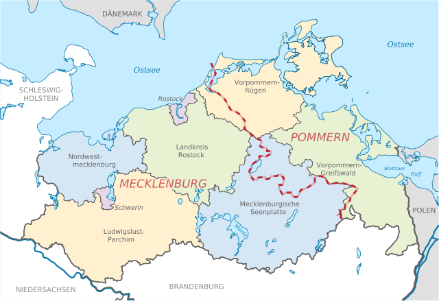
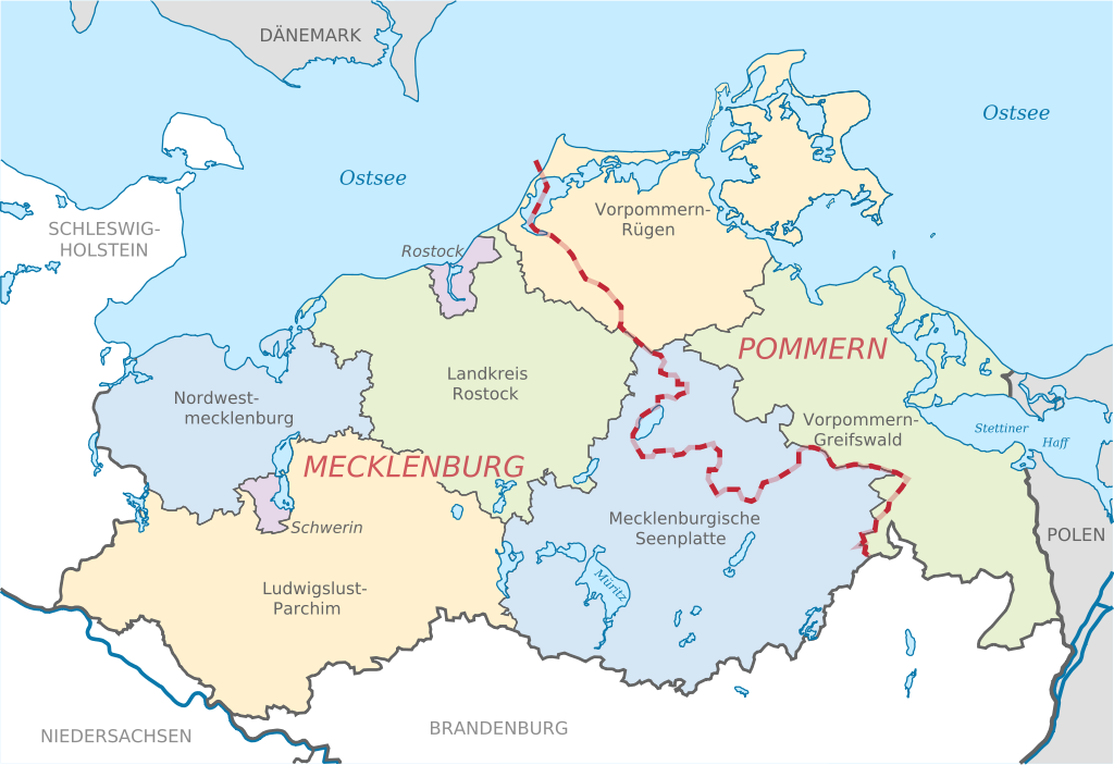
Deutsch: Karte mit Lage der Landkreise in Mecklenburg-Vorpommern, Deutschland nach der Kreisgebietsreform 2011. Eingezeichnet ist auch die Grenze zwischen den früheren Provinzen Pommern und Mecklenburg.
English: Locator map of counties in Mecklenburg-Vorpommern, Germany after county reorganization 2011. The red-white line indicates the former borders of the historical provinces Pommerania and Mecklenburg. |
| 日期 | |
| 来源 |
本W3C状态不明的矢量图使用Adobe Illustrator创作. 自己的作品, based on: |
| 作者 |
TUBS |
| 其他版本 |
|


许可协议
TUBS,本作品著作权人,特此采用以下许可协议发表本作品:

|
已授权您依据自由软件基金会发行的无固定段落及封面封底文字(Invariant Sections, Front-Cover Texts, and Back-Cover Texts)的GNU自由文件许可协议1.2版或任意后续版本的条款,复制、传播和/或修改本文件。该协议的副本请见“GNU Free Documentation License”。 |
署名: TUBS
- 您可以自由地:
- 共享 – 复制、发行并传播本作品
- 修改 – 改编作品
- 惟须遵守下列条件:
- 署名 – 您必须对作品进行署名,提供授权条款的链接,并说明是否对原始内容进行了更改。您可以用任何合理的方式来署名,但不得以任何方式表明许可人认可您或您的使用。
- 相同方式共享 – 如果您再混合、转换或者基于本作品进行创作,您必须以与原先许可协议相同或相兼容的许可协议分发您贡献的作品。
您可以选择您需要的许可协议。
TUBS,本作品著作权人,特此采用以下许可协议发表本作品:
| 本作品采用知识共享CC0 1.0 通用公有领域贡献许可协议授权。 | |
| 采用本宣告发表本作品的人,已在法律允许的范围内,通过在全世界放弃其对本作品拥有的著作权法规定的所有权利(包括所有相关权利),将本作品贡献至公有领域。您可以复制、修改、传播和表演本作品,将其用于商业目的,无需要求授权。
|
| 我,本作品著作权人,释出本作品至公有领域。这适用于全世界。 在一些国家这可能不合法;如果是这样的话,那么: 我无条件地授予任何人以任何目的使用本作品的权利,除非这些条件是法律规定所必需的。 |
| 非营利著作权:本艺术作品是自由的,您可以依据自由艺术作品许可协议的条款传播和/或修改本艺术作品。您可以在Copyleft Attitude网站或其他网站找到该许可协议的样本。 |

|
本文件的著作权人,TUBS,允许任何人在适当地表明著作权人的姓名的前提下,以任何目的使用本文件。传播,演绎作品,商业用途及所有其他用途被允许。 |
|
|
您可以选择您需要的许可协议。

|
如果在维基百科或共享资源之外使用,您将此媒体文件归于维基共享资源,我将不胜感激。要在书籍、报纸、博客、网站等出版物中使用,请插入这以下行:
|
文件历史
点击某个日期/时间查看对应时刻的文件。
| 日期/时间 | 缩略图 | 大小 | 用户 | 备注 | |
|---|---|---|---|---|---|
| 当前 | 2011年9月6日 (二) 11:51 | | 1,129 × 775(684 KB) | TUBS | =={{int:filedesc}}== {{Information |Description= {{de|Lage der Landkreise in Mecklenburg-Vorpommern, Deutschland nach der Kreisgebietsreform 2011. Eingezeichnet ist auch die Grenze zwischen den früheren |
文件用途
全域文件用途
以下其他wiki使用此文件:
- de.wikipedia.org上的用途
- kk.wikipedia.org上的用途
- sv.wikipedia.org上的用途
- sw.wikipedia.org上的用途
- tr.wikipedia.org上的用途
- uk.wikipedia.org上的用途
- vec.wikipedia.org上的用途
- vi.wikipedia.org上的用途
- vo.wikipedia.org上的用途
- war.wikipedia.org上的用途
- yo.wikipedia.org上的用途
- zh-min-nan.wikipedia.org上的用途
- zh-yue.wikipedia.org上的用途