
File:Ponds on the Ocean, ICESCAPE.jpg

原始檔案 (4,272 × 2,848 像素,檔案大小:3.76 MB,MIME 類型:image/jpeg)
摘要
| 描述 |
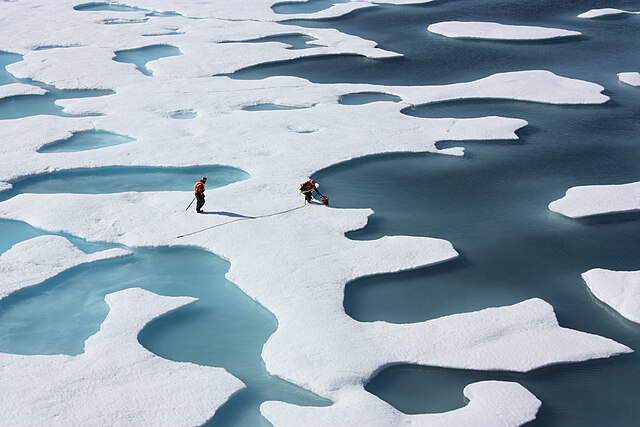
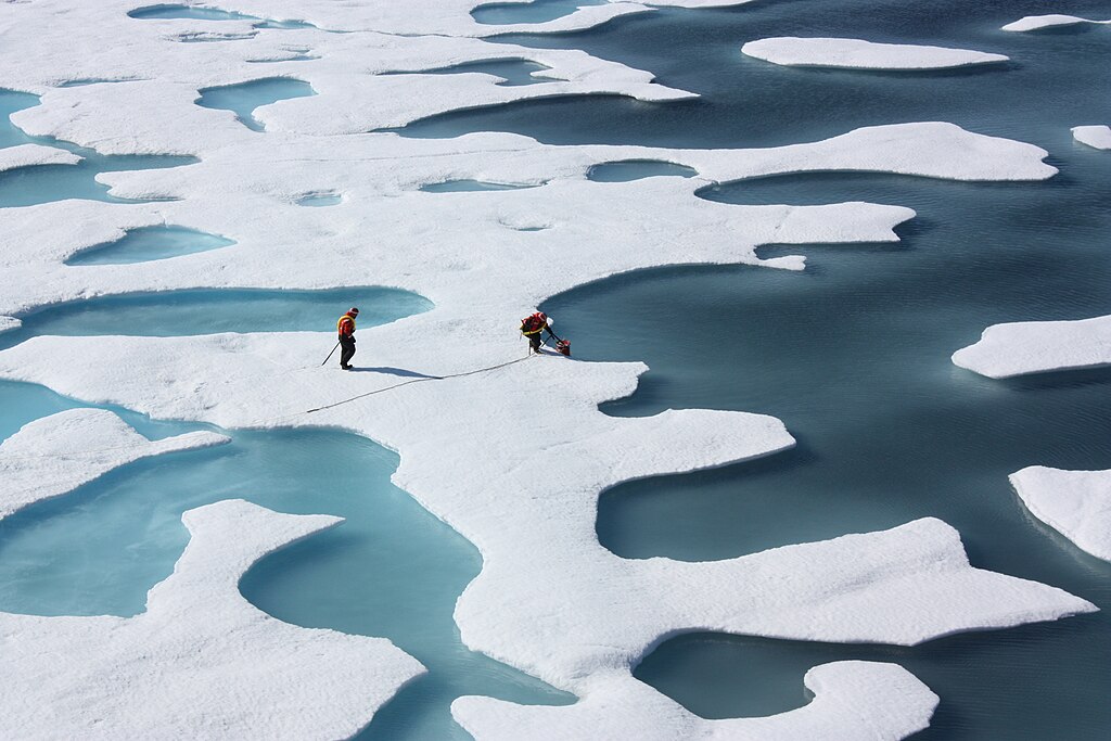
NASA image acquired July 12, 2011 If you have never been north of the Arctic Circle, it is easy to imagine that the “ice cap” at the top of the world is a uniform sheet of white. The reality, particularly during the spring and summer melt, is a mottled landscape of white, teal, slate gray, green, and navy. The sea ice atop the Arctic Ocean can—as shown in this photograph from July 12, 2011—look more like swiss cheese or a bright coastal wetland. As ice melts, the liquid water collects in depressions on the surface and deepens them, forming melt ponds. These fresh water ponds are separated from the salty sea below and around it, until breaks in the ice merge the two. Researchers on the NASA-funded ICESCAPE mission—Impacts of Climate on Ecosystems and Chemistry of the Arctic Pacific Environment—have been examining melt ponds, the ice around them, and the waters below for three weeks, with three more to go. Carried by the U.S. Coast Guard Cutter Healy, a team of oceanographers, marine biologists, and glaciologists are investigating how changing conditions in the Arctic affect the ocean’s chemical and biological makeup. The science team collects water samples to examine water chemistry and to observe the colonies of plankton growing in the water and on the surfaces of the ice. Other instruments are used to assess how much and how far sunlight is penetrating into—and warming—the Arctic Ocean. Still others are measuring the current systems that move water from the depths to the surface, as well as horizontally across the Beaufort and Chukchi Seas. Incidentally, the crew members in the photo are not harvesting data; they are collecting supplies. A C-130 airplane flew by earlier in the day, dropping a parachuted canister of hardware for fixing instruments and other machinery on the icebreaker. NASA science writer Kathryn Hansen is blogging daily from the ICESCAPE cruise. Click here to learn some science, see what people are eating, and sample life on an Arctic icebreaker. You can also get a daily glimpse of the ice in the Arctic by clicking on the MODIS Rapid Response page. NASA photograph by Kathryn Hansen. Caption by Mike Carlowicz. Instrument: Photograph To view other images from the Earth Observatory go to: earthobservatory.nasa.gov/ NASA Goddard Space Flight Center enables NASA’s mission through four scientific endeavors: Earth Science, Heliophysics, Solar System Exploration, and Astrophysics. Goddard plays a leading role in NASA’s accomplishments by contributing compelling scientific knowledge to advance the Agency’s mission. Follow us on Twitter Like us on Facebook Find us on Instagram |
| 日期 | |
| 來源 |
|
| 作者 | NASA Goddard Space Flight Center from Greenbelt, MD, USA |
| 其他版本 | https://www.flickr.com/photos/gsfc/7348420132/ https://www.flickr.com/photos/nasa_ice/5932034684/ |
授權條款
- 您可以自由:
- 分享 – 複製、發佈和傳播本作品
- 重新修改 – 創作演繹作品
- 惟需遵照下列條件:
- 姓名標示 – 您必須指名出正確的製作者,和提供授權條款的連結,以及表示是否有對內容上做出變更。您可以用任何合理的方式來行動,但不得以任何方式表明授權條款是對您許可或是由您所使用。
| This image, originally posted to Flickr, was reviewed on July 19, 2011 by the administrator or reviewer File Upload Bot (Magnus Manske), who confirmed that it was available on Flickr under the stated license on that date. |
| 本作品由NASA創作,屬於公有領域。根據NASA的版權政策:“NASA的創作除非另有聲明否則不受版權保護。”(參見:Template:PD-USGov/zh,NASA版權政策或JPL圖像使用政策) | ||
 |
警告:
|
檔案歷史
點選日期/時間以檢視該時間的檔案版本。
| 日期/時間 | 縮圖 | 尺寸 | 用戶 | 備註 | |
|---|---|---|---|---|---|
| 目前 | 2015年5月28日 (四) 13:33 | | 4,272 × 2,848(3.76 MB) | Prokaryotes | Higher resolution |
| 2011年7月19日 (二) 03:19 |  | 1,024 × 683(293 KB) | File Upload Bot (Magnus Manske) | {{Information |Description=NASA image acquired July 12, 2011 If you have never been north of the Arctic Circle, it is easy to imagine that the “ice cap” at the top of the world is a uniform sheet of white. The reality, particularly during the spring |
檔案用途
下列頁面有用到此檔案:
全域檔案使用狀況
以下其他 wiki 使用了這個檔案:
- ar.wikipedia.org 的使用狀況
- en.wikipedia.org 的使用狀況
- en.wiktionary.org 的使用狀況
- fa.wikipedia.org 的使用狀況
- fr.wikipedia.org 的使用狀況
- it.wikipedia.org 的使用狀況
- mk.wikipedia.org 的使用狀況
- no.wikipedia.org 的使用狀況
- ru.wikipedia.org 的使用狀況
- uk.wikipedia.org 的使用狀況
- vi.wikipedia.org 的使用狀況