
File:1850 Mitchell - Mitchell Map of Turkey in Asia - Geographicus - TurkeyAsia-m-50.jpg

本预览的尺寸:732 × 600像素。 其他分辨率:293 × 240像素 | 586 × 480像素 | 937 × 768像素 | 1,250 × 1,024像素 | 2,499 × 2,048像素 | 4,000 × 3,278像素。
原始文件 (4,000 × 3,278像素,文件大小:3.18 MB,MIME类型:image/jpeg)
| 塞繆爾·奧古斯都·米切爾:Turkey in Asia.
( |
||||||
|---|---|---|---|---|---|---|
| 艺术家 | ||||||
| 标题 |
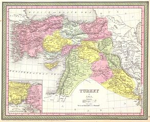
Turkey in Asia. |
|||||
| 描述 |
English: This beautiful hand colored map is a lithographic engraving of Turkey in Asia, dating to 1850. Beautiful map depicts most of modern day nations of Turkey, Iran, Iraq, Israel, Palestine, Jordan, Syria, Lebanon and Kuwait. There is a beautiful inset of the Environs of Constantinople or Istanbul. Produced by the legendary American map publisher S. A. Mitchell Sr. in conjunction with the Cowperthwait firm of Philadelphia, PA. Dated and copyrighted “1850 by Thomas Cowperthwait & Co in the Clerk’s Office of the District court of the Eastern District of Pennsylvania.”. |
|||||
| 日期 | 1850年 | |||||
| 尺寸 | 高度:12.5英寸(31.7厘米);寬度:15英寸(38.1厘米) | |||||
| 登录号 |
Geographicus link: TurkeyAsia-m-50 |
|||||
| 来源/摄影师 |
|
|||||
| 授权 (二次使用本文件) |
|
|||||
| 其他版本 | ||||||
.jpg)
文件历史
点击某个日期/时间查看对应时刻的文件。
| 日期/时间 | 缩略图 | 大小 | 用户 | 备注 | |
|---|---|---|---|---|---|
| 当前 | 2011年3月16日 (三) 07:46 | | 4,000 × 3,278(3.18 MB) | BotMultichill | {{subst:User:Multichill/Geographicus |link=http://www.geographicus.com/P/AntiqueMap/TurkeyAsia-m-50 |product_name=1850 Mitchell - Mitchell Map of Turkey in Asia |map_title=Turkey in Asia. |description=This beautiful hand colored map is a lithographic en |
文件用途
以下页面使用本文件:
全域文件用途
以下其他wiki使用此文件:
- ar.wikipedia.org上的用途
- pt.wikipedia.org上的用途