
File:2003 Bushfires aftermath, Big River near Anglers Rest.jpg

本预览的尺寸:800 × 541像素。 其他分辨率:320 × 217像素 | 640 × 433像素 | 872 × 590像素。
原始文件 (872 × 590像素,文件大小:411 KB,MIME类型:image/jpeg)
摘要
| 描述 |
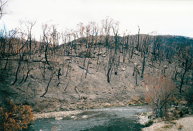
English: Aftermath of the 2003 Eastern Victorian alpine bushfires showing the Big River and hillsides near the Omeo Highway (probably from the Bundara River picnic ground), north of Anglers Rest, Victoria, Australia. |
|||
| 日期 | cApril 2003 | |||
| 来源 | 自己的作品 - scanned to digital, originally taken on a Ricoh compact film camera. | |||
| 作者 | jjron | |||
| 授权 (二次使用本文件) |
|
| 相机位置 | | 在以下服务上查看本图像和附近其他图像: OpenStreetMap |
|---|
许可协议
我,本作品著作权人,特此采用以下许可协议发表本作品:

|
已授权您依据自由软件基金会发行的无固定段落及封面封底文字(Invariant Sections, Front-Cover Texts, and Back-Cover Texts)的GNU自由文件许可协议1.2版的条款,复制、传播和/或修改本文件。该协议的副本请见“GNU Free Documentation License”。 | 仅1.2版 |
文件历史
点击某个日期/时间查看对应时刻的文件。
| 日期/时间 | 缩略图 | 大小 | 用户 | 备注 | |
|---|---|---|---|---|---|
| 当前 | 2010年12月28日 (二) 03:55 | | 872 × 590(411 KB) | Jjron | {{Information |Description={{en|1=Aftermath of the 2003 Eastern Victorian alpine bushfires showing the Big River and hillsides near the Omeo Highway (probably from the Bundara River picn |
文件用途
没有页面链接到本图像。
全域文件用途
以下其他wiki使用此文件:
- en.wikipedia.org上的用途
- es.wikipedia.org上的用途
- fa.wikipedia.org上的用途
- fr.wikipedia.org上的用途
- nl.wikipedia.org上的用途
- uk.wikipedia.org上的用途