
File:Antarctica (4), Adelaide Island, Stonehouse Bay.JPG

本预览的尺寸:800 × 531像素。 其他分辨率:320 × 213像素 | 640 × 425像素 | 1,024 × 680像素 | 1,280 × 850像素 | 1,716 × 1,140像素。
原始文件 (1,716 × 1,140像素,文件大小:449 KB,MIME类型:image/jpeg)
,_Adelaide_Island,_Stonehouse_Bay.JPG?uselang=zh)
,_Adelaide_Island,_Stonehouse_Bay.JPG?uselang=zh)
,_Adelaide_Island,_Stonehouse_Bay.JPG?action=history&uselang=zh)
,_Adelaide_Island,_Stonehouse_Bay.JPG)
摘要
| 描述 |
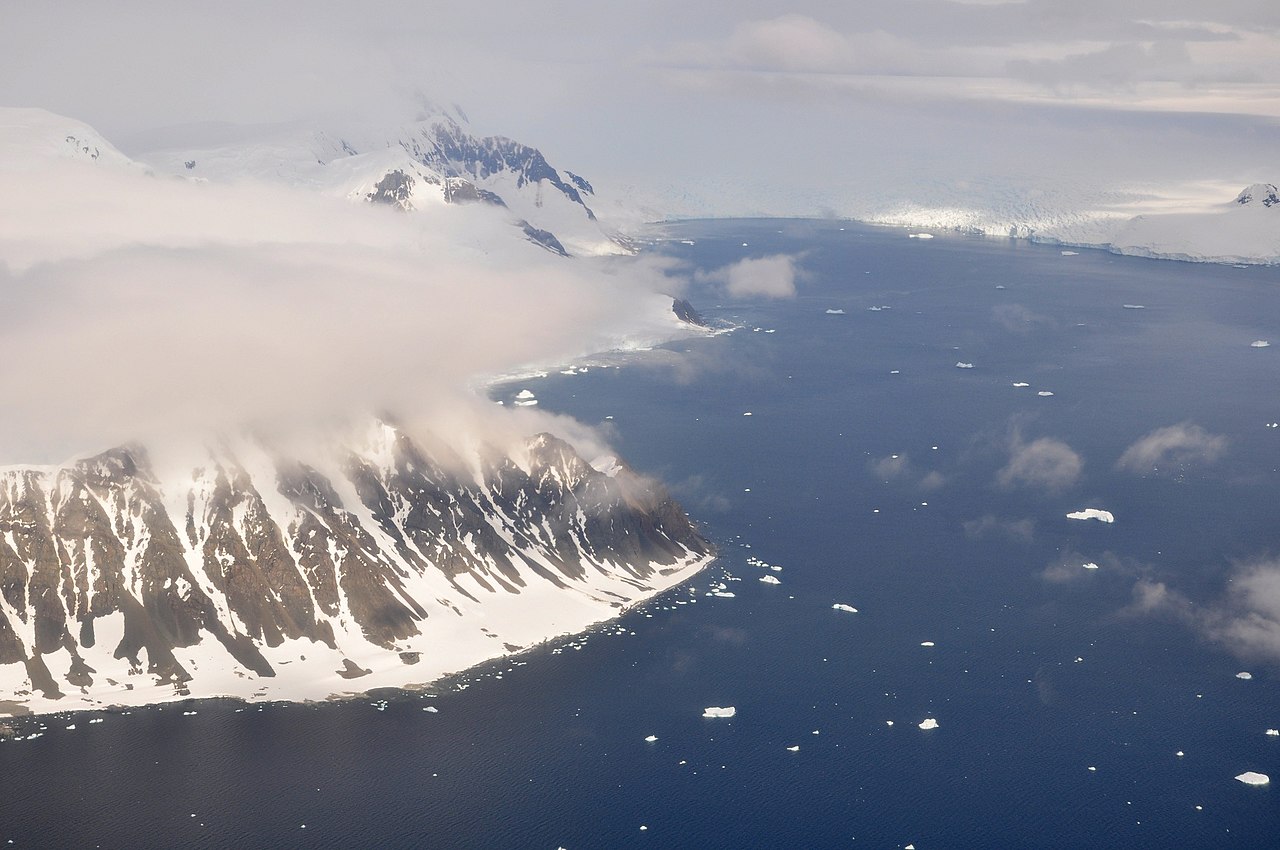
English: This picture is from the SW Antarctic Peninsula region.
It's an aerial view, looking West, from a position over Laubeuf Fjord to a part of Adelaide Island's east coast. In the foreground on the left is Sighing Peak, which forms the NE extremity of Adelaide Island's Wright Peninsula. The mountains behind it are the Stokes Peaks. The channel in front of Sighing Peak is called Cole Channel (and is actually a part of Laubeuf Fjord). The large body of water on the right is Stonehouse Bay. In the upper right hand corner of the picture, at the western end of Stonehouse Bay, is the huge and heavily crevassed Shambles Glacier; Adelaide Island's largest glacier. To the right of the glacier, at the extreme edge of the picture, is Dewar Nunatak. |
| 日期 | |
| 来源 | 自己的作品 |
| 作者 | Vincent van Zeijst |
•
| 相机位置 | | 在以下服务上查看本图像和附近其他图像: OpenStreetMap |
|---|
,_Adelaide_Island,_Stonehouse_Bay.JPG¶ms=-67.398517_N_-067.872161_E_globe:Earth_type:camera_heading:270.00&language=zh)
许可协议
我,本作品著作权人,特此采用以下许可协议发表本作品:
本文件采用知识共享署名-相同方式共享 3.0 未本地化版本许可协议授权。
- 您可以自由地:
- 共享 – 复制、发行并传播本作品
- 修改 – 改编作品
- 惟须遵守下列条件:
- 署名 – 您必须对作品进行署名,提供授权条款的链接,并说明是否对原始内容进行了更改。您可以用任何合理的方式来署名,但不得以任何方式表明许可人认可您或您的使用。
- 相同方式共享 – 如果您再混合、转换或者基于本作品进行创作,您必须以与原先许可协议相同或相兼容的许可协议分发您贡献的作品。
文件历史
点击某个日期/时间查看对应时刻的文件。
| 日期/时间 | 缩略图 | 大小 | 用户 | 备注 | |
|---|---|---|---|---|---|
| 当前 | 2011年3月10日 (四) 22:29 | | 1,716 × 1,140(449 KB) | Loranchet | {{Information |Description ={{en|1=This picture is from the SW Antarctic Peninsula region. It's an aerial view, looking West, from a position over Laubeuf Fjord to a part of Adelaide Island's east coast. In the foreground on the left is Sighing Peak, w |
文件用途
全域文件用途
以下其他wiki使用此文件:
- arz.wikipedia.org上的用途
- azb.wikipedia.org上的用途
- ceb.wikipedia.org上的用途
- de.wikipedia.org上的用途
- en.wikipedia.org上的用途
- es.wikipedia.org上的用途
- id.wikipedia.org上的用途
- it.wikipedia.org上的用途
- lld.wikipedia.org上的用途
- mk.wikipedia.org上的用途
- nn.wikipedia.org上的用途
- pl.wikipedia.org上的用途
- sv.wikipedia.org上的用途
- www.wikidata.org上的用途
,_Adelaide_Island,_Stonehouse_Bay.JPG)