
File:Dasht-e Kavir.jpg
原始文件 (5,822 × 5,820像素,文件大小:3.5 MB,MIME类型:image/jpeg)
摘要
| 描述 |
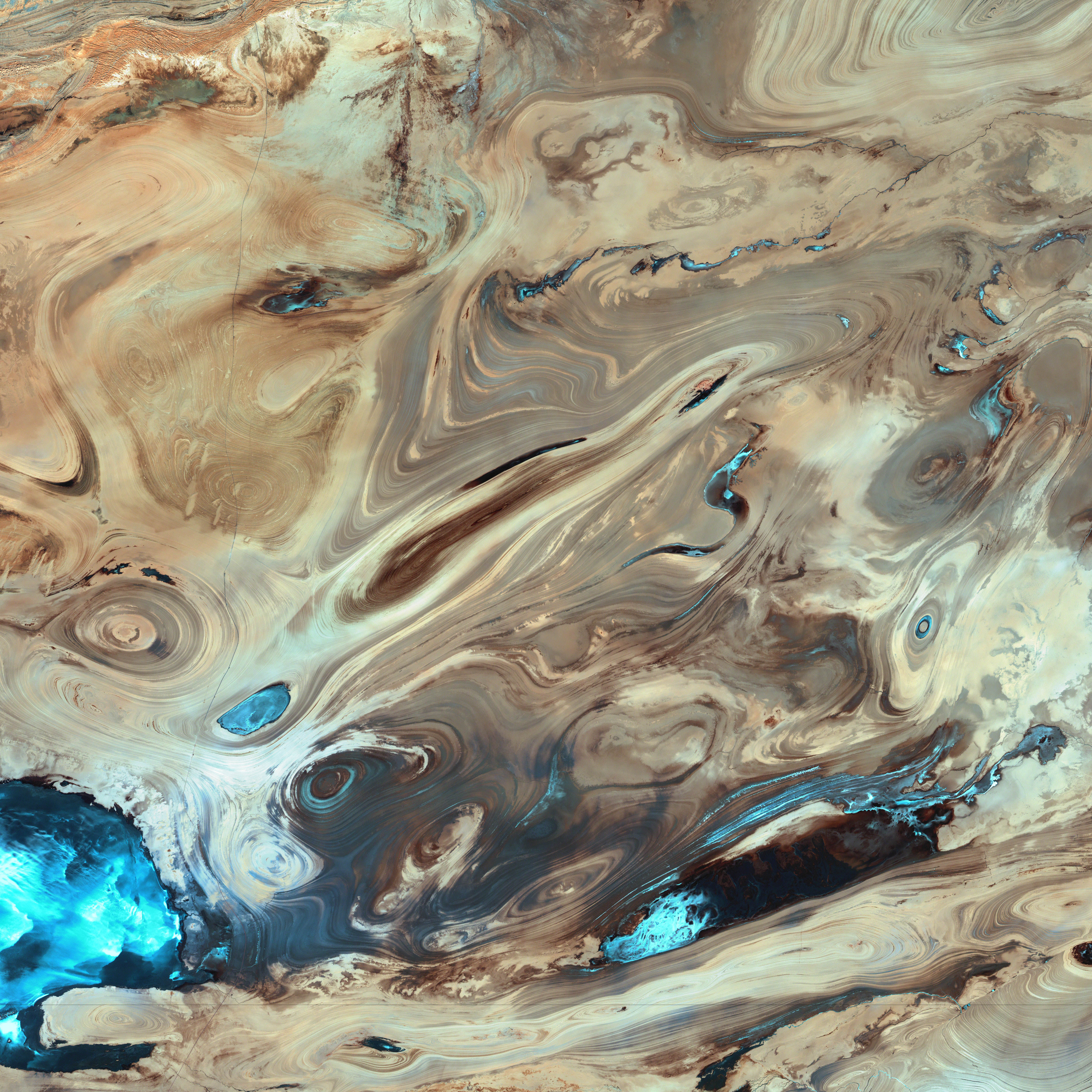
English: A satellite picture of the Dasht-e Kavir desert in Iran.
The patterns you see are formed by different geological layers that have been eroded over thousands of years by wind and sometimes (but not often) rain. The patterns are formed from either horizontal geological layers cut through by topographic changes, or geological formations (folds, domes, etc) in relatively flat terrain. Most of the colours are due to chemical differences in the rocks, whilst the intense blue colours could be due to a range of materials, possibly salt deposits, possibly vegetation, depending on which area of the EM spectrum is represented by blue. I suspect (but don't know, the satellite bands to displayed colours are not mentioned) that the blue colours are salt deposits, but they could equally be other materials too. To be certain, knowledge of the bands to display colours is essential. The black line running horizontally across the image is a sensor drop-out and the data for that line or lines has been irrevocably lost. The linear (but not straight) line running vertically down the middle left is a road. USGS/NASA description: The Dasht-e Kevir, or Great Salt Desert, is the largest desert in Iran. It is primarily uninhabited wasteland, composed of mud and salt marshes covered with crusts of salt that protect the meager moisture from completely evaporating. This image was acquired by Landsat 7’s Enhanced Thematic Mapper plus (ETM+) sensor on October 24, 2000. This is a false-color composite image made using infrared, green, and red wavelengths. The image has also been sharpened using the sensor’s panchromatic band.فارسی: تصویر ماهوارهای از دشت کویر ایران. اکثر رنگهای موجود در نگاره و تفاوتهای شیدهای مختلف، به دلایل اختلافهای ترکیبات شیمیایی مواد تشکیل دهنده صخرهها و تپهها است که در کنار یکدیگر جلوهگر شدهاند. رنگهای تند آبی احتمالاً ناشی از رسوب نمکهای باقی مانده از رستنیها و گیاهان کویری است. البته این استنتاج بستگی مستقیم به طیف الکترومغناطیسی دارد که با رنگ آبی نمایش داده شدهاست. |
| 日期 | |
| 来源 | NASA Earth Observatory. |
| 作者 | USGS EROS Data Center Satellite Systems Branch. |
| 物体位置 | | 在以下服务上查看本图像和附近其他图像: OpenStreetMap |
|---|
(centre of image)
许可协议
| 本文件完全由NASA创作,在美国属于公有领域。根据NASA的版权方针,NASA的材料除非另有声明否则不受版权保护。(参见Template:PD-USGov/zh、NASA版权方针页面或JPL图片使用方针。) | ||
 |
警告:
|
|
|
|
| 註解 | 該圖片含有註解:在維基媒體共享資源上查看註解 |
文件历史
点击某个日期/时间查看对应时刻的文件。
| 日期/时间 | 缩略图 | 大小 | 用户 | 备注 | |
|---|---|---|---|---|---|
| 当前 | 2006年1月18日 (三) 20:39 | | 5,822 × 5,820(3.5 MB) | David.Monniaux | ran it through jpegtran to output optimized, non-progressive jpeg |
| 2006年1月18日 (三) 20:09 |  | 5,822 × 5,820(3.66 MB) | Palladinus | Dasht-e Kavir desert in Iran |
文件用途
没有页面链接到本图像。
全域文件用途
以下其他wiki使用此文件:
- als.wikipedia.org上的用途
- ar.wikipedia.org上的用途
- azb.wikipedia.org上的用途
- az.wikipedia.org上的用途
- be.wikipedia.org上的用途
- bg.wikipedia.org上的用途
- bs.wikipedia.org上的用途
- ca.wikipedia.org上的用途
- cs.wikipedia.org上的用途
- de.wikipedia.org上的用途
- en.wikipedia.org上的用途
- es.wikipedia.org上的用途
- es.wikibooks.org上的用途
- es.wikisource.org上的用途
- et.wikipedia.org上的用途
- eu.wikipedia.org上的用途
- fa.wikipedia.org上的用途
- دشت کویر
- ویکیپدیا:انتخاب نگاره هفته/سال ۲۰۱۱/هفته ۱
- ویکیپدیا:انتخاب نگاره هفته/سال ۲۰۱۱/هفته ۱/کویر مرکزی ایران
- ویکیپدیا:نگارههای برگزیده/پدیدههای طبیعی
- ویکیپدیا:نگارههای برگزیده/علمی/زمینشناسی
- ویکیپدیا:گزیدن نگاره برگزیده/فوریه-۲۰۱۲
- ویکیپدیا:نگاره روز/ژوئن ۲۰۱۲
- ویکیپدیا:گزیدن نگاره برگزیده/Dasht-e Kavir.jpg
- الگو:نر/2012-06-21
- الگو:نر محافظت شده/2012-06-21
- بحث کاربر:Alborzagros/بایگانی ۵
- درگاه:علوم زمین/نگاره برگزیده/۲
- درگاه:علوم زمین/نگاره برگزیده
- تصویربرداری ماهوارهای
- fr.wikipedia.org上的用途
- gd.wikipedia.org上的用途
- gl.wikipedia.org上的用途
- hr.wikipedia.org上的用途
- id.wikipedia.org上的用途
查看本文件的更多全域用途。