
File:Egypt Sudan claims.svg

此SVG文件的PNG预览的大小:400 × 600像素。 其他分辨率:160 × 240像素 | 320 × 480像素 | 512 × 768像素 | 682 × 1,024像素 | 1,365 × 2,048像素。
原始文件 (SVG文件,尺寸为512 × 768像素,文件大小:461 KB)
摘要
| 描述 |
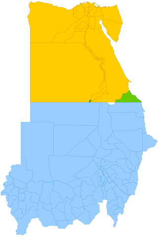
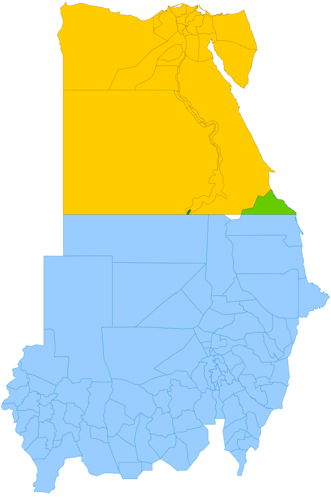
English: Simplified map showing Egypt's claim (yellow and green), Sudan's claim (blue and green), the Hala'ib Triangle (light green), Wadi Halfa Salient (dark green) and Bir Tawil (white). |
| 日期 | (UTC) |
| 来源 |
本檔案衍生自: |
| 作者 | |
| SVG开发 |

许可协议
本文件采用知识共享署名-相同方式共享 3.0 未本地化版本许可协议授权。
- 您可以自由地:
- 共享 – 复制、发行并传播本作品
- 修改 – 改编作品
- 惟须遵守下列条件:
- 署名 – 您必须对作品进行署名,提供授权条款的链接,并说明是否对原始内容进行了更改。您可以用任何合理的方式来署名,但不得以任何方式表明许可人认可您或您的使用。
- 相同方式共享 – 如果您再混合、转换或者基于本作品进行创作,您必须以与原先许可协议相同或相兼容的许可协议分发您贡献的作品。
原始上传日志
This image is a derivative work of the following images:
- File:Political_Regions_of_Sudan,_July_2010.svg licensed with Cc-zero
- File:Egypt_location_map.svg licensed with Cc-by-sa-3.0, GFDL
- 2011-04-17T16:03:10Z NordNordWest 1055x973 (359140 Bytes) upd
- 2010-03-07T17:03:18Z NordNordWest 1055x973 (566369 Bytes) resize
- 2009-09-03T10:48:31Z NordNordWest 1055x956 (565065 Bytes)
- 2009-05-23T19:10:12Z NordNordWest 1056x959 (570357 Bytes) corr
- 2008-08-10T11:12:09Z NordNordWest 1056x957 (503154 Bytes) {{Information |Description= {{de|Positionskarte von [[:de:Ägypten|Ägypten]]}} Quadratische Plattkarte, N-S-Streckung 110 %. Geographische Begrenzung der Karte: * N: 32.1° N * S: 21.3° N * W: 24.2° O * O: 37.3° O {{en|Lo
Uploaded with derivativeFX
文件历史
点击某个日期/时间查看对应时刻的文件。
| 日期/时间 | 缩略图 | 大小 | 用户 | 备注 | |
|---|---|---|---|---|---|
| 当前 | 2021年10月13日 (三) 11:15 | | 512 × 768(461 KB) | Cmglee | Shade Wadi Halfa Salient as per http://commons.wikimedia.org/wiki/File_talk:Egypt_Sudan_claims.svg#Wadi_Halfa_Salient |
| 2019年2月16日 (六) 12:58 |  | 512 × 768(461 KB) | AntiCompositeNumber | Avoid messing with file structure so much when <!-- --> will work | |
| 2019年2月16日 (六) 12:51 |  | 512 × 768(465 KB) | AntiCompositeNumber | Remove striping that makes image harder to see per request at e n:Wikipedia:Graphics_Lab/Map_workshop | |
| 2018年6月21日 (四) 17:47 |  | 512 × 768(461 KB) | Cmglee | Add white background as per File_talk:Egypt_Sudan_claims.svg#Bir_Tawil_area | |
| 2015年11月8日 (日) 17:44 |  | 512 × 768(460 KB) | McGeddon | Remove unnecessary captions, image is colour-coded. | |
| 2013年1月11日 (五) 21:28 |  | 512 × 768(461 KB) | Cmglee | Update colours and label alignment. | |
| 2013年1月11日 (五) 21:19 |  | 512 × 768(461 KB) | Cmglee | == {{int:filedesc}} == {{Information |Description={{en|Map showing political regions of Sudan as of July 2006.}} {{legend|#8cc63f|Darfur}} {{legend|#fb6282|Nuba Mountains and Blue Nile}} {{legend|#f7931d|North Sudan}} {{legend|#800080|Eastern Front, ar... |
文件用途
以下4个页面使用本文件:
全域文件用途
以下其他wiki使用此文件:
- ar.wikipedia.org上的用途
- arz.wikipedia.org上的用途
- az.wikipedia.org上的用途
- be.wikipedia.org上的用途
- cs.wikipedia.org上的用途
- da.wikipedia.org上的用途
- de.wikipedia.org上的用途
- de.wikivoyage.org上的用途
- el.wikipedia.org上的用途
- en.wikipedia.org上的用途
- en.wikivoyage.org上的用途
- eo.wikipedia.org上的用途
- es.wikipedia.org上的用途
- fi.wikipedia.org上的用途
- fr.wikipedia.org上的用途
- gl.wikipedia.org上的用途
- id.wikipedia.org上的用途
- it.wikipedia.org上的用途
- ja.wikipedia.org上的用途
- ja.wikivoyage.org上的用途
- ko.wikipedia.org上的用途
- ms.wikipedia.org上的用途
- nl.wikipedia.org上的用途
- no.wikipedia.org上的用途
- pt.wikipedia.org上的用途
- ro.wikipedia.org上的用途
- so.wikipedia.org上的用途
- sr.wikipedia.org上的用途
- uk.wikipedia.org上的用途
- vi.wikipedia.org上的用途
- www.wikidata.org上的用途