
File:Eyjafjallajökull volcanic ash composite.png

本预览的尺寸:600 × 600像素。 其他分辨率:240 × 240像素 | 480 × 480像素 | 726 × 726像素。
原始文件 (726 × 726像素,文件大小:95 KB,MIME类型:image/png)
| 描述 |
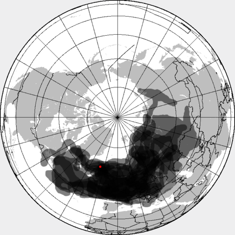
This is a composite map showing the position of the Icelandinc volcanic ash cloud that closed European air space in different days. Based on maps found at http://www.metoffice.gov.uk/aviation/vaac/vaacuk_vag.html Days included:
|
| 日期 | (UTC) |
| 来源 | |
| 作者 |
|
| 这是一张修改过的图片,这意味着它已在原版本的基础上通过软件进行了编辑,改动内容:made all day layers visible。其原始版本为:Eyjafjallajökull volcanic ash multilayer.xcf。修改者: Cogiati。
|
我,本作品著作权人,特此采用以下许可协议发表本作品:
本文件采用知识共享署名-相同方式共享 3.0 未本地化版本许可协议授权。
- 您可以自由地:
- 共享 – 复制、发行并传播本作品
- 修改 – 改编作品
- 惟须遵守下列条件:
- 署名 – 您必须对作品进行署名,提供授权条款的链接,并说明是否对原始内容进行了更改。您可以用任何合理的方式来署名,但不得以任何方式表明许可人认可您或您的使用。
- 相同方式共享 – 如果您再混合、转换或者基于本作品进行创作,您必须以与原先许可协议相同或相兼容的许可协议分发您贡献的作品。
原始上传日志
This image is a derivative work of the following images:
- File:Eyjafjallajökull_volcanic_ash_multilayer.xcf licensed with Cc-by-sa-3.0
- 2010-04-25T01:29:03Z Cogiati 0x0 (853897 Bytes) added 22 april
- 2010-04-25T01:17:42Z Cogiati 0x0 (845598 Bytes) added 21 april
- 2010-04-25T00:01:51Z Cogiati 0x0 (832938 Bytes) added 19 april
- 2010-04-24T23:20:51Z Cogiati 0x0 (818621 Bytes) added 24 april
- 2010-04-23T21:13:03Z Cogiati 0x0 (814673 Bytes) added 15 april
- 2010-04-23T20:54:25Z Cogiati 0x0 (808456 Bytes) {{Information |Description=This map shows the Icelandic volcanic ash cloud that closed European air space. Every day is shown in a different layer. It's an XCf file editable with GIMP. Based on maps found at http://www.metoff
Uploaded with derivativeFX
文件历史
点击某个日期/时间查看对应时刻的文件。
| 日期/时间 | 缩略图 | 大小 | 用户 | 备注 | |
|---|---|---|---|---|---|
| 当前 | 2010年4月27日 (二) 14:53 | | 726 × 726(95 KB) | Cogiati | added 17 april |
| 2010年4月26日 (一) 14:09 |  | 726 × 726(93 KB) | Cogiati | added 18 april | |
| 2010年4月26日 (一) 07:32 |  | 726 × 726(92 KB) | Cogiati | added 25 April | |
| 2010年4月25日 (日) 16:00 |  | 726 × 726(91 KB) | Cogiati | added 16 april | |
| 2010年4月25日 (日) 01:56 |  | 726 × 726(90 KB) | Cogiati | added 20 april | |
| 2010年4月25日 (日) 01:32 |  | 726 × 726(88 KB) | Cogiati | {{Information |Description=This is a composite map showing the position of the Icelandinc volcanic ash cloud that closed European air space in different days. Based on maps found at http://www.metoffice.gov.uk/aviation/vaac/vaacuk_vag.html Days included: |
文件用途
以下页面使用本文件:
全域文件用途
以下其他wiki使用此文件:
- ca.wikipedia.org上的用途
- da.wikipedia.org上的用途
- de.wikipedia.org上的用途
- en.wikipedia.org上的用途
- es.wikipedia.org上的用途
- eu.wikipedia.org上的用途
- fi.wikipedia.org上的用途
- hu.wikipedia.org上的用途
- it.wikipedia.org上的用途
- ja.wikipedia.org上的用途
- pnb.wikipedia.org上的用途
- pt.wikipedia.org上的用途
- ru.wikipedia.org上的用途
- th.wikipedia.org上的用途
- ur.wikipedia.org上的用途
- vi.wikipedia.org上的用途