
File:Falaise Pocket German Counterattack.png
此为最大尺寸。
Falaise_Pocket_German_Counterattack.png (800 × 577像素,文件大小:222 KB,MIME类型:image/png)

|
此battle map图片可使用矢量图形重新创建为SVG文件。这具有很多好处;更多信息请参见共享资源:待清理媒体。如果存在此图片的SVG格式,请将其上传,然后将此模板替换为
{{vector version available|新图片名称}}。
建议您将SVG命名为“Falaise Pocket German Counterattack.svg”,这样在使用Vector version available(或Vva)模板时就不需要填写新图片名称参数。 |
摘要
| 描述 |
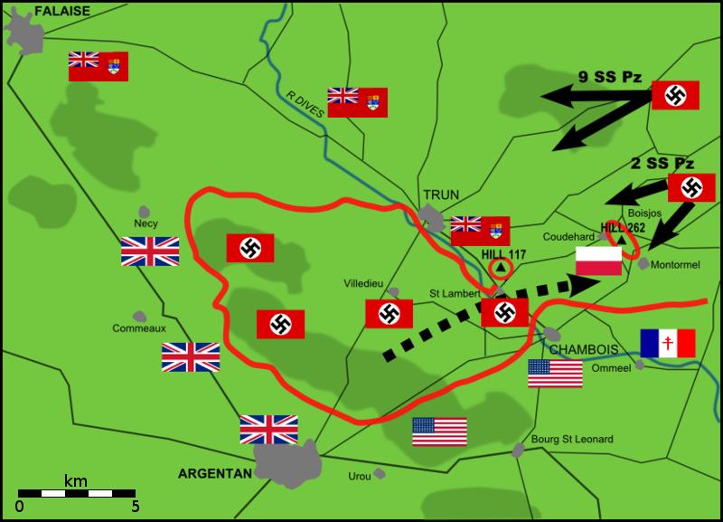
English: Map of German counterattacks, 20 August 1944, on Polish position on Hill 262, north-east of Chambois, Falaise Pocket, Normandy |
| 日期 | |
| 来源 | Own work by uploader from Mémorial de Coudehard - Montormel, the memorial website for the battle. |
| 作者 | EyeSerene |
许可协议
| 我,本作品著作权人,释出本作品至公有领域。这适用于全世界。 在一些国家这可能不合法;如果是这样的话,那么: 我无条件地授予任何人以任何目的使用本作品的权利,除非这些条件是法律规定所必需的。 |
文件历史
点击某个日期/时间查看对应时刻的文件。
| 日期/时间 | 缩略图 | 大小 | 用户 | 备注 | |
|---|---|---|---|---|---|
| 当前 | 2012年4月20日 (五) 00:27 | | 800 × 577(222 KB) | Kbh3rd | Added scale bar - snapshot Google maps of same area, overlay in image editor, rotate and scale to match features, and use Google's scale bar as a guide. Approximate but close enough |
| 2010年1月17日 (日) 17:57 |  | 800 × 577(185 KB) | Mahahahaneapneap | Compressed | |
| 2009年4月27日 (一) 10:11 |  | 800 × 577(200 KB) | EyeSerene | Replace Maple Leaf flag with correct-for-time Red Ensign | |
| 2009年3月30日 (一) 13:05 |  | 800 × 577(216 KB) | Chrzanko | corrected the location of Saint Lambert | |
| 2008年10月10日 (五) 17:10 |  | 828 × 597(171 KB) | EyeSerene | Replaced Canadian military flags with national flag | |
| 2008年9月4日 (四) 20:11 |  | 828 × 597(174 KB) | EyeSerene | {{Information |Description={{en|1=Map of German counterattacks, 20 August 2008, on Polish position on Hill 262, north-east of Chambois, Falaise Pocket, Normandy}} |Source=Own work by uploader |Author=EyeSerene |Date=Sept 2008 |Permissio |
文件用途
以下页面使用本文件:
全域文件用途
以下其他wiki使用此文件:
- da.wikipedia.org上的用途
- de.wikipedia.org上的用途
- en.wikipedia.org上的用途
- ko.wikipedia.org上的用途
- pl.wikipedia.org上的用途
- pt.wikipedia.org上的用途
- ru.wikipedia.org上的用途