
File:Finland physical map.svg

此SVG文件的PNG预览的大小:303 × 598像素。 其他分辨率:121 × 240像素 | 243 × 480像素 | 389 × 768像素 | 518 × 1,024像素 | 1,037 × 2,048像素 | 427 × 843像素。
原始文件 (SVG文件,尺寸为427 × 843像素,文件大小:3.97 MB)
摘要
| 描述 |
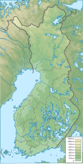
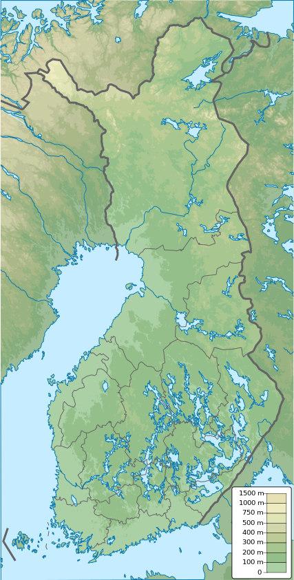
English: Finland physical map, parameters equal to File:Finland location map.svg |
| 日期 | |
| 来源 | 自己的作品 |
| 作者 | Urutseg |
许可协议
| 我,本作品著作权人,释出本作品至公有领域。这适用于全世界。 在一些国家这可能不合法;如果是这样的话,那么: 我无条件地授予任何人以任何目的使用本作品的权利,除非这些条件是法律规定所必需的。 |
文件历史
点击某个日期/时间查看对应时刻的文件。
| 日期/时间 | 缩略图 | 大小 | 用户 | 备注 | |
|---|---|---|---|---|---|
| 当前 | 2021年1月26日 (二) 12:09 | | 427 × 843(3.97 MB) | Fenn-O-maniC | Updated regional borders as per https://asiointi.maanmittauslaitos.fi/karttapaikka/ |
| 2019年11月25日 (一) 23:39 |  | 427 × 843(3.99 MB) | Pavouk | update border North_Ostrobothnia (+Vaala), delete Eastern Uusimaa, change border (Aland inside Finland, not out) | |
| 2011年2月13日 (日) 13:54 |  | 427 × 843(3.99 MB) | Urutseg | {{Information |Description ={{en|1=Finland physical map, parameters equal to File:Finland location map.svg}} |Source ={{own}} |Author =Urutseg |Date =2011-02-13 |Permission = |other_versions = }} [[C |
文件用途
以下15个页面使用本文件:
全域文件用途
以下其他wiki使用此文件:
- am.wikipedia.org上的用途
- av.wikipedia.org上的用途
- az.wikipedia.org上的用途
- be.wikipedia.org上的用途
- bn.wikipedia.org上的用途
- bs.wikipedia.org上的用途
- ca.wikipedia.org上的用途
- ceb.wikipedia.org上的用途
- ce.wikipedia.org上的用途
- ckb.wikipedia.org上的用途
- da.wikipedia.org上的用途
查看本文件的更多全域用途。