
File:Frankish Foederatus.png
此为最大尺寸。
Frankish_Foederatus.png (570 × 471像素,文件大小:73 KB,MIME类型:image/png)
文件历史
点击某个日期/时间查看对应时刻的文件。
| 日期/时间 | 缩略图 | 大小 | 用户 | 备注 | |
|---|---|---|---|---|---|
| 当前 | 2009年4月11日 (六) 15:09 | | 570 × 471(73 KB) | HP1740-B~commonswiki | Vernieuwd |
| 2009年4月10日 (五) 12:09 |  | 570 × 471(71 KB) | HP1740-B~commonswiki | Kust | |
| 2009年3月31日 (二) 19:40 |  | 570 × 471(74 KB) | HP1740-B~commonswiki | Names | |
| 2009年3月31日 (二) 19:37 |  | 570 × 471(71 KB) | HP1740-B~commonswiki | geography | |
| 2009年3月31日 (二) 18:14 |  | 570 × 471(86 KB) | HP1740-B~commonswiki | idem | |
| 2009年3月31日 (二) 17:57 |  | 570 × 471(91 KB) | HP1740-B~commonswiki | Corrective spelling. | |
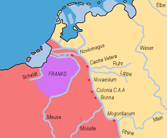
| 2009年3月31日 (二) 12:19 |  | 570 × 471(87 KB) | HP1740-B~commonswiki | {{Information |Description={{en|1=A map of the Frankish Empire, rivers, limes, the Barbarian lands surrounding it and the Frankish Foederatus superimposed on modern day North Western Europe. }} |Source=Own work by uploader |Author=[[User:HP1740-B|HP1740-B |
文件用途
以下页面使用本文件:
全域文件用途
以下其他wiki使用此文件:
- ar.wikipedia.org上的用途
- ca.wikipedia.org上的用途
- cs.wikipedia.org上的用途
- cy.wikipedia.org上的用途
- en.wikipedia.org上的用途
- es.wikipedia.org上的用途
- eu.wikipedia.org上的用途
- fr.wikipedia.org上的用途
- id.wikipedia.org上的用途
- it.wikipedia.org上的用途
- ko.wikipedia.org上的用途
- pt.wikipedia.org上的用途
- sl.wikipedia.org上的用途