
File:Iraq.A2003060.0750.500m.jpg

本预览的尺寸:461 × 599像素。 其他分辨率:184 × 240像素 | 369 × 480像素 | 591 × 768像素 | 788 × 1,024像素 | 2,000 × 2,600像素。
原始文件 (2,000 × 2,600像素,文件大小:1,012 KB,MIME类型:image/jpeg)
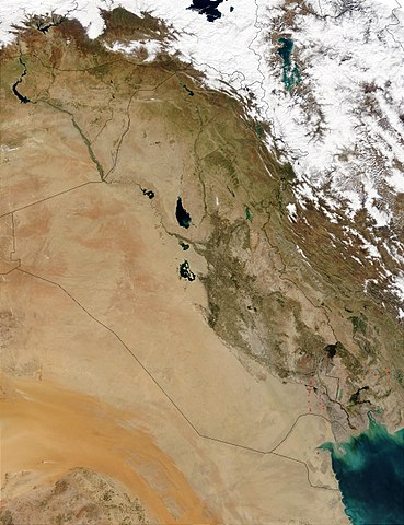
This Moderate Resolution Imaging Spectroradiometer (MODIS) image from March 1, 2003, shows numerous oil well flares (the burning off of combustible gases associated with oil) in southern Iraq (center). The way the active hot spots, marked in red, line up almost vertically suggests they are along a pipeline. Meanwhile, hot spots in southern Iran (right) are likely agricultural fires.
http://visibleearth.nasa.gov/view_rec.php?id=5166
| 本文件完全由NASA创作,在美国属于公有领域。根据NASA的版权方针,NASA的材料除非另有声明否则不受版权保护。(参见Template:PD-USGov/zh、NASA版权方针页面或JPL图片使用方针。) | ||
 |
警告:
|
文件历史
点击某个日期/时间查看对应时刻的文件。
| 日期/时间 | 缩略图 | 大小 | 用户 | 备注 | |
|---|---|---|---|---|---|
| 当前 | 2005年10月26日 (三) 15:05 | | 2,000 × 2,600(1,012 KB) | Brian0918 | This Moderate Resolution Imaging Spectroradiometer (MODIS) image from March 1, 2003, shows numerous oil well flares (the burning off of combustible gases associated with oil) in southern Iraq (center). The way the active hot spots, marked in red, line up |
文件用途
以下页面使用本文件:
全域文件用途
以下其他wiki使用此文件:
- ar.wikipedia.org上的用途
- ar.wikiquote.org上的用途
- da.wikipedia.org上的用途
- en.wikipedia.org上的用途
- fi.wikipedia.org上的用途
- gl.wikipedia.org上的用途
- hr.wikipedia.org上的用途
- hy.wikipedia.org上的用途
- ka.wikipedia.org上的用途
- km.wikipedia.org上的用途
- ko.wikipedia.org上的用途
- lt.wikipedia.org上的用途
- mn.wikipedia.org上的用途
- nn.wikipedia.org上的用途
- no.wikipedia.org上的用途
- nrm.wikipedia.org上的用途
- pl.wikipedia.org上的用途
- pt.wikipedia.org上的用途
- sh.wikipedia.org上的用途
- sl.wikipedia.org上的用途
- sr.wikipedia.org上的用途
- sv.wikipedia.org上的用途
- te.wikipedia.org上的用途
- tr.wikipedia.org上的用途
- uk.wikipedia.org上的用途