
File:Ireland (MODIS).jpg
本预览的尺寸:436 × 600像素。 其他分辨率:174 × 240像素 | 349 × 480像素 | 558 × 768像素 | 745 × 1,024像素 | 1,600 × 2,200像素。
原始文件 (1,600 × 2,200像素,文件大小:2.69 MB,MIME类型:image/jpeg)
摘要
| 描述 |
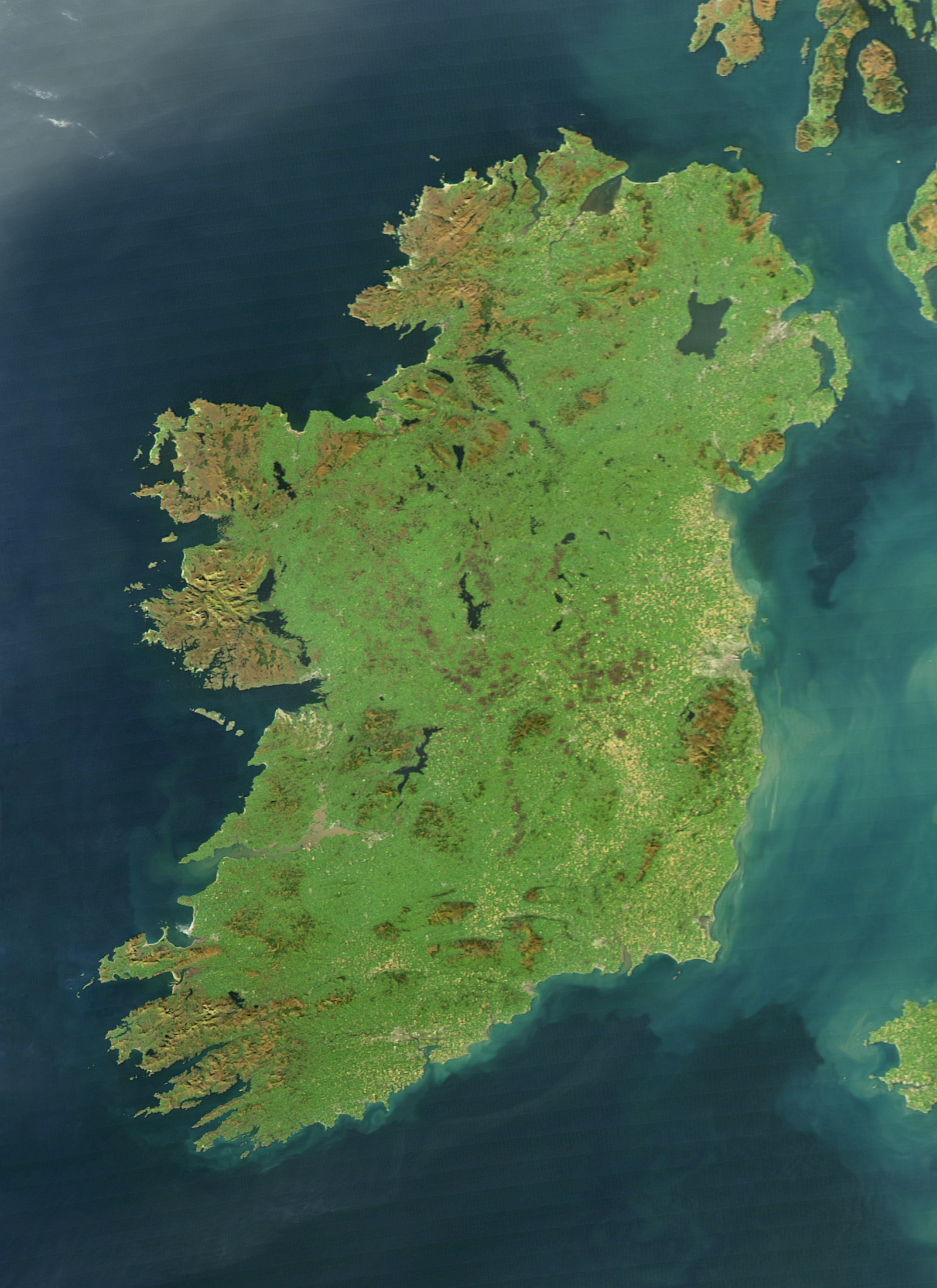
English: It is easy to see from this true-colour image why Ireland is called the Emerald Isle. Intense green vegetation, primarily grassland, covers most of the country except for the exposed rock on mountaintops. Ireland owes its greenness to moderate temperatures and moist air. The Atlantic Ocean, particularly the warm currents in the North Atlantic Drift, gives the country a more temperate climate than most others at the same latitude. |
| 日期 | |
| 来源 | NASA Earth Observatory |
| 作者 | Jeff Schmaltz |
| 其他版本 |
|
.jpg?uselang=zh)
.jpg?uselang=zh)
.jpg?action=history&uselang=zh)
.jpg)
The cloud-free view shown here is extremely rare. The Moderate Resolution Imaging Spectroradiometer (MODIS) on NASA’s Aqua satellite captured the image on October 11, 2010, a time of year when Irish weather alternates between rainstorms from the west and cool, dry weather brought by high pressure systems known as anticyclones.
许可协议
| 本文件完全由NASA创作,在美国属于公有领域。根据NASA的版权方针,NASA的材料除非另有声明否则不受版权保护。(参见Template:PD-USGov/zh、NASA版权方针页面或JPL图片使用方针。) | ||
 |
警告:
|
文件历史
点击某个日期/时间查看对应时刻的文件。
| 日期/时间 | 缩略图 | 大小 | 用户 | 备注 | |
|---|---|---|---|---|---|
| 当前 | 2017年8月4日 (五) 12:14 | | 1,600 × 2,200(2.69 MB) | Blight55 | quality degraded from original, taken from original |
| 2017年4月21日 (五) 10:04 |  | 1,600 × 2,200(1.16 MB) | Blight55 | No borders in space, removed clouds | |
| 2011年12月25日 (日) 20:18 |  | 1,600 × 2,200(532 KB) | Tóraí | Less sever colour adjustments from original. | |
| 2011年12月13日 (二) 13:41 |  | 1,512 × 1,928(800 KB) | Soerfm | Brightness, crop | |
| 2011年3月17日 (四) 10:22 |  | 1,600 × 2,200(409 KB) | Originalwana | {{Information |Description ={{en|1=It is easy to see from this true-colour image why Ireland is called the Emerald Isle. Intense green vegetation, primarily grassland, covers most of the country except for the exposed rock on mountaintops. Ireland |
文件用途
以下3个页面使用本文件:
全域文件用途
以下其他wiki使用此文件:
- af.wikipedia.org上的用途
- ar.wikipedia.org上的用途
- arz.wikipedia.org上的用途
- ast.wikipedia.org上的用途
- az.wikipedia.org上的用途
- be-tarask.wikipedia.org上的用途
- br.wikipedia.org上的用途
- ca.wikipedia.org上的用途
- ceb.wikipedia.org上的用途
- cy.wikipedia.org上的用途
- da.wikipedia.org上的用途
- de.wikipedia.org上的用途
- el.wikipedia.org上的用途
- en.wikipedia.org上的用途
- Ireland
- Geography of Ireland
- Gaelic Athletic Association
- Irish Rugby Football Union
- Swim Ireland
- Sport in Ireland
- United Ireland
- Rugby League Ireland
- Irish Real Tennis Association
- Irish Sailing Association
- Hurlingham Polo Association
- List of fractals by Hausdorff dimension
- Cricket Ireland
- Australian Rules Football League of Ireland
- Baseball in Ireland
- Irish Ice Hockey Association
- Baseball Ireland
- Fencing Ireland
- Olympic Federation of Ireland
- Ladies' Gaelic Football Association
- Softball in Ireland
- Pitch and Putt Union of Ireland
- Cycling Ireland
- Horse Sport Ireland
- Basketball Ireland
- Tennis Ireland
- Boxing Union of Ireland
- Parachute Association of Ireland
- Football Association of Ireland
- Hockey Ireland
查看本文件的更多全域用途。
.jpg)
.jpg)