
File:Kyiv, Ukraine ESA22370890 (cropped).jpeg

本预览的尺寸:600 × 600像素。 其他分辨率:240 × 240像素 | 480 × 480像素 | 768 × 768像素 | 1,024 × 1,024像素 | 2,048 × 2,048像素 | 3,258 × 3,258像素。
原始文件 (3,258 × 3,258像素,文件大小:2.81 MB,MIME类型:image/jpeg)
摘要
| 描述 |
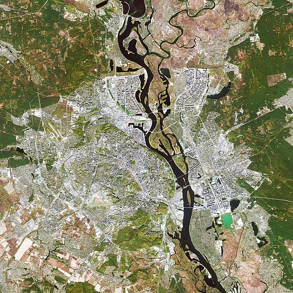
English: The Copernicus Sentinel-2 mission takes us over Kyiv – the capital and most populous city of Ukraine. Zoom in to see this image at its full 10 m resolution. Kyiv, also spelled Kiev, is visible just below the centre of the image, along the Dnieper River in north-central Ukraine. The city covers a total area of around 840 sq km and is home to approximately three million people. Originally just on the west bank, today the city of Kyiv spreads across both sides of the Dnieper River, which flows southwards through the city. The Dnieper is the fourth-longest river in Europe, after the Volga, Danube and Ural rivers. It rises on the southern slopes of the Valdai Hills of Russia and flows in a southerly direction through western Russia, Belarus and Ukraine to the Black Sea. Directly above the city of Kyiv is the Kyiv Reservoir – a large water reservoir which is 110 km in length and 12 km in width. The reservoir is mainly used for irrigation, hydroelectricity generation and industrial and public consumption. The neon green colours in the Kyiv Reservoir indicate a high quantity of algae. Algal blooms are dense layers of microscopic plants that occur on the surface of lakes, or other bodies of water, when there is an overabundance of nutrients on which algae depend. These high levels of nutrients are often caused by human pollution, such as wastewater or fertiliser runoff from agriculture. Owing to Ukraine’s climate and arable land, agriculture plays a large role in the country’s economy. Large, agricultural plots dominate this week’s image, with corn, wheat and barley being the country’s main crops. With over 40 million hectares of agricultural land covering 70% of the country, agriculture is Ukraine’s largest export industry. Copernicus Sentinel-2 is a two-satellite mission. Each satellite carries a high-resolution camera that images Earth’s surface in 13 spectral bands. The mission is mostly used to track changes in the way land is being used and to monitor the health of our vegetation. This image is also featured on the Earth from Space video programme. |
| 日期 | 2020年12月11日 (上传日期) |
| 来源 | Kyiv, Ukraine |
| 作者 | European Space Agency |
| 其他版本 |
|
| Activity | Observing the Earth |
| Mission | Sentinel-2 |
| Set | Earth observation image of the week |
| System | Copernicus |


.jpeg?uselang=zh)
.jpeg?uselang=zh)
.jpeg?action=history&uselang=zh)
.jpeg)
许可协议

|
此图像包含来自哥白尼计划中的卫星的数据,例如哨兵1号、哨兵2号或哨兵3号。使用此图片时需要注明出处。
署名: 包含修改后的哥白尼哨兵数据2019
哥白尼哨兵数据的使用受欧盟法律监管(委员会授权条例 (EU) No 1159/2013和条例 (EU) No 377/2014)。相关摘录:
应免费访问通过GMES传播平台提供的GMES专用数据[...]。
在合法的范围内应出于以下用途的目的访问GMES专用数据[...]:
GMES专用数据[...]可在全球范围内不受时间限制地使用。
向用户提供GMES专用数据和GMES服务信息没有任何明示或暗示的保证,包括关于质量和任何目的的适用性。 |
This media was created by the European Space Agency (ESA).
Where expressly so stated, images or videos are covered by the Creative Commons Attribution-ShareAlike 3.0 IGO (CC BY-SA 3.0 IGO) licence, ESA being an Intergovernmental Organisation (IGO), as defined by the CC BY-SA 3.0 IGO licence. The user is allowed under the terms and conditions of the CC BY-SA 3.0 IGO license to Reproduce, Distribute and Publicly Perform the ESA images and videos released under CC BY-SA 3.0 IGO licence and the Adaptations thereof, without further explicit permission being necessary, for as long as the user complies with the conditions and restrictions set forth in the CC BY-SA 3.0 IGO licence, these including that:
See the ESA Creative Commons copyright notice for complete information, and this article for additional details.
|
 | |
本文件采用知识共享署名-相同方式共享 3.0 政府间组织许可协议授权。 署名: ESA, CC BY-SA IGO 3.0
| ||
文件历史
点击某个日期/时间查看对应时刻的文件。
| 日期/时间 | 缩略图 | 大小 | 用户 | 备注 | |
|---|---|---|---|---|---|
| 当前 | 2020年12月11日 (五) 16:21 | | 3,258 × 3,258(2.81 MB) | Don-vip | Cropped 24 % horizontally, 33 % vertically using CropTool with lossless mode. |
| 2020年12月11日 (五) 16:13 |  | 4,300 × 4,863(5.25 MB) | Don-vip | File:Kyiv, Ukraine ESA22370890.jpeg cropped 61 % horizontally, 74 % vertically using CropTool with lossless mode. |
文件用途
以下页面使用本文件:
全域文件用途
以下其他wiki使用此文件:
- af.wikipedia.org上的用途
- el.wikipedia.org上的用途
- en.wikipedia.org上的用途
- fr.wikipedia.org上的用途
- hi.wikipedia.org上的用途
- id.wikipedia.org上的用途
- io.wikipedia.org上的用途
- ja.wikipedia.org上的用途
- mt.wikipedia.org上的用途
- pt.wikipedia.org上的用途
- tr.wikipedia.org上的用途
.jpeg)