
File:Liniadmowskiego.png
此为最大尺寸。
Liniadmowskiego.png (545 × 600像素,文件大小:228 KB,MIME类型:image/png)
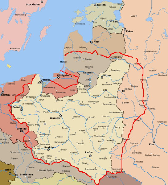
| 描述 |
English: Dmowski's Line (borders of Poland proposed during the Paris Peace Conference) Polski: Linia Dmowskiego |
| 日期 | |
| 来源 |
derivative of File:Rzeczpospolita 1920.png; uploaded to pl wikipedia by Mix321 on 2 Dec 2006 data based on Małkowski, T. Rześniowiecki, J. Historia III, podręcznik dla klasy III gimnazjum, wyd. Gdańskie Wydawnictwo Oświatowe, Gdańsk, 2002 |
| 作者 | derivative: Mix321, original: listed below |
| 授权 (二次使用本文件) |
GFDL |
This image is a derivative work of the following images:
- File:Rzeczpospolita_1920.png licensed with Cc-by-sa-3.0-migrated, GFDL
- 2009-12-05T08:35:28Z DJ Sturm 2000x1534 (369919 Bytes) Correct borders, improved Estonia
- 2009-08-16T14:37:51Z Halibutt 2000x1534 (349775 Bytes) Reverted to version as of 06:33, 8 May 2005 (don't do this. Modify the svg version instead, without those horrible colours and copy-paste leftovers)
- 2009-03-27T14:30:53Z DJ Sturm 2000x1534 (368552 Bytes) Fixed borders of Estonia, Latvia, Lithuania, Soviet Union and Germany, added some towns.
- 2005-05-08T06:33:43Z Halibutt 2000x1534 (349775 Bytes) Reverted to earlier revision
- 2005-05-07T21:41:55Z DeirYassin 2000x1534 (314976 Bytes) Corrected borders of Latvia and Russia, Estonia and Russia according to real interwar, rather than current, borders; the Lithuanian claim is shown.
- 2005-05-07T20:50:35Z DeirYassin 2000x1534 (314976 Bytes)
- 2005-05-07T20:47:17Z DeirYassin 2000x1534 (314976 Bytes)
- 2005-04-07T21:04:53Z Halibutt 2000x1534 (349775 Bytes) New additions: borders of Czechoslovakia corrected, new towns added, more changes to follow. Any suggestions?
- 2005-04-05T07:53:46Z Halibutt 2000x1534 (267139 Bytes) Newer version
- 2005-04-04T07:02:24Z Halibutt 2000x1534 (236688 Bytes) new version: Hungaro-Czechoslovak border corrected and town names added
- 2005-04-02T12:06:46Z Halibutt 2000x1534 (148548 Bytes) new version, colours added
- 2005-04-02T05:30:08Z Halibutt 2000x1534 (151894 Bytes) Early version of my map of Poland and Eastern Europe between 1918 and 1945. So far it features the borders and major towns and cities, as well as the frontlines of the [[Polish-Bolshevik War]]. The colours and fonts and other

|
已授权您依据自由软件基金会发行的无固定段落及封面封底文字(Invariant Sections, Front-Cover Texts, and Back-Cover Texts)的GNU自由文件许可协议1.2版或任意后续版本的条款,复制、传播和/或修改本文件。该协议的副本请见“GNU Free Documentation License”。 |
| 本文件采用知识共享署名-相同方式共享 3.0 未本地化版本许可协议授权。 | ||
| ||
| 本许可协议标签作为GFDL许可协议更新的组成部分被添加至本文件。 |
文件历史
点击某个日期/时间查看对应时刻的文件。
| 日期/时间 | 缩略图 | 大小 | 用户 | 备注 | |
|---|---|---|---|---|---|
| 当前 | 2010年10月20日 (三) 08:46 | | 545 × 600(228 KB) | Mixx321 | dr |
| 2009年12月15日 (二) 15:05 |  | 514 × 496(171 KB) | Piotrus | {{Information |Description=:en: Dmowski's Line (borders of Poland proposed during the Paris Peace Conference)<br>:pl: Linia Dmowskiego |Source=uploaded to pl wikipedia by Mix321 on 2 Dec 2006 |Date=2 Dec 2006 |Author=Mix321 |Permi |
文件用途
没有页面链接到本图像。
全域文件用途
以下其他wiki使用此文件:
- lv.wikipedia.org上的用途