
File:LondonBrent.png
此为最大尺寸。
LondonBrent.png (200 × 155像素,文件大小:23 KB,MIME类型:image/png)
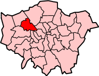
London Borough of Brent
Map drawn by en:User:Morwen

|
已授权您依据自由软件基金会发行的无固定段落及封面封底文字(Invariant Sections, Front-Cover Texts, and Back-Cover Texts)的GNU自由文件许可协议1.2版或任意后续版本的条款,复制、传播和/或修改本文件。该协议的副本请见“GNU Free Documentation License”。 |
| 本文件采用知识共享署名-相同方式共享 3.0 未本地化版本许可协议授权。 | ||
| ||
| 本许可协议标签作为GFDL许可协议更新的组成部分被添加至本文件。 |
文件历史
点击某个日期/时间查看对应时刻的文件。
| 日期/时间 | 缩略图 | 大小 | 用户 | 备注 | |
|---|---|---|---|---|---|
| 当前 | 2005年4月9日 (六) 09:56 | | 200 × 155(23 KB) | Voyager | London Borough of Brent Map drawn by en:User:Morwen {{GFDL}} Category:Maps of London |
文件用途
没有页面链接到本图像。
全域文件用途
以下其他wiki使用此文件:
- ar.wikipedia.org上的用途
- da.wikipedia.org上的用途
- en.wikipedia.org上的用途
- Alperton
- Brondesbury
- Cricklewood
- Harlesden
- Kensal Green
- Kenton, London
- Kilburn, London
- Kingsbury, London
- Neasden
- London Borough of Brent
- Wembley
- Willesden
- Dollis Hill
- Dollis Hill tube station
- Burnt Oak
- Wembley Park
- Colindale
- Queen's Park, London
- Paddock (war rooms)
- Parks and open spaces in the London Borough of Brent
- North Wembley
- Park Royal
- Sudbury, London
- Stonebridge, London
- Mapesbury
- Queensbury, London
- Brondesbury Park
- Preston, London
- Brent Park, Neasden
- Roe Green Park
- Template:LB Brent
- Tokyngton
- Fryent Country Park
- Category:London Borough of Brent
- List of public art in the London Borough of Brent
- St Raphael's Estate
- Church End, Brent
- Chalkhill Estate
- List of people from the London Borough of Brent
- The Library at Willesden Green
- Grade I and II* listed buildings in the London Borough of Brent
- Brent Civic Centre
- Wikipedia:WikiProject Navigation templates/Country subdivisions/United Kingdom/England
- London Designer Outlet
- User:Victor P./sandbox3
- fr.wikipedia.org上的用途
查看本文件的更多全域用途。