
File:Map-of-southeast-asia 1400 CE.png
本预览的尺寸:426 × 600像素。 其他分辨率:170 × 240像素 | 341 × 480像素 | 791 × 1,114像素。
原始文件 (791 × 1,114像素,文件大小:190 KB,MIME类型:image/png)

|
此historical map图片可使用矢量图形重新创建为SVG文件。这具有很多好处;更多信息请参见共享资源:待清理媒体。如果存在此图片的SVG格式,请将其上传,然后将此模板替换为
{{vector version available|新图片名称}}。
建议您将SVG命名为“Map-of-southeast-asia 1400 CE.svg”,这样在使用Vector version available(或Vva)模板时就不需要填写新图片名称参数。 |
摘要
| 描述 |
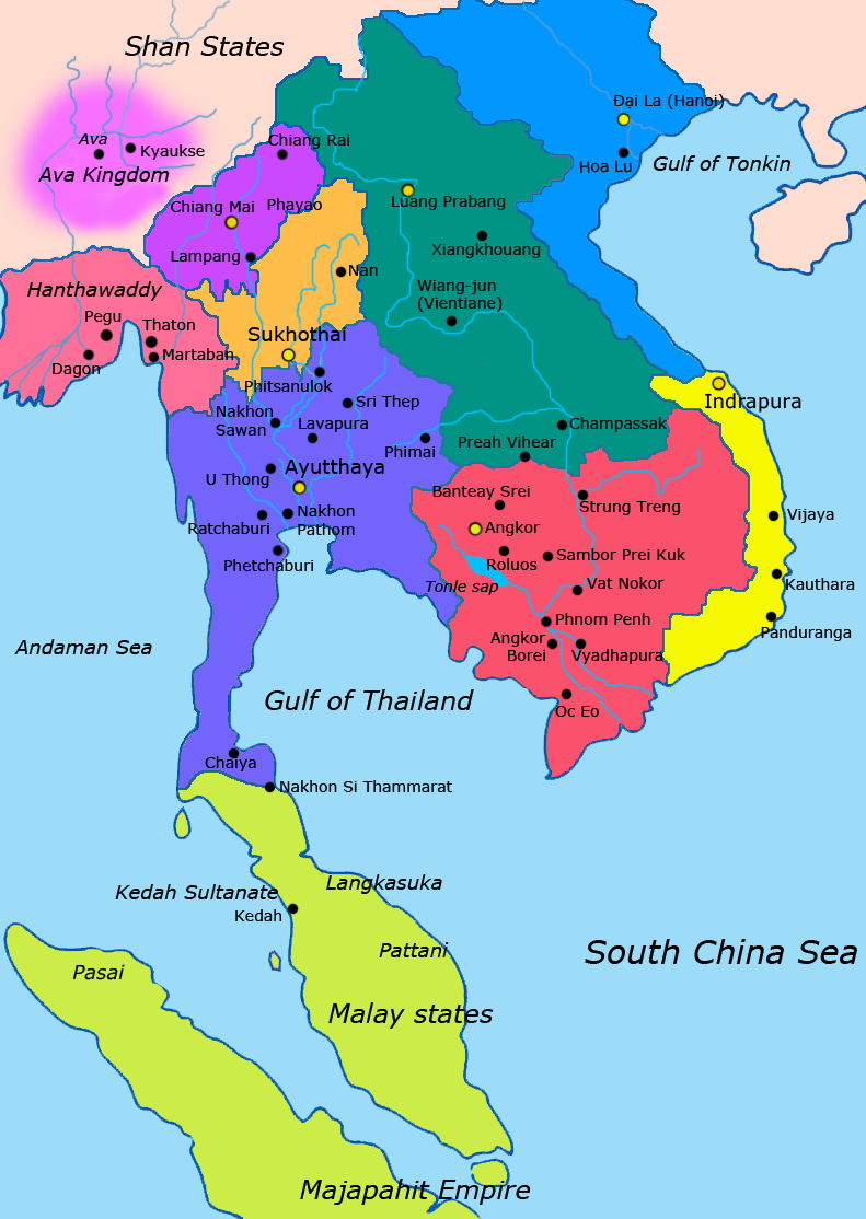
English: Map of Southeast Asia circa 1400 CE, showing Khmer Empire in red, Ayutthaya Kingdom in violet, Lan Xang kingdom in teal, Sukhothai kingdom in orange, Champa in yellow, Kingdom of Lanna in purple, Dai Viet in blue and surrounding states. |
| 日期 | |
| 来源 |
http://ecaimaps.berkeley.edu/animations/2003_03_khmer_animation.swf http://www.britannica.com/EBchecked/media/3395/Khmer-empire-1200 Atlas of world history, Patrick Karl O'brien. Societies, Networks, and Transitions: A Global History, Volume B. Craig A.Lockard http://upload.wikimedia.org/wikipedia/commons/thumb/4/45/Srivijaya_Empire.svg/2000px-Srivijaya_Empire.svg.png File:DvaravatiMapThailand.png http://upload.wikimedia.org/wikipedia/commons/e/eb/Thailand_2002_CIA_map.jpg |
| 作者 | Javierfv1212 |
许可协议
我,本作品著作权人,特此采用以下许可协议发表本作品:
| 本作品采用知识共享CC0 1.0 通用公有领域贡献许可协议授权。 | |
| 采用本宣告发表本作品的人,已在法律允许的范围内,通过在全世界放弃其对本作品拥有的著作权法规定的所有权利(包括所有相关权利),将本作品贡献至公有领域。您可以复制、修改、传播和表演本作品,将其用于商业目的,无需要求授权。
|
文件历史
点击某个日期/时间查看对应时刻的文件。
| 日期/时间 | 缩略图 | 大小 | 用户 | 备注 | |
|---|---|---|---|---|---|
| 当前 | 2022年1月25日 (二) 22:54 | | 791 × 1,114(190 KB) | Yourlocallordandsavior | Reverted to version as of 17:40, 7 March 2021 (UTC) Inaccurate. |
| 2021年4月22日 (四) 08:44 |  | 1,080 × 1,521(643 KB) | Monaonh | Map-of-southeast-asia_1400_CE.png | |
| 2021年3月7日 (日) 17:40 |  | 791 × 1,114(190 KB) | Monaonh | Reverted to version as of 17:26, 7 March 2021 (UTC) | |
| 2021年3月7日 (日) 17:34 |  | 1,080 × 1,521(643 KB) | Monaonh | File:Map-of-southeast-asia_1400_CE.png | |
| 2021年3月7日 (日) 17:26 |  | 791 × 1,114(190 KB) | Monaonh | Reverted to version as of 22:51, 19 July 2011 (UTC) | |
| 2021年3月6日 (六) 16:29 |  | 1,080 × 1,521(643 KB) | Monaonh | File:Map-of-southeast-asia_1400_CE.png | |
| 2011年7月19日 (二) 22:51 |  | 791 × 1,114(190 KB) | Ras67 | cropped | |
| 2011年3月28日 (一) 02:31 |  | 800 × 1,125(256 KB) | Javierfv1212 | {{Information |Description ={{en|1=Map of Southeast Asia circa 1300 CE, showing Khmer Empire in red, Ayutthaya Kingdom in violet, Lan Xang kingdom in teal, Sukhothai kingdom in orange, Champa in yellow, Kingdom of Lanna in purple, Dai Viet in blue and |
文件用途
全域文件用途
以下其他wiki使用此文件:
- ar.wikipedia.org上的用途
- ast.wikipedia.org上的用途
- azb.wikipedia.org上的用途
- az.wikipedia.org上的用途
- ba.wikipedia.org上的用途
- br.wikipedia.org上的用途
- ca.wikipedia.org上的用途
- cs.wikipedia.org上的用途
- de.wikipedia.org上的用途
- en.wikipedia.org上的用途
- eo.wikipedia.org上的用途
- es.wikipedia.org上的用途
- eu.wikipedia.org上的用途
- fa.wikipedia.org上的用途
- fi.wikipedia.org上的用途
- fr.wikipedia.org上的用途
- hi.wikipedia.org上的用途
- hr.wikipedia.org上的用途
- id.wikipedia.org上的用途
- it.wikipedia.org上的用途
- ja.wikipedia.org上的用途
查看本文件的更多全域用途。