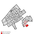
File:Map - NL - 's-Gravenhage - Wijk 42 Ypenburg - Buurt 15 De Bras.svg

页面内容不支持其他语言。
這個文件來自維基共享資源
维基百科,自由的百科全书

原始文件(SVG文件,尺寸为375 × 375像素,文件大小:71 KB)


描述
  • Map - NL - 's-Gravenhage - Wijk 42 Ypenburg - Buurt 15 De Bras.svg
  • locator map showing municipality boundary (2009) and statistical district/neighbourhood boundaries according to CBS
  • Numbering and names of neighboorhoods as defined by CBS in the 2008 Esri publication brt_2008_gen.shp
  • This SVG was generated with a script
日期
来源 own work using free available sources
作者

Michiel1972,

© 本文件的著作权人,Centraal Bureau voor de Statistiek,允许任何人在适当地表明著作权人的姓名的前提下,以任何目的使用本文件。传播,演绎作品,商业用途及所有其他用途被允许。
署名:
Bron: © 2008, Centraal Bureau voor de Statistiek / Topografische Dienst Kadaster

VRT Wikimedia

本作品是自由作品,任何人都可以以任何目的使用。如果您想要使用该内容,只要您遵守本页面上提到的许可协议要求,您不需要请求授权。

维基媒体基金会已收到电子邮件,确认版权持有者同意根据本页面提到的条款发表本作品。该信件已被志愿者回应团队(VRT)成员审阅并存储于我们的授权档案中。受信任的志愿者可前往 工单编号#2007041210008226查阅相关信件。

如果您对存档信件有疑问,请使用VRT通告板 工单链接: https://ticket.wikimedia.org/otrs/index.pl?Action=AgentTicketZoom&TicketNumber=2007041210008226
Find other files from the same ticket: SDC query (SPARQL)

授权
(二次使用本文件)
Attribution ShareAlike 3.0
w:zh:知识共享
署名 相同方式共享
您可以自由地:
  • 共享 – 复制、发行并传播本作品
  • 修改 – 改编作品
惟须遵守下列条件:
  • 署名 – 您必须对作品进行署名,提供授权条款的链接,并说明是否对原始内容进行了更改。您可以用任何合理的方式来署名,但不得以任何方式表明许可人认可您或您的使用。
  • 相同方式共享 – 如果您再混合、转换或者基于本作品进行创作,您必须以与原先许可协议相同或相兼容的许可协议分发您贡献的作品。

说明

添加一行文字以描述该文件所表现的内容

此文件中描述的项目

描繪內容

image/svg+xml

文件历史

点击某个日期/时间查看对应时刻的文件。

日期/时间缩⁠略⁠图大小用户备注
当前2009年4月19日 (日) 19:182009年4月19日 (日) 19:18版本的缩略图375 × 375(71 KB)Michiel1972{{Information |Description=<!--correct utf8, ALSO show buurt boundaries outside the "wijk" of the shown "buurt" --> |Source=own work, using free available sources |Date= |Author=Michiel1972, {{Attribution|nolink=[http://www.cbs.nl Centraal Bureau voor de
2009年3月20日 (五) 22:532009年3月20日 (五) 22:53版本的缩略图375 × 375(35 KB)Michiel1972{{Information |Description=*{{subst:PAGENAME}} *locator map showing municipality boundary (2009) and statistical district/neighbourhood boundaries according to CBS *Numbering and names of neighboorhoods as defined by CBS in the 2008 Esri publication brt_2

以下页面使用本文件:

全域文件用途

以下其他wiki使用此文件: