
File:Oxbow Bend outlook in the Grand Teton National Park.jpg
本预览的尺寸:800 × 568像素。 其他分辨率:320 × 227像素 | 640 × 455像素 | 1,024 × 728像素 | 1,280 × 910像素 | 1,890 × 1,343像素。
原始文件 (1,890 × 1,343像素,文件大小:1.74 MB,MIME类型:image/jpeg)
摘要
| 描述 |
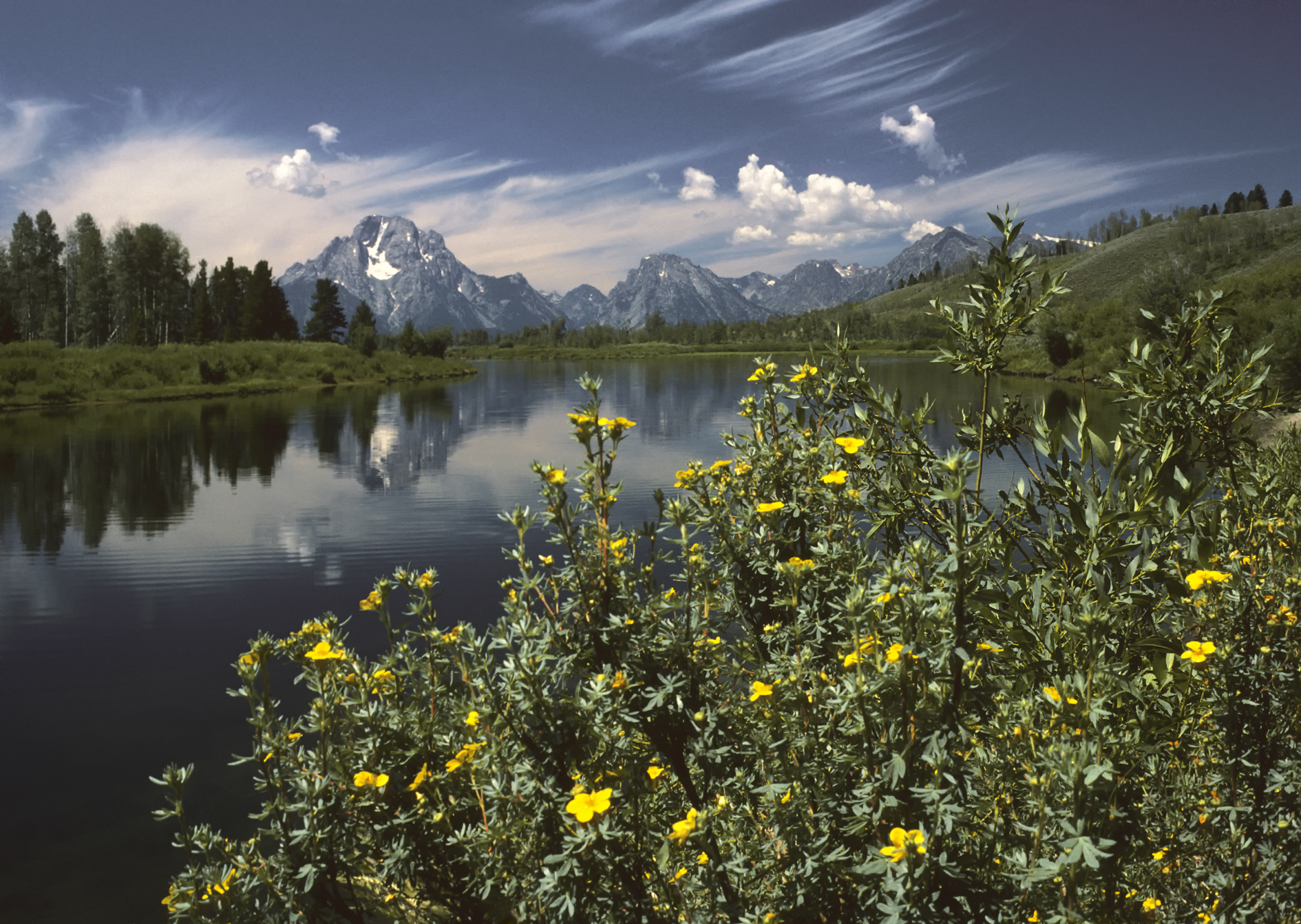
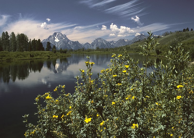
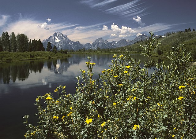
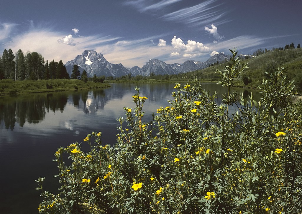
English: Oxbow Bend outlook in the Grand Teton National Park. View over the Snake River to the Mount Moran with the Skillet Glacier (12,605 ft/3,842 m), Bivouac Peak (10,825 ft/3,299 m) and Eagles Rest Peak (11,258 ft/3,431 m) in the Teton Range, Wyoming, United States.
Deutsch: Der Aussichtspunkt Oxbow Bend im Grand Teton National Park, Wyoming, USA mit dem Blick über den Snake River zu den Gipfeln des Mount Moran (3.842 m mit dem Skillet Glacier), des Bivouac Peak (3.299 m) und des Eagles Rest Peak (3.431 m) in dem Teton Range Gebirge.
Français : Vue Oxbow Bend dans le Parc national de Grand Teton, Wyoming, États-Unis. Vue sur la rivière Snake, le Mont Moran avec le Skillet Glacier, (3 842 m), Bivouac Peak (3 299 m) et Eagles Rest Peak (3 431 m) dans le Teton Range.
Italiano: Un meandro del fiume Snake all'interno del Parco nazionale di Grand Teton, nello stato del Wyoming. Domina lo sfondo il Teton Range - con il Monte Moran (3 842 m) sulla sinistra - una catena delle Montagne Rocciose di formazione piuttosto recente (6-9 Ma) per una regione che conserva alcuni tra i depositi geologici più antichi del pianeta, come alcuni scisti e gneiss risalenti al Precambriano. Nella foto si distinguono anche il ghiacciaio Skillet (3 842 m) sul Monte Moran, e le cime del Bivouac Peak (3 299,5 m) and Eagles Rest Peak (3 431 m). |
| 日期 | |
| 来源 | 自己的作品 |
| 作者 | Michael Gäbler |
| 其他版本 |
|

| 相机位置 | | 在以下服务上查看本图像和附近其他图像: OpenStreetMap |
|---|
| 照相机型号 | Olympus OM-1 |
|---|---|
| 底片 | Kodachrome 25 |
| 掃描器 | Nikon Coolscan V ED |
|

本图像被选为2010年7月20日的今日图片。其说明如下: English: Oxbow Bend outlook in the Grand Teton National Park. View over the Snake River to the Mount Moran with the Skillet Glacier (12605 ft), Bivouac Peak (10825 ft) and Eagles Rest Peak (11258 ft) in the Teton Range, Wyoming, United States. 其他语言:
Čeština: Výhled Oxbow Bend v americkém národním parku Grand Teton; pohled přes řeku Snake směrem k Mount Moran s ledovcem Skillet (3 842 m), Bivouac Peak (3 300 m) a Eagles Rest Peak (3 431 m) Dansk: Udsigtspunktet Oxbow Bend i Grand Teton National Park, USA. Forrest ses Snake River og bagved Mount Moran (3.842 m), Bivouac Peak (3.299 m) og Eagles Rest Peak (3.431 m) i Teton-bjergene.. Deutsch: Der Aussichtspunkt Oxbow Bend im Grand Teton National Park, Wyoming, USA mit dem Blick über den Snake River zu den Gipfeln des Mount Moran (3842 m mit dem Skillet Glacier), des Bivouac Peak (3299 m) und des Eagles Rest Peak (3431 m) in dem Teton Range Gebirge. English: Oxbow Bend outlook in the Grand Teton National Park. View over the Snake River to the Mount Moran with the Skillet Glacier (12605 ft), Bivouac Peak (10825 ft) and Eagles Rest Peak (11258 ft) in the Teton Range, Wyoming, United States. Español: Un meandro del río Snake en el interior del Parque Nacional de Grand Teton, en el estado de Wyoming. Domina el fondo el Teton Range —con el Monte Moran (3842 m) a la izquierda—, una cadena de las Montañas Rocosas. Français : Vue Oxbow Bend dans le Parc national de Grand Teton, Wyoming, États-Unis. Vue sur la rivière Snake, le Mont Moran avec le Skillet Glacier, (3 842 m), Bivouac Peak (3 299 m) et Eagles Rest Peak (3 431 m) dans le Teton Range. Italiano: Un meandro del fiume Snake all'interno del Parco nazionale di Grand Teton, nello stato del Wyoming. Domina lo sfondo il Teton Range - con il Monte Moran (3 842 m) sulla sinistra - una catena delle Montagne Rocciose di formazione piuttosto recente (6-9 Ma) per una regione che conserva alcuni tra i depositi geologici più antichi del pianeta, come alcuni scisti e gneiss risalenti al Precambriano. Nederlands: Gezicht over de Snake River (Snakerivier) en de erachter gelegen berg Mount Moran met de gletsjer Skiller en de bergtoppen Bivouac Peak en Eagles Rest Peak vanaf het uitzichtspunt Oxbow Bend in het Grand Teton National Park in de Amerikaanse staat Wyoming. De bergen vormen onderdeel van het Tetongebergte, een bergketen van de Rocky Mountains. Українська: Краєвид Оксбоу Бенд (Вигин Старорічища) в національному парку Гранд Тітон. За річкою Снейк видно гору Моран з льодовиком Скіллет Глетчер, піки Бівуак і Іглз Рест гірського хребта Тітон, Вайомінг, США. 한국어: 그랜드 티턴 국립공원의 우각호(옥스보우 밴드) 전망. 미국 와이오밍 주에 있고, 스네이크 강을 지나 티턴 산맥의 스킬렛 빙하(12,605ft)와 비부악 피크(10,825ft), 이글스 레스트 피크(11,258ft)가 있는 모란 산까지의 전경이다. 日本語: アメリカ合衆国ワイオミング州のグランド・ティトン国立公園 中文: 美国怀俄明州大蒂顿国家公园风景。 中文(繁體): 美國懷俄明州大蒂頓國家公園風景 |
许可协议
I, Michael Gäbler,本作品著作权人,特此采用以下许可协议发表本作品:
本文件采用知识共享署名 3.0 未本地化版本许可协议授权。
署名: I, Michael Gäbler
- 您可以自由地:
- 共享 – 复制、发行并传播本作品
- 修改 – 改编作品
- 惟须遵守下列条件:
- 署名 – 您必须对作品进行署名,提供授权条款的链接,并说明是否对原始内容进行了更改。您可以用任何合理的方式来署名,但不得以任何方式表明许可人认可您或您的使用。
文件历史
点击某个日期/时间查看对应时刻的文件。
| 日期/时间 | 缩略图 | 大小 | 用户 | 备注 | |
|---|---|---|---|---|---|
| 当前 | 2009年12月20日 (日) 16:05 | | 1,890 × 1,343(1.74 MB) | Michael Gäbler | {{Information |Description={{en|1=Oxbow Bend outlook in the Grand Teton National Park. View over the Snake River to the Mount Moran with the Skillet Glacier (12605 ft), Bivouac Peak (10825 ft) and Eagles Rest Peak (11258 ft) in the Grand Teton, Wyoming, U |
文件用途
以下3个页面使用本文件:
全域文件用途
以下其他wiki使用此文件:
- ar.wikipedia.org上的用途
- azb.wikipedia.org上的用途
- ba.wikipedia.org上的用途
- bn.wikipedia.org上的用途
- ceb.wikipedia.org上的用途
- crh.wikipedia.org上的用途
- cv.wikipedia.org上的用途
- da.wikipedia.org上的用途
- de.wikivoyage.org上的用途
- en.wikipedia.org上的用途
- fa.wikipedia.org上的用途
- پارک ملی گرند تیتون
- ویکیپدیا:نگارههای برگزیده/جاها/طبیعت
- ویکیپدیا:گزیدن نگاره برگزیده/نوامبر-۲۰۱۲
- ویکیپدیا:نگاره روز/مارس ۲۰۱۳
- ویکیپدیا:گزیدن نگاره برگزیده/Oxbow Bend outlook in the Grand Teton National Park.jpg
- الگو:نر/2013-03-14
- الگو:نر محافظت شده/2013-03-14
- درگاه:ایالات متحده آمریکا/نگاره برگزیده
- درگاه:ایالات متحده آمریکا/نگاره برگزیده/۳۵
- بحث کاربر:Magic Wizard/بایگانی ۱
- fr.wikipedia.org上的用途
- he.wikipedia.org上的用途
- hu.wikipedia.org上的用途
- it.wikipedia.org上的用途
- ko.wikipedia.org上的用途
- krc.wikipedia.org上的用途
- lbe.wikipedia.org上的用途
- mg.wikipedia.org上的用途
- mk.wikipedia.org上的用途
- nl.wikipedia.org上的用途
- os.wikipedia.org上的用途
- pl.wikipedia.org上的用途
- pt.wikipedia.org上的用途
- ru.wikipedia.org上的用途
- ru.wikinews.org上的用途
- sah.wikipedia.org上的用途
- sv.wikipedia.org上的用途
查看本文件的更多全域用途。