
File:SevenYearsWar.png

本预览的尺寸:800 × 370像素。 其他分辨率:320 × 148像素 | 640 × 296像素 | 1,357 × 628像素。
原始文件 (1,357 × 628像素,文件大小:41 KB,MIME类型:image/png)

|
此military map图片可使用矢量图形重新创建为SVG文件。这具有很多好处;更多信息请参见共享资源:待清理媒体。如果存在此图片的SVG格式,请将其上传,然后将此模板替换为
{{vector version available|新图片名称}}。
建议您将SVG命名为“SevenYearsWar.svg”,这样在使用Vector version available(或Vva)模板时就不需要填写新图片名称参数。 |
摘要
| 描述 |
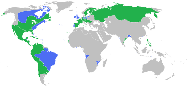
English: Locator map of the competing sides of the Seven Years War before outset of the war (mid-1750s). Blue: Great Britain, Portugal with more. Green: France, Spain with more. Great Britain, Prussia, Portugal, with allies
France, Spain, Austria, Russia, Sweden with allies Français : Carte montrant les forces en présence lors de la guerre de Sept Ans (milieu des années 1750).
Grande Bretagne, Prusse, Portugal, leurs alliés et dépendances
France, Espagne, Autriche, Russie, Suède, leurs alliés et dépendances (Partially based on Atlas of World History (2007) - There was also a treaty in 1783, Imperialism and Revolutions, map) |
| 日期 | |
| 来源 | 自己的作品 |
| 作者 | Gabagool |
许可协议
我,本作品著作权人,特此采用以下许可协议发表本作品:
本文件采用知识共享署名 3.0 未本地化版本许可协议授权。
- 您可以自由地:
- 共享 – 复制、发行并传播本作品
- 修改 – 改编作品
- 惟须遵守下列条件:
- 署名 – 您必须对作品进行署名,提供授权条款的链接,并说明是否对原始内容进行了更改。您可以用任何合理的方式来署名,但不得以任何方式表明许可人认可您或您的使用。
文件历史
点击某个日期/时间查看对应时刻的文件。
| 日期/时间 | 缩略图 | 大小 | 用户 | 备注 | |
|---|---|---|---|---|---|
| 当前 | 2009年6月23日 (二) 15:54 | | 1,357 × 628(41 KB) | Gabagool | corrected India more appropriatly |
| 2009年6月11日 (四) 13:59 |  | 1,357 × 628(41 KB) | Gabagool | some fixes | |
| 2009年6月11日 (四) 11:16 |  | 1,357 × 628(41 KB) | Gabagool | more details in Germany | |
| 2009年6月6日 (六) 22:20 |  | 1,357 × 628(41 KB) | Gabagool | {{Information |Description={{en|1=Locator map of the competing sides of the Seven Years War before outset of the war (early 1750s).<br> Blue: Great Britain, Portugal with more. Green: France, Spain with more. Light green: French largest expansion in India |
文件用途
以下3个页面使用本文件:
全域文件用途
以下其他wiki使用此文件:
- af.wikipedia.org上的用途
- als.wikipedia.org上的用途
- an.wikipedia.org上的用途
- ar.wikipedia.org上的用途
- arz.wikipedia.org上的用途
- ast.wikipedia.org上的用途
- az.wikipedia.org上的用途
- ba.wikipedia.org上的用途
- bg.wikipedia.org上的用途
- bn.wikipedia.org上的用途
- br.wikipedia.org上的用途
- bs.wikipedia.org上的用途
- ca.wikipedia.org上的用途
- cs.wikipedia.org上的用途
- da.wikipedia.org上的用途
- de.wikipedia.org上的用途
- dsb.wikipedia.org上的用途
- en.wikipedia.org上的用途
- eo.wikipedia.org上的用途
- es.wikipedia.org上的用途
- fa.wikipedia.org上的用途
- fi.wikipedia.org上的用途
- fr.wikipedia.org上的用途
- ga.wikipedia.org上的用途
- he.wikipedia.org上的用途
- hi.wikipedia.org上的用途
- hsb.wikipedia.org上的用途
- is.wikipedia.org上的用途
- it.wikipedia.org上的用途
- ja.wikipedia.org上的用途
- ko.wikipedia.org上的用途
- lt.wikipedia.org上的用途
- lv.wikipedia.org上的用途
查看本文件的更多全域用途。