
File:Spice Islands (Tanzania).svg

此SVG文件的PNG预览的大小:486 × 599像素。 其他分辨率:195 × 240像素 | 389 × 480像素 | 623 × 768像素 | 831 × 1,024像素 | 1,661 × 2,048像素 | 713 × 879像素。
原始文件 (SVG文件,尺寸为713 × 879像素,文件大小:15 KB)
.svg?uselang=zh)
.svg?uselang=zh)
.svg?action=history&uselang=zh)
.svg)
摘要
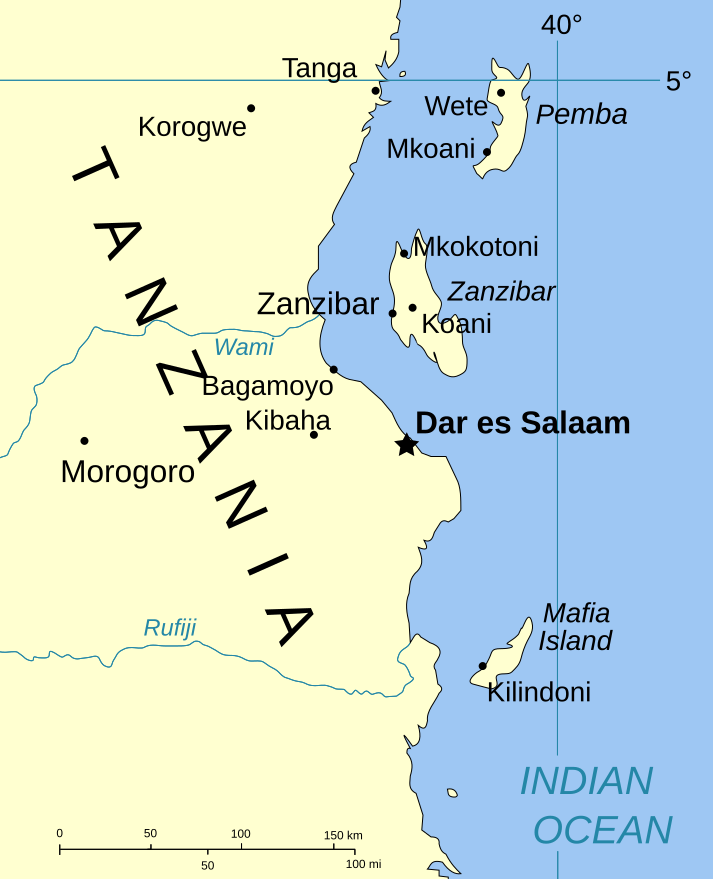
| 描述 | Part of the map of Tanzania, showing the Spice Islands. |
| 日期 | |
| 来源 | Vectors self-made in Inkscape. Source was cropped from http://www.lib.utexas.edu/maps/africa/tanzania_pol_2003.jpg which is said to be in the public domain in the Perry-Castañeda Map Collection FAQ. |
| 作者 | Mysid |
| 授权 (二次使用本文件) |
PD |
| 其他版本 |
Image:Spice Islands (Zanzibar highlighted).svg in French : Image:Spice_Islands_Tanzania-fr.svg in French : Image:Spice_Islands-Zanzibar_highlighted-fr.svg |
.svg)
许可协议
| 我,本作品著作权人,释出本作品至公有领域。这适用于全世界。 在一些国家这可能不合法;如果是这样的话,那么: 我无条件地授予任何人以任何目的使用本作品的权利,除非这些条件是法律规定所必需的。 |
文件历史
点击某个日期/时间查看对应时刻的文件。
| 日期/时间 | 缩略图 | 大小 | 用户 | 备注 | |
|---|---|---|---|---|---|
| 当前 | 2007年1月6日 (六) 20:01 | | 713 × 879(15 KB) | Mysid | (a bit more) standard colors |
| 2006年5月29日 (一) 06:44 |  | 713 × 879(20 KB) | Mysid | corrected buggy scale | |
| 2006年5月29日 (一) 06:40 |  | 713 × 879(20 KB) | Mysid | New version, exported from CorelDraw (inkscape seems buggy) | |
| 2006年5月28日 (日) 18:23 |  | 713 × 893(37 KB) | Mysid | {{Information |Description=Part of the map of Tanzania, showing the Spice Islands. |Source=Vectors self-made in Inkscape. Source was cropped from http://www.lib.utexas.edu/maps/africa/tanzania_pol_2003.jpg which is said to be in the pu |
文件用途
以下页面使用本文件:
全域文件用途
以下其他wiki使用此文件:
- ckb.wikipedia.org上的用途
- da.wikipedia.org上的用途
- eo.wikipedia.org上的用途
- eu.wikipedia.org上的用途
- fa.wikipedia.org上的用途
- fo.wikipedia.org上的用途
- fr.wikipedia.org上的用途
- hr.wikipedia.org上的用途
- it.wikipedia.org上的用途
- ja.wikipedia.org上的用途
- mi.wikipedia.org上的用途
- nl.wikipedia.org上的用途
- no.wikipedia.org上的用途
- pt.wikipedia.org上的用途
- sr.wikipedia.org上的用途
- sv.wikipedia.org上的用途
- vi.wikipedia.org上的用途
.svg)