
File:US insular areas-B.png

原始文件 (1,482 × 624像素,文件大小:51 KB,MIME类型:image/png)

|
File:US insular areas SVG.svg是此文件的矢量版本。 如果此文件质量不低于原点阵图,就应该将这个PNG格式文件替换为此文件。
File:US insular areas-B.png → File:US insular areas SVG.svg
更多信息请参阅Help:SVG/zh。 |
 |
摘要
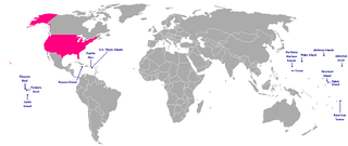
This is a map of the US Insular areas. The first version of this map was based off Image:BlankMap-World-v6.png by User:Astrokey44 with the locations of a few islands added; the source for this are two CIA maps; the maps are a map of the Pacific region and a map of the United States Pacific Island Wildlife Refuges. Hawaii has also been added to the map. Names of the islands are from the CIA Factbook. The second version is based off Image:Dependent_territories_2007.png by User:Sesmith.
For a version color-coded by each islands' status, see Image:US_insular_areas.png. For a version with the freely associated states, see Image:US_insular_areas-B FAS.png.
The previous map is under the GFDL; therefore, this map is too.
许可协议

|
已授权您依据自由软件基金会发行的无固定段落及封面封底文字(Invariant Sections, Front-Cover Texts, and Back-Cover Texts)的GNU自由文件许可协议1.2版或任意后续版本的条款,复制、传播和/或修改本文件。该协议的副本请见“GNU Free Documentation License”。 |
| 本文件采用知识共享署名-相同方式共享 3.0 未本地化版本许可协议授权。 | ||
| ||
| 本许可协议标签作为GFDL许可协议更新的组成部分被添加至本文件。 |
文件历史
点击某个日期/时间查看对应时刻的文件。
| 日期/时间 | 缩略图 | 大小 | 用户 | 备注 | |
|---|---|---|---|---|---|
| 当前 | 2008年1月9日 (三) 11:10 | | 1,482 × 624(51 KB) | Hoshie | rebuilt using User:Sesmith's maps; more to come. |
| 2007年3月17日 (六) 10:43 |  | 1,482 × 624(32 KB) | Hoshie | This is a map of the US Insular areas. The base map is Image:BlankMap-World-v6.png by User:Astrokey44 with the locations of a few islands added; the source for this are two CIA maps; the maps are a [https://www.cia.gov/cia/publications/factbook/r |
文件用途
没有页面链接到本图像。
全域文件用途
以下其他wiki使用此文件:
- en.wikipedia.org上的用途
- kk.wikipedia.org上的用途