
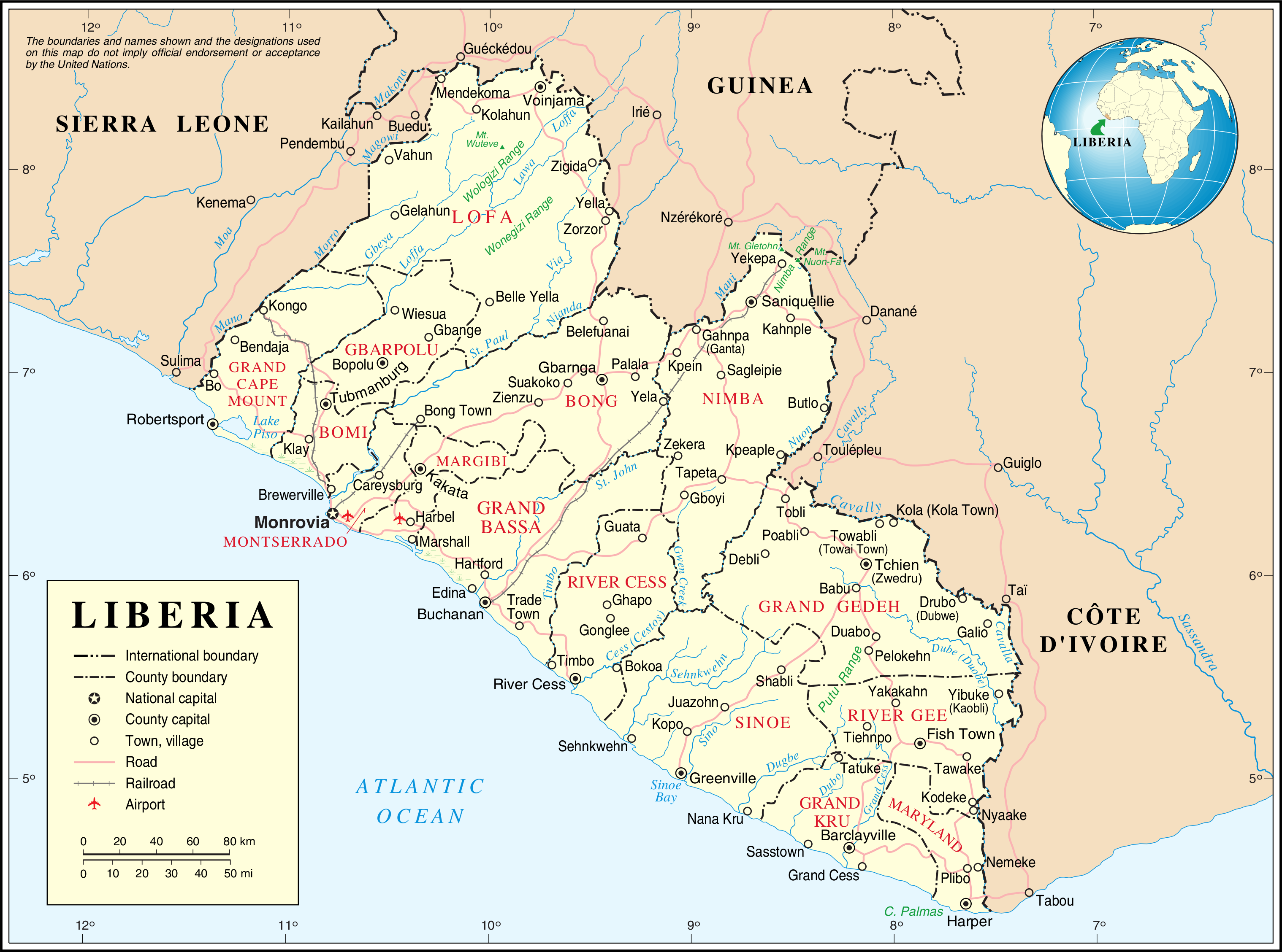
File:Un-liberia.png
原始文件 (3,037 × 2,257像素,文件大小:1.42 MB,MIME类型:image/png)
| This image is a map derived from a United Nations map.
Unless stated otherwise, UN maps are to be considered in the public domain. This applies worldwide. UN maps are, in principle, open source material and you can use them in your work or for making your own map. UN requests however that you delete the UN name, logo and reference number upon any modification to the map. Content of your map will be your responsibility. You can state in your publication, if you wish, something like: based on UN map … (map name, map number, revision number and date). See: Geospatial Information Section. And: Geospatial, location data for a better world. |
 |
文件历史
点击某个日期/时间查看对应时刻的文件。
| 日期/时间 | 缩略图 | 大小 | 用户 | 备注 | |
|---|---|---|---|---|---|
| 当前 | 2007年10月24日 (三) 01:29 | | 3,037 × 2,257(1.42 MB) | Jeroen | {{UN map}} Category:Maps of Liberia |
文件用途
以下页面使用本文件:
全域文件用途
以下其他wiki使用此文件:
- ar.wikipedia.org上的用途
- ast.wikipedia.org上的用途
- az.wikipedia.org上的用途
- bs.wikipedia.org上的用途
- ca.wikipedia.org上的用途
- Primera Guerra Civil liberiana
- Resolució 856 del Consell de Seguretat de les Nacions Unides
- Resolució 1020 del Consell de Seguretat de les Nacions Unides
- Resolució 1041 del Consell de Seguretat de les Nacions Unides
- Resolució 1071 del Consell de Seguretat de les Nacions Unides
- Resolució 1395 del Consell de Seguretat de les Nacions Unides
- Resolució 1458 del Consell de Seguretat de les Nacions Unides
- Resolució 1549 del Consell de Seguretat de les Nacions Unides
- Resolució 1579 del Consell de Seguretat de les Nacions Unides
- Resolució 1607 del Consell de Seguretat de les Nacions Unides
- Resolució 1626 del Consell de Seguretat de les Nacions Unides
- Resolució 1683 del Consell de Seguretat de les Nacions Unides
- Resolució 1712 del Consell de Seguretat de les Nacions Unides
- Resolució 1731 del Consell de Seguretat de les Nacions Unides
- Resolució 1750 del Consell de Seguretat de les Nacions Unides
- Resolució 1819 del Consell de Seguretat de les Nacions Unides
- Resolució 1854 del Consell de Seguretat de les Nacions Unides
- Resolució 1885 del Consell de Seguretat de les Nacions Unides
- Resolució 2128 del Consell de Seguretat de les Nacions Unides
- Missió de les Nacions Unides a Libèria
- ckb.wikipedia.org上的用途
- cs.wikipedia.org上的用途
- de.wikipedia.org上的用途
- de.wikivoyage.org上的用途
- en.wikipedia.org上的用途
- List of cities in Liberia
- Outline of Liberia
- Administrative divisions of Liberia
- United Nations Security Council Resolution 856
- United Nations Security Council Resolution 1020
- United Nations Security Council Resolution 1041
- United Nations Security Council Resolution 1071
- Category:Populated places in Liberia
- United Nations Security Council Resolution 1395
查看本文件的更多全域用途。