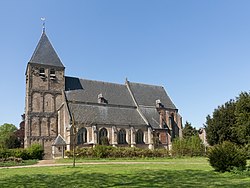
雷登 (荷蘭)
| 雷登 Rheden | |||
|---|---|---|---|
| 市镇 | |||
 | |||
| |||
 在海爾德蘭省的位置 | |||
| 坐标:52°1′N 6°3′E / 52.017°N 6.050°E坐标:52°1′N 6°3′E / 52.017°N 6.050°E | |||
| 國家 | 荷蘭 | ||
| 省份 | 海爾德蘭省 | ||
| 政府[1] | |||
| • 行政机构 | Municipal council | ||
| • 市長 | Petra van Wingerden-Boers (VVD) | ||
| 面积[2] | |||
| • 总计 | 84.35 平方公里(32.57 平方英里) | ||
| • 陸地 | 81.74 平方公里(31.56 平方英里) | ||
| • 水域 | 2.61 平方公里(1.01 平方英里) | ||
| 海拔[3] | 28 公尺(92 英尺) | ||
| 人口(1月 2019)[4] | |||
| • 總計 | 43,640人 | ||
| • 密度 | 534人/平方公里(1,380人/平方英里) | ||
| 居民称谓 | Rhedenaar | ||
| 时区 | CET(UTC+1) | ||
| • 夏时制 | CEST(UTC+2) | ||
| Postcode | 6880–6883, 6950–6957, 6990–6994 | ||
| Area code | 026, 0313 | ||
| 網站 | www | ||
雷登(荷蘭語:Rheden)是荷蘭的一個市镇,位於荷蘭東部。雷登設立於2013年1月1日,是由七個村鎮合併而成設立的市镇[5]。
參考資料[编辑]
- ^ College burgemeester en wethouders [Board of mayor and aldermen]. Gemeente Rheden. [16 July 2014]. (原始内容存档于2014年6月1日) (荷兰语).
- ^ Kerncijfers wijken en buurten [地区关键统计数字]. 荷蘭中央統計局统计数据. 荷蘭中央統計局. 2013-07-02 [2014-03-12] (荷兰语).
- ^ Postcodetool for 6994AB. Actueel Hoogtebestand Nederland. Het Waterschapshuis. [16 July 2014]. (原始内容存档于2018-12-25) (荷兰语).
- ^ Bevolkingsontwikkeling; regio per maand [Population growth; regions per month]. 荷蘭中央統計局统计数据. 荷蘭中央統計局. 1 January 2019 [2019年1月1日] (荷兰语).
- ^ Statistics on Rheden.nl 互联网档案馆的存檔,存档日期2013-12-15.
外部連結[编辑]
 维基共享资源上的相關多媒體資源:雷登
- Official website (页面存档备份,存于互联网档案馆)


