
File:Luzon Strait n7184.jpg

本预览的尺寸:318 × 598像素。 其他分辨率:127 × 240像素 | 542 × 1,020像素。
原始文件 (542 × 1,020像素,文件大小:77 KB,MIME类型:image/jpeg)
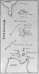
| 描述 | Old map of the Luzon Strait (not labeled), including the Bashi Channel, between Orchid Island (Botel Tobago on the map) of Taiwan and the Batan Islands of the Philippines. Names may be out of date. Japanese caption: "Islands between Taiwan and Luzon". | |||||
| 日期 | 未知日期 | |||||
| 来源 |
From digital archive of the University of Tokyo. [1] Cropped by a-giâu. |
|||||
| 作者 | anthropologist Torii Ryūzō (1870-1953) | |||||
| 授权 (二次使用本文件) |
|


文件历史
点击某个日期/时间查看对应时刻的文件。
| 日期/时间 | 缩略图 | 大小 | 用户 | 备注 | |
|---|---|---|---|---|---|
| 当前 | 2004年11月11日 (四) 23:30 | | 542 × 1,020(77 KB) | A-giâu | Old map of the Luzon Strait,(not labeled), including the Bashi Channel, between Orchid Island (Botel Tobago in the map) of Taiwan and the Batanes of the Philippines. Names may be out of date. From digital archive of the Universit |
文件用途
全域文件用途
以下其他wiki使用此文件:
- ar.wikipedia.org上的用途
- ast.wikipedia.org上的用途
- az.wikipedia.org上的用途
- bcl.wikipedia.org上的用途
- be.wikipedia.org上的用途
- ca.wikipedia.org上的用途
- ceb.wikipedia.org上的用途
- cs.wikipedia.org上的用途
- da.wikipedia.org上的用途
- de.wikipedia.org上的用途
- en.wikipedia.org上的用途
- es.wikipedia.org上的用途
- eu.wikipedia.org上的用途
- fa.wikipedia.org上的用途
- fr.wikipedia.org上的用途
- he.wikipedia.org上的用途
- hi.wikipedia.org上的用途
- id.wikipedia.org上的用途
- ilo.wikipedia.org上的用途
- it.wikipedia.org上的用途
- ja.wikipedia.org上的用途
- ko.wikipedia.org上的用途
- lt.wikipedia.org上的用途
- mk.wikipedia.org上的用途
- nl.wikipedia.org上的用途
查看本文件的更多全域用途。